Gallery:C48 (Inverclyde)
From Roader's Digest: The SABRE Wiki
Jump to navigation
Jump to search
Class III Roads (Inverclyde) > C48 (Inverclyde)
Parent gallery for Class III roads in Inverclyde
This gallery has no child categories
C48 (Inverclyde)
At Majeston Farm, looking towards Cauldron Hill and the Greenock Cut.

The road crosses the Greenock Cut at the top of this short rise.

The north end of the C48 (Inverclyde) at the junction with the A78 dual carriageway at Spango Valley.
_Shielhill_Road_-_Geograph_-_6220748.jpg)
Millhouse Road joins on the right. The white lines are a recent addition.
The former Shielhill Glen railway crossed the road on a level crossing at this point, running approximately from the pole on the left to the metal gate near the centre and following the hedge line to the next pole and beyond.
_Shielhill_Road_-_Geograph_-_6220753.jpg)
Looking towards Maheston, the line of the former Shielhill Glen railway can be seen on the right.
_Roadworks_on_Shielhill_Road_-_Geograph_-_3101925.jpg)
Long term works to restore the road at the top of Shielhill Glen following a landslide in late 2011. The road is completely blocked, even to pedestrians and cyclists who face a lengthy detour.
_Road_Closed_-_Geograph_-_2911417.jpg)
Shielhill Road to Loch Thom and Cornalees is closed due to a landslide near the top of Shielhill Glen (2011/12).
_The_road_to_Cornalees_-_Geograph_-_5240363.jpg)
Known as Dunrod Road and also Shielhill Road. Hillside Hill is in the distance.
_Dunrod_Road_-_Geograph_-_5238312.jpg)
Looking towards Compensation Reservoir from Loch Thom. Also known locally as Shielhill Road and Loch Thom Road. Dunrod Hill is in the distance.
_The_road_to_Loch_Thom_-_Geograph_-_5238283.jpg)
Known locally as Dunrod Road or Shielhill Road.Loch Thom can be seen.
_Shielhill_Road_-_Geograph_-_3254125.jpg)
This, the steepest section of the road, was washed away in a landslide on 29th November 2011 and was closed for around a year while substantial repairs were carried out.
_Shielhill_Road_-_Geograph_-_3254123.jpg)
This, the steepest section of the road, was washed away in a landslide on 29th November 2011 and was closed for around a year while substantial repairs were carried out.
_Greenock_Cut_-_Geograph_-_4426617.jpg)
The cut runs alongside Shielhill Road to the south of Shielhill Farm.
_Road_junction_at_Loch_Thom_-_Geograph_-_2298030.jpg)
C47 (Inverclyde) Old Largs Road is in the foreground, the C48 (Inverclyde) road to Cornalees and Shielhill Glen branches off to the left. Ben Lomond makes an appearance in the distance.
_Cyclist_in_Shielhill_Glen_-_Geograph_-_3967462.jpg)
Viewed from the Greenock Cut.
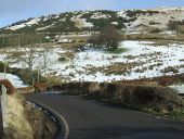
_Wintry_Shielhill_Glen_Road_-_Geograph_-_1735727.jpg)
At the entrance to Majeston farm. Cauldron Hill and Dunrod Hill are in the distance.
_Toppled_crane_in_Shielhill_Glen_-_Geograph_-_1159348.jpg)
The crane toppled off the road to the right and somehow managed to end up on its side, with its wheels facing away from the road. Two larger cranes were brought in to assist in the recovery operation.
_Toppled_crane_in_Shielhill_Glen_-_Geograph_-_1159345.jpg)
The toppled crane in the foreground is about to be righted by the two cranes on the specially constructed embankment in the background. The crane toppled off the road a few weeks earlier, having taken a wrong turn onto the narrow glen road.
_Loch_Thom_-_Geograph_-_1417666.jpg)
The road from Shielhill Glen crosses the southern tip of the loch on a stone arched bridge. The loch is unusually high for the time of year. This is the south end of the road, the junction with the C47 (Inverclyde) is just out of sight on the left).
_-_C47_(Inverclyde)_Road_junction_at_Loch_Thom_-_Geograph_-_5240356.jpg)
C48 is in the foreground. Turn left for Greenock, right for Largs.
_-_C47_(Inverclyde)_Old_Largs_Road_-_Geograph_-_1417701.jpg)
C47 Old Largs Road crosses the photo from left to right. The C48 road in the foreground is from Cornalees Bridge and Shilehill Glen.
_Auchness_Bridge_-_Geograph_-_5760194.jpg)
On Dunrod Road, crossing the Spango Burn, just upstream from the confluence of Kip Water, near the junction with the A78 dual carriageway at Spango Valley. The parapets were rebuilt in 2017.
_Toppled_crane_in_Shielhill_Glen_-_Geograph_-_1159327.jpg)
The crane on the right toppled off the road a few weeks previously (January 2009), having taken a wrong turn onto the narrow, twisting glen road. A new embankment and temporary road were constructed to enable recovery of the crane by two similar cranes.

At the south end of Loch Thom where the C48 meets the C47 (top right).

The sign for the C48 junction (C48 can be seen in the left distance).

At the Junction with the C48 road to Cornalees and Inverkip at the south end of Loch Thom.

C47 Old Largs Road is in the foreground, the C48 road to Cornalees and Shielhill Glen branches off to the left. Ben Lomond makes an appearance in the distance.