Gallery:Chester


Nice sign, shame about the yellow paint.
Originally uploaded to Coppermine on Aug 20, 2009 by kieron
This sign is on a traffic island at the A5268/A51 junction. As such, the number A51 does not benefit from brackets.
Originally uploaded to Coppermine on Aug 21, 2009 by kieron
There are a few blue-bordered signs along Sealand Road. This is the only one which tells you which road you are on, though.
Originally uploaded to Coppermine on May 29, 2009 by kieron
This is one of the newer direction signs at the Grosvenor roundabout in Chester. Some of the other ones identify the road as the A483 and as being a road to Wrexham. Saltney (which is in North Wales) is 2 miles away, Lache a bit closer.
Originally uploaded to Coppermine on Mar 21, 2009 by kieron
An arrangement of signs at an exit on the A483/A5104 junction in Chester. Fortunately, the advanced signs are clearer. The road here actually is Wrexham Road (and part of the primary route to Wrexham at that), but I don't know whether the A549 still formed part of a good route to Mold when 'Conway' stopped being used on road signs.
Originally uploaded to Coppermine on Mar 11, 2009 by kieron
Photo of the Old Dee Bridge just south of Chester city centre. This stone bridge was built in 1353 on the site of previous bridges which have existed since the Romans occupied Britain.
Taken on 3 April 2008.
Originally uploaded to Coppermine on Apr 18, 2008 by Nicholas
A route confirmation sign on the A55 spur at Broughton, with monolingual destinations and a high fractional distance.
Originally uploaded to Coppermine on Jun 09, 2007 by kieron

Two primary A roads leave the roundabout here, not that you can tell from the picture. The sign for the road on the left reads Nantwich (A51), Whitchurch (A41) (sorry about the light), but is actually the A51.
The road in the centre of the picture is the A5268, leading to the Pepper Street car park and the road to Wrexham beyond it.
Originally uploaded to Coppermine on Jun 22, 2008 by kieron
This is an 'All through traffic' sign on the junction between two primary routes. Perhaps not for much longer, though.
Originally uploaded to Coppermine on Jun 22, 2008 by kieron
A sign at the original end of the A56 in Chester. The writing reads 'FRODSHAM ST A56', with '1921' below it.
Originally uploaded to Coppermine on Feb 11, 2007 by kieron
Typical street sign in Chester, to contrast with the one opposite. It happens to be at the pre-ring road end of the A56.
Originally uploaded to Coppermine on Feb 11, 2007 by kieron
The south east bridge abutment for Chester's Grosvenor Bridge, built of limestone but capped and faced with sandstone. The side arch allows an access track and a public footpath to pass through to the Dingle. The A483 Wrexham Road passes over the bridge (and the River Dee) into Chester.


Boughton Heath 'Sainsbury's' Roundabout.
A41 into Chester in Boughton

_Dennis_Turner_-_Geograph_-_869109.jpg)
_Jaggery_-_Geograph_-_3752146.jpg)
The A5268 Pepper Street passes under The Newgate between a gap in the City Wall. In 1938 The Newgate replaced a gateway in the City Wall, to give greater width and headroom on a heavily trafficked street. Less than two decades after being built, The Newgate was Grade II listed in 1955.


The signs pointing down the A55 westbound into Wales.
Originally uploaded to Coppermine on May 03, 2006 by antster1983_-_Geograph_-_795866.jpg)
These signs and road markings make it very clear which lane traffic on the A56 dual carriageway should use on approach to the roundabout.
There's also a blue bordered sign for Mickle Trafford, although it sadly does not suggest which lane to use.
Originally uploaded to Coppermine on May 29, 2009 by kieron

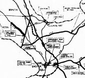

Key: Solid line = roads under construction or complete Dashed line = in planning pool Black dotted line = future government scheme
White dotted line = future County schemes
