Gallery:Fortwilliam Roundabout
From Roader's Digest: The SABRE Wiki
Jump to navigation
Jump to search
Junctions in Northern Ireland > Fortwilliam Roundabout
This gallery has no child categories
Fortwilliam Roundabout
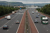
The M2 at Fortwilliam
The building of the foreshore section of the M2 between Whitla Street, Belfast and Greencastle was a major civil engineering project. It involved reclamation of a large part of Belfast Lough and the transport of more than 4 million tons of fill, by rail, from Magheramorne near Larne. Work started in 1966 with the road opening in 1973. This is the view north from the overbridge at Fortwilliam. The landscaping has taken well although it is hard to hide a motorway! Those with an interest in such things will note the additional hard shoulder on the inside. This section of road carries more than 90,000 vehicles each day.
The building of the foreshore section of the M2 between Whitla Street, Belfast and Greencastle was a major civil engineering project. It involved reclamation of a large part of Belfast Lough and the transport of more than 4 million tons of fill, by rail, from Magheramorne near Larne. Work started in 1966 with the road opening in 1973. This is the view north from the overbridge at Fortwilliam. The landscaping has taken well although it is hard to hide a motorway! Those with an interest in such things will note the additional hard shoulder on the inside. This section of road carries more than 90,000 vehicles each day.
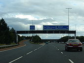
M2 FORTWILLIAM
The construction of an additional (southbound) lane from Sandyknowes to Greencastle and the closure of the northbound inside lane is having an effect on peak traffic flow. This queue is appx 2� miles long. Taken at 16.35 before the real peak flow had started. 28 September 2007. (This is a daily event M-F).
Originally uploaded to Coppermine on Nov 12, 2007 by Wee Hughie

