Gallery:Google Mapping
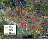
A useful little map, showing speed limits and speed cameras in Southampton on A and B roads at present (07/06/2006). 30mph is red, 40mph is orange, 50mph is yellow, NSL is green, and motorways are blue. The little coloured squares represent fixed speed cameras, and are positioned on the side of the road on which they apply.
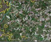
Originally uploaded to Coppermine on Jun 07, 2006 by sotonsteveThis Google Earth image demonstrates how much land the M3 (blue line, thickness to cover the actual roadway) takes up. The areas circled by a yellow line are built up areas, with Alresford, Winchester, Fair Oak/Bishopstoke, Colden Common (village) and Bishops Waltham shown. The rest of the land is open countryside. The image is about 16 miles across.
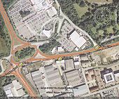
Originally uploaded to Coppermine on Jul 04, 2006 by sotonsteveThe is the A30 meets the A321 and the A331 in Camberley. Inconsistant signing. Places marker 1: This has just been rebuilt and is signed Farnham, Guildford (A321) Marker 2: Farnham A331 (lose Guildford and becomes green) Marker 3: Farnham (A325) and back to white. The A30 is a non primary route here and a mile north of the M3. Marker 1 Signs both London and Staines along the non primory A30. The fun begins the other way, just dont follow it for Basingstoke They vanish the other side of blackwater
Originally uploaded to Coppermine on Oct 30, 2006 by Snowman


