Gallery:St Helier Ring Road
From Roader's Digest: The SABRE Wiki
Jump to navigation
Jump to search
Roads in Jersey > St Helier Ring Road
This gallery has no child categories
St Helier Ring Road

Direction sign in St.Helier Jersey
Pretty much the same design as those already found in the UK.
Originally uploaded to Coppermine on Jun 04, 2008 by DorsetWay
The Esplanade becomes Victoria Avenue in St.Helier, Jersey
The A1 Esplanade becomes the A2 Victoria Avenue straight ahead as the A1 turns off to the right at this junction. There used to be a roundabout at this junction. The "right phase" of this junction is fairly useless, since most traffic wishing to use it can access the same routes via the A1.
Originally uploaded to Coppermine on Jun 04, 2008 by DorsetWay
Direction and Give Way signage, St.Helier Jersey
Direction signage and Give Way sign on the A6 road in the centre of St.Helier. You could see the roads are pretty narrow here! This is part of a gyratory that forms the St Helier Ring Road system.
Originally uploaded to Coppermine on Jun 04, 2008 by DorsetWay
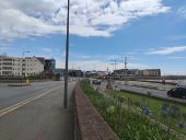
The A1 at its underpass in St. Helier, Jersey heading towards the Tunnel (A17). Taken from the Port Roundabout. The road here frequently gets backed up in the centre lane with traffic heading through the bottleneck S1 to the east. Ahead a unique 'Allow buses to merge' can be seen, buses will come down the slip road to the left and need to be in the centre lane to travel east through the Tunnel.
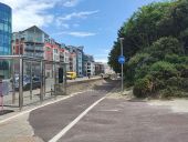
A newly opened segregated cycle track alongside the A1. This used to run along the section of pavement on the left as a line-seperated shared use track, but this new track was opened last year to speed up journeys through the town by bike.
A view over the A1 and A2 of Jersey heading east towards 'the Tunnel'. The 'West Park roundabout' forms the junction of the B87 St Aubin's Road, A1 Route de Saint Aubin and A1 unnamed link road. The clockwise St Helier Ring Road travels eastbound up the link road and takes a right turn at the roundabout onto the B87. From the link road, vehicles cannot move from the A1 link road to/from the A2 Victoria Avenue; although there is no prohibited movements, the movement would be practically impossible due to the junction. This junction is soon to be reconstructed as part of the Overdale Hospital works.
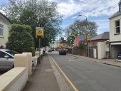
The B82 St Mark's Road in Springfield, St Helier, Jersey. This forms part of the anti-clockwise St Helier Ring Road, the entirety of which has a 30mph limit, apart from this section, which has a 20mph limit during school drop-off and pick-up times. The flashing lights are controlled by the school and when illuminated create an enforceable 20mph limit from this sign until the end of 20 zone sign around the corner. The signs are yellow-backed, and the text 'when lights flash' is not in a white-backed box. This road is one-way, and forms the Southern arm of a gyratory.
Hidden categories: