Star grey.pngStar grey.pngStar grey.pngStar grey.pngStar grey.png

Gravelye Lane Junction

From Roader's Digest: The SABRE Wiki
Jump to navigation Jump to search
Gravelye Lane Junction
Location Map ( geo)
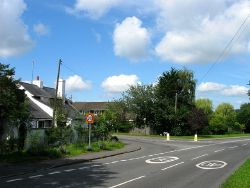
Greyfriars, Gravelye Lane, Lindfield - Geograph - 4618995.jpg
Cameraicon.png No pictures uploaded (Upload?)
Location
Haywards Heath
County
Sussex
Highway Authority
West Sussex
Junction Type
t junction
Roads Joined
B2111


Route To Notes

B2111

Scaynes Hill Road

B2111

Lewes Road
Gravelye Lane


Gravelye Lane Junction
Other nearby junctions
Haywards Heath
Junctions Haywards Heath
A272 (In Haywards Heath)Tylers Green Roundabout • Chownes Mead Junction • Bolnore Roundabout • Lower Village Roundabout • Highbank Roundabout • Sandrocks Roundabout • Foxhill Roundabout • The Birch Hotel Roundabout • Bedales Corner
B2272Tylers Green Roundabout • Butlers Green Junction • Sergisons Arms Roundabouts • Muster Green Gyratory • Sussex Square • The Princess Royal Hospital Roundabout • The Birch Hotel Roundabout
B2111High Street Junction (Lindfield) • Gravelye Lane Junction • East Mascalls Lane Junction • Bedales Corner
B2028 (In Haywards Heath)High Street Junction (Lindfield) • Backwoods Lane Roundabout • Scrace Bridge Roundabout • Commercial Square • Muster Green Gyratory
B2112 (In Haywards Heath)Scrace Bridge Roundabout • New England Road Junction • Sussex Square • Foxhill Roundabout • Fox and Hounds Inn Junction


SABRE - The Society for All British and Irish Road Enthusiasts
Discuss - Digest - Discover - Help