Hardwick Roundabout
| Hardwick Roundabout | |||
| Location Map ( geo) | |||
 | |||
| Traffic signals on the main roundabout's circulatory carriageway, with the flyover in the background carrying the A47 over the junction | |||
| |||
| Location | |||
| Hardwick, King's Lynn | |||
| County | |||
| Norfolk | |||
| Highway Authority | |||
| National Highways | |||
| Junction Type | |||
| Signalised Roundabout with flyover and satellite roundabout | |||
| Roads Joined | |||
| A10, A47, A149 | |||
For the interchange on the A428 west of Cambridge, see Hardwick Interchange.
For the gyratory between the A40, A465 and A4042 near Abergavenny, see Hardwick Gyratory.
Description

Hardwick Roundabout, or Hardwick Interchange is the name of a primary route junction to the south-east of King's Lynn, in Norfolk. The A47 and the A149 cannon here, plus it serves as the northern terminus of the A10. With the A47 being a major route from the Midlands to East Anglia and the A10 being the main route to London, this is one of the busiest junctions in the area.
History
Before the 1970s, this used to be a simple fork, linking the route from Norwich into King's Lynn (present day A47 eastbound to the A149 westbound) and the route to Cambridge and Ely (present day A10) meeting here. In 1922, the A17 forked off the A10, which went into the centre of the town. After 1935, the A47 took over the east-west route.
The Hardwick Roundabout itself came into being in the 1970s when King's Lynn's southern bypass and A149 eastern bypass were constructed and met at this junction. Provision was made for the A47 to fly over the top, with the western A47 flaring down to the junction, and a mound of earth in the middle of the junction. Part-time traffic signals were added to the junction as the route became significantly busier.
Finally in the early 2000s the flyover was constructed, but not as originally envisioned. The mound of earth was removed, and a single carriageway flyover constructed with a 40 mph speed limit. The flares on the westernt A47 remain as sliproads, but a roundabout (officially called 'Constitution Hill Roundabout', but known locally as 'Hardwick Satellite Roundabout') was built on the eastern A47 to provide access to the other side of the junction. At the same time, the lanes were reconfigured and the part-time lights converted to be full-time.
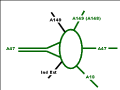
Hardwick Roundabout, 1970s - 1990s
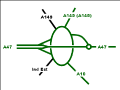
Hardwick Roundabout as it is today


The above image of the 70s - 90s doesn't quite show the full picture - there was a one way sliproad to bypass the roundabout at the northern end between the Kings Lynn A149 and the bypass. This was removed when a new two way link road was built along with a new roundabout further north on the bypass - see Jubilee Roundabout.
Routes
| Route | To | Notes |
| Downham Market, Thetford (A134) | ||
| Wisbech, Sleaford (A17), Saddlebow Ind Est | ||
| Norwich, Swaffham | ||
| Cromer (A148), Hunstanton, Sandringham, North Ind Ests, Docks, Hospital | ||
| King's Lynn, Hardwick Ind Est, Retail Park | ||
| Harwick Narrows Ind Est |
Links
legislation.gov.uk
- The A47 Trunk Road (Hardwick Roundabout Flyover and Slip Roads) Order 1996 - this seems to be an earlier incarnation of the scheme that ended up being built
- The A47 Trunk Road (Hardwick Roundabout to North Runcton) (Detrunking) Order 1996 - this removes trunk status from a section of the A47 bypassed by the improvements above
- The A47 Trunk Road (Hardwick Roundabout) Order 2001 - this appears to trunk some land adjacent and just north of the former A47 carriageway east of the roundabout

