Heathrow Airport
- See page B379 for information about country roads that existed until 1944 where the airport is now.
| Heathrow Airport | |||
| Location Map ( geo) | |||
 | |||
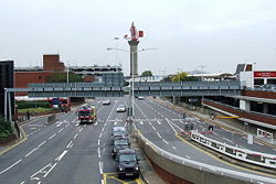
| These are the Airport roads and radar tower in the older part of Heathrow Airport | |||
| |||
| County | |||
| Middlesex | |||
| Opening Date | |||
| 1946 | |||
| Forward Destination on | |||
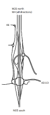
| M4, M25, A4, A30, A3113 | |||
| Next Primary Destinations | |||
| Hammersmith • Harrow • Hounslow • Slough • Staines • Watford | |||
| Other Nearby Primary Destinations | |||
| Uxbridge | |||
| Places related to the M4 | |||
Bridgend • Swindon • Swansea • Neath • Maidenhead • Cardiff • Newport • Reading • Slough • Port Talbot • Chippenham • Newbury • London • Brentford • Bristol | |||
| Places related to the M25 | |||
Swanley • Watford • Sevenoaks • Staines • Dartford • Reigate • Rickmansworth • Enfield • Brentwood • Potters Bar • Leatherhead • Orpington • Dartford Crossing • Waltham Abbey | |||
| Places related to the A4 | |||
Bristol • Maidenhead • Reading • Slough • Hounslow • Bath • Chippenham • Marlborough • Newbury • Avonmouth • The City • Central London • Hammersmith • West End • London • Hungerford • Brentford | |||
| Places related to the A30 | |||
Heathrow Airport is the world's fourth busiest airport, the busiest airport for international flights and by far the busiest in Europe. It was built at the latter end of World War 2 to be a civilian airport and grew quickly to be London's major airport. Despite efforts such as Gatwick Airport and various plans to build an airport in the Thames Estuary, Heathrow has been expanded several times, most notably with Terminal 5, which required the widening of the M25 between the M3 and M4, as well as a motorway spur to the new terminal. Plan exist for a third runway, which would put the M25 in a tunnel, add a collector-distributor set-up between junction 15 and a radically reworked junction 14.
Heathrow is also a major Primary Destination. It is the only Primary Destination other than London in Greater London that is typically signed from outside the M25.
Roads
The Airport proper is surrounded by Perimeter Roads (Northern, Western, Southern, Eastern) and other roads mostly begin with directional letters or 'C' for Central.
- N: Nene Road, Northwood Road, Northolt Road, Newton Road, Nelson Road, Newbury Road, Nettleton Road, Neptune Road, Newall Road, Northrop Road
- E: Eastchurch Road, Elgin Crescent, Enfield Road, Esher Crescent, Ely Road, Epsom Square, Envoy Avenue, Electra Avenue, Eagle Road, Elmdon Road, Earhart Way, Exeter Way
- S: Sheffield Way, Swansea Road, Shrewsbury Road, Snowdon Road, Scarborough Road, Swindon Road, Stratford Road, Seven Seas Road, Sealand Road, Stansted Road, Southampton Road, Shoreham Road, Stranraer Way, Seaford Road, Sandringham Road
- W: Woodcock Close, Whittle Road, Windsor Close, Wallis Road, Walrus Road, Wellington Road, Wayfarer Road, Wildcat Road, Widgeon Road, Wentworth Drive, Wilber Road, Warneford Road, Wasp Road, Wirra Way, Wagtail Road, Windsock Way
- C: Calshot Way, Croydon Road, Cranwell Road, Cromer Road, Cheddar Road, Courtney Way, Courtney Road, Camberley Road, Chipstead Road, Canberra Road, Cambourne Road, Cambourne Close, Cambourne Crescent, Chester Road, Contrail Way, Cessna Way, Constellation Way, Cosmopolitan Way, Clipper Way, Cayley Road, Condor Way, Cloud Way, Control Tower Road
Tunnels
Heathrow has several major road tunnels, though only the Heathrow Tunnel is open to the public. The Cargo Tunnel used to be, though now isn't. The Heathrow Airside Road Tunnel requires going through passport control and security to use.
Routes
| Route | To | Notes |
| Central London, Hammersmith, Hayes | ||
| The WEST, Reading, Slough | ||
| Oxford, Watford, Stansted Airport, (M40, M1, M11) | ||
| Staines, Gatwick Airport, Dartford (M3, M23, M20) | ||
| (M4), Slough | ||
| Central London, Hayes, Harrow, Hounslow | ||
| (M25), Staines | ||
| Central London, Hounslow | ||
| Simpson, Uxbridge, Yiewsley, Stockley Park | ||
| Harlington | ||
| West Drayton, Harmondsworth | ||
| Staines, Stanwell | ||
| (M25), Datchet |
Named Junction
Links


