Star.pngStar grey.pngStar grey.pngStar grey.pngStar grey.png

Holtye Crossroads

From Roader's Digest: The SABRE Wiki
Jump to navigation Jump to search
Holtye Crossroads
Location Map ( geo)
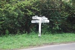
Old Direction Sign - Signpost - Geograph - 6037908.jpg
Fingerpost sign at junction
Cameraicon.png No pictures uploaded (Upload?)
Location
Holtye
County
Sussex
Highway Authority
East Sussex
Junction Type
Crossroads
Roads Joined
A264

Holtye Crossroads is a crossroads on the A264

Routes

Route To Notes

A264

East Grinstead Holtye Road

A264

Ashurst, Tunbridge Wells Holtye Common
Cowden Holtye Hill
Cansiron Lane, width restriction 6'6"


Holtye Crossroads
Junctions on the A264
Pembury to East GrinsteadPembury Interchange • Blackhurst Corner • Kingswood Road Junction • Calverley Crossroads • Keston Roundabout • Town Hall Crossroads • Church Road Crossroads • Mount Ephraim Junction • Bishops Down Roundabout • The Hare Crossroads • Crockers Hatch Corner • Langton Lodge Junction • Colestock Crossroads • Holtye Crossroads • Shepherds Grove Lane Junction • Shovelstrode Lane Junction • Blackwell Hollow Roundabout • Beeching Way Gyratory
East Grinstead to Horsham (Primary Route)Felbridge Junction • Crawley Down Road Junction • Snow Hill Junction • Dukes Head Roundabout • Borers Arms Road Junction • Copthorne Hotel Roundabout • Copthorne Way Roundabout • Crawley Interchange • Pease Pottage Interchange • Tollgate Hill Roundabout • Bewbush Manor Roundabout • Kilnwood Vale Roundabout • Faygate Roundabout • Roffey Roundabout • Rusper Road Roundabout • Langhurst Wood • Great Daux Roundabout
Horsham to Five OaksFarthings Hill Interchange • Newbridge Roundabout • High Wood Hill Interchange • Billingshurst Road Roundabout • Lyons Corner • Fulfords Hill Junction • Bashurst Hill Junction • Five Oaks Roundabout


SABRE - The Society for All British and Irish Road Enthusiasts
Discuss - Digest - Discover - Help