Star.pngStar.pngStar grey.pngStar grey.pngStar grey.png

Hunningham Bridge

From Roader's Digest: The SABRE Wiki
Jump to navigation Jump to search
Hunningham Bridge
Location Map ( geo)
Hunningham river bridge - Geograph - 1852498.jpg
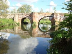
The Bridge in 2010
Cameraicon.png View gallery (1)
Location
Hunningham
County
Warwickshire
Highway Authority
Warwickshire
Opening Date
Mid C17
Additional Information
List No:  1005770  (Grade II)
Bridge Type:  Arch Bridge

Hunningham Bridge carries a minor road across the River Leam in Hunningham, Warwickshire. It is a stone arch bridge built in mid 17th Century.


The bridge is a scheduled monument, and English Heritage's Heritage at Risk Register states that it is grade II listed. It appears on the At Risk Register as a result of damage from repeated vehicle impacts[1]. The bridge was repaired following two vehicle impacts in 2015, but was damaged again shortly afterwards.

References


Hunningham Bridge
Related Pictures
View gallery (1)
Hunningham river bridge - Geograph - 1852498.jpg
Crossings of the River Avon and Tributaries
AvonWelford Bridge • A14 Bridge • M1 Catthorpe Viaduct • Dow Bridge • Old A426 Bridge • Rugby Western Relief Road Bridge • Bretford Bridge • Ryton Bridge • Stare Bridge • Chesford Bridge • Portobello Bridge • Castle Bridge (Warwick) • M40 Longbridge • Barford Bypass Bridge • Clopton Bridge • Seven Meadows Bridge • Bidford-on-Avon Bridge • Simon de Montfort Bridge • Abbey Bridge (Evesham) • Pershore Bridge • Eckington Bridge • M5 Bredon Bridge • Beaufort Bridge
LeamAdelaide Bridge • Victoria Bridge • Willes Bridge • Hunningham Bridge • Marton Bridge • Birdingbury Bridge • Thurlaston Bridge • Miry Bridge


SABRE - The Society for All British and Irish Road Enthusiasts
Discuss - Digest - Discover - Help