Inverlael Bridge
| Inverlael Bridge | |||
| Location Map ( geo) | |||
 | |||
| |||
| From: | Braemore Junction | ||
| To: | Ullapool | ||
| Location | |||
| Inverlael | |||
| County | |||
| Ross-shire | |||
| Highway Authority | |||
| Transport Scotland | |||
| Opening Date | |||
| 1792, 1964 | |||
| On road(s) | |||
| A835 | |||
| Crossings related to the A835 | |||
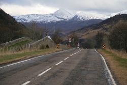
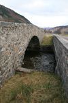
The River Lael flows into the head of Loch Broom alongside the River Broom at Inverlael, and drains a large mountainous area to the north east. It is crossed by the road from Dingwall to Ullapool, which was built between 1792 and 1794, and so the old bridge at Inverlael presumably dates from this time. The old bridge is a single humpbacked stone arch similar to the bridges built as part of the military roads further south in the Highlands fifty years earlier. However, as far as is known no military road ever came this far north. The bridge carried a single carriageway between low parapets which extend some distance to either side. Some notes on the bridge suggest that the approaches have been levelled, but there is no obvious evidence of this on the ground.
The new bridge sits directly alongside to the south, and was built in 1964 to carry a new S2 road parallel to the old. It too is a single span, albeit a concrete deck between rubble parapets and abutments, perhaps designed to fit in with the old bridge alongside.
| Inverlael Bridge | ||
|


