Star.pngStar grey.pngStar grey.pngStar grey.pngStar grey.png

Killington New Bridge

From Roader's Digest: The SABRE Wiki
Jump to navigation Jump to search
Killington New Bridge
Location Map ( geo)
Killington New Bridge - Geograph - 1202250.jpg
Cameraicon.png View gallery (1)
From:  White Hall
To:  Four Lane Ends
Location
3 miles SW of Sedbergh
County
Westmorland • Yorkshire
Highway Authority
Westmorland and Furness
On road(s)
B6256

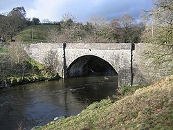
Killington Bridge crosses the River Lune, which here forms the border between Westmorland and Yorkshire, some 3 miles SW of Sedbergh.


Killington New Bridge
Related Pictures
View gallery (1)
Killington New Bridge - Geograph - 1202250.jpg
Crossings of the River Lune
Low Lane Bridge • Raisgill Hall Bridge • Tebay Bridge • M6 - Tebay Bridge • M6 - Tebay Bridge (2) • M6 - Lune Valley Viaduct • M6 - Lune Valley Viaduct(2) • Lincolns Inn Bridge • Killington New Bridge • Devil's Bridge • Stanley Bridge • Lune Bridge • Lune West Bridge • Skerton Bridge • Greyhound Bridge


SABRE - The Society for All British and Irish Road Enthusiasts
Discuss - Digest - Discover - Help