Kilsby Interchange
| Kilsby Interchange | |||
| Location Map ( geo) | |||
 | |||
| |||
| Location | |||
| Kilsby | |||
| County | |||
| Northamptonshire | |||
| Highway Authority | |||
| National Highways | |||
| Junction Type | |||
| Fork | |||
| Roads Joined | |||
| M1, M45 | |||
| Junctions related to the M45 | |||
The Kilsby Interchange, junction 17 of the M1, is the junction between the M1 and M45. It was built in 1959 and is the oldest motorway-to-motorway junction in the country (now that the M10 has been downgraded).
It is a south facing fork junction, a legacy of when the M1 ended a few miles north of here.
The advance signage for this junction originally had a fork offering "M45" and "M1" as exits, which caused confusion as the M1 was known informally (and inaccurately) as the motorway to Birmingham, but until the M6 opened, the M45 exit was needed. Some debate was held about the best way to handle junctions like this, as there were about to be more junctions like this. Equally on the southbound side, engineers weren't sure how to explain to motorway-novice motorists how to use the merge, exploring a range of complicated diagrams and wordy "stay in lane - traffic islands ahead" messages.
Strip Maps
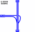
The current layout of the interchange.

Routes
| Route | To | Notes |
| The NORTH, Birmingham (M6) | ||
| The SOUTH, Northampton, London | ||
| Coventry |


