Kylesku Bridge
| Kylesku Bridge Drochaid a' Chaolais Chumhaing | |||||||
| Location Map ( geo) | |||||||
 | |||||||
| From: | Kylesku | ||||||
| To: | Kylestrome | ||||||
| County | |||||||
| Sutherland | |||||||
| Highway Authority | |||||||
| Highland | |||||||
| Additional Information | |||||||
| |||||||
| On road(s) | |||||||
| A894 | |||||||
| Crossings related to the A894 | |||||||
| Crossings related to the North and West Highlands Route | |||||||
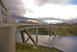
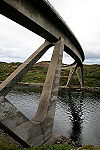
The Kyslesku Bridge in the north-west of Scotland carries the non-trunk A894 across Loch a' Chàirn Bhàin between Unapool and Kylestrome. Designed by Ove Arup and built by Morrisons for the then Highland Regional Council, it was opened by the Queen in 1984, to replace the old ferry further east. The bridge is a concrete structure supported by dramatic, open inclined legs spreading out from a pair of foundation points on either side of the channel, like four edges of a tetrahedron. These legs also splay out to either side of the bridge deck, so that the foundation points are wider apart than the deck, and are shaped so as to be quite slender in profile, but wider in cross section.
The bridge therefore spans the narrow entrance to the loch with a single main span, two subsidiary spans between the arms of the pier supports and a further two spans before the land is reached at either end. The bridge is built on a sweeping curve, which adds to the drama when set against the spectacular backdrop of mountains. It is little wonder that this is one of the most photographed bridges in Scotland, and often features in corporate documents relating to Scotland.
Causeway
To the north, the bridge makes land fall on the island of Garbh Eilean. Therefore, in order to connect back to the old line of the A894, it has to cross a deep rocky gash in the island itself, which appears to have been tidal in the past, and then a rocky beach back to the mainland. The first crossing is by a high embankment of rock fill piled into the chasm, which is only loosely described as a causeway. However, the second crossing was undoubtedly built as a causeway by piling rocks onto the beach to carry the road. However, the inland side of the causeway appears to have silted up in the last 40 years, and is now almost completely dry at low tide.
Ferry
Before the bridge was opened, a shuttle ferry ran across the narrow channel. This crossing was probably operated for centuries, but was formalised when the two ferry slips were first built. This probably happened in the 1820s or 1830s when the road was built, and it seems likely that the engineer responsible was Joseph Mitchell, who was county surveyor for Sutherland at the time. In the 1960's the ferry was able to carry 4 cars, took 5 minutes to cross and was free. It operated from 9am until 9pm in the summer, and dusk in the winter months. It was not until 1975 that a ferry large enough to carry modern HGVs was introduced, all previous ferries having weight limits and size restrictions.
Ferries
| Name | IMO | Operator | Dates | Notes |
|---|---|---|---|---|
| Maid of Glencoul | 7521613 | Highland Council | 1975-84 | 18 Cars |
| Glenachulish | Highland Council | 1976-82 (relief only) | 6 Cars - No IMO MarineTraffic | |
| Queen of Kylesku | Sutherland CC; Highland Council | 1967-84 | 6-9 Cars | |
| Mamore | Sutherland CC | 1959-67 | 4 Cars | |
| Maid of Kylesku | Sutherland CC | 1952-76 (Relief only after 1967) | 4 Cars | |
| Un-named | Scottish Automobile Association; Sutherland CC | c1920-52 | 1 Car |
| Kylesku Bridge | ||
|


