Laughanstown Interchange
Jump to navigation
Jump to search
| Laughanstown Interchange Acomhal Bhaile an Locháin | |||
| Location Map ( geo) | |||
 | |||
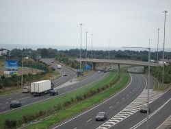
| Looking north-west from the M50. | |||
| |||
| Location | |||
| Laughanstown | |||
| County | |||
| Dublin | |||
| Highway Authority | |||
| Transport Infrastructure Ireland | |||
| Junction Type | |||
| Diamond | |||
| Opening Date | |||
| 2005 | |||
| Roads Joined | |||
| M50, R118 | |||
The Laughanstown Interchange (sometimes referred to as Cherrywood) is junction 16 of the M50.
It is a diamond interchange linking to the R118, which serves the expanding Cherrywood area of Dublin.
It was opened in June 2005 as a new proposal that was not mentioned in any of the original South East Motorway plans.
Routes
| Route | To | Notes |
| Ó Dheas SOUTHBOUND | ||
| Ó Thuaidh NORTHBOUND | ||
| An Baile Breac BALLYBRACK · Baile Uí Lachnáin LOUGHLINSTOWN · An Naigín SALLYNOGGIN · Dún Laoghaire |
| Laughanstown Interchange | ||
| ||
|


