Star.pngStar grey.pngStar grey.pngStar grey.pngStar grey.png

Liphook Interchange

From Roader's Digest: The SABRE Wiki
Jump to navigation Jump to search
Liphook Interchange
Location Map ( geo)
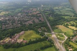
A3 junction at Bramshott- aerial 2015 - Geograph - 4526017.jpg
Aerial photograph of the junction
Cameraicon.png View gallery (1)
Location
Bramshott
County
Hampshire
Highway Authority
National Highways
Junction Type
Folded Diamond
Roads Joined
A3, B2131

Routes

Route To Notes

A3

Portsmouth, Petersfield

A3

London, Guildford, Waggoners Wells

B2131

Liphook 1/2, Haslemere 5, Bordon
St Mary's Church, Bramshott 1/4


Liphook Interchange
Related Pictures
View gallery (1)
A3 junction at Bramshott- aerial 2015 - Geograph - 4526017.jpg
Junctions on the A3
Bank • Monument • Borough • Elephant & Castle • Kennington Oval • Clapham Common • Wandsworth Gyratory • Tibbets Corner • Roehampton Lane • Stag Lane • Robin Hood • Coombe Lane • Shannon Corner • Malden Corner • Tolworth • Hook • Esher Common • Painshill • Wisley • Ockham Park • Send • Burpham • Stoke • Wooden Bridge • University • Hogs Back • Compton • Shackleford • Milford • Thursley • Hazel Grove • Liphook • Griggs Green • Longmoor • Ham Barn Roundabout • Flexcombe • Sheet • Berelands • Weston • QE Country Park • Clanfield • 1 London Road • 2 Hazelton • 3 Hulbert Road • 4 Purbrook Way • 5 Bedhampton Roundabout • Broad Marsh • Spur Road Roundabout • Paulsgrove • Portsbridge Roundabout • Rudmore • Church Street Roundabout • Cambridge Junction

SABRE - The Society for All British and Irish Road Enthusiasts
Discuss - Digest - Discover - Help