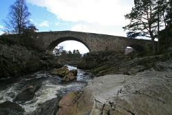
Little Garve Bridge
| Little Garve Bridge | |||||
| Location Map ( geo) | |||||
 | |||||
| From: | Strath Garve | ||||
| To: | Little Garve | ||||
| Location | |||||
| Little Garve | |||||
| County | |||||
| Ross-shire | |||||
| Highway Authority | |||||
| Highland | |||||
| Opening Date | |||||
| 1762 | |||||
| Additional Information | |||||
| |||||
The bridge at Little Garve was constructed by Major Caulfeild in the 1762 as part of the governments military roads which were built in the wake of the Jacobite Rebellion in 1745/6. This particular route ran from Contin north west to Poolewe, and while the route to the north of the bridge is easily traced, that to the south is a little more difficult, although the forest road from Strath Garve to Contin may be on the same alignment.
The bridge has never been part of a classified road, with the route followed by the A835 already having been built prior to classification in 1922. However, the road over the bridge was in use until 1987 when it was finally decided that bridge was in too poor condition for continued use. However, it took another 20 years before restoration work took place, following a partial (minor) collapse a couple of years before.
The Bridge
The bridge is a single span hump-backed stone arch, similar to many other constructed by Wade and Caulfeild throughout the HIghlands. There is also a very small flood arch on the northern bank. The bridge site makes use of a narrow part of the roc cut river channel of the Black Water, the arch springing from bedrock projections that are higher and closer than at any other point nearby - an ideal spot!
The southern approach to the bridge is curved southwards to meet the end of the long straight from Strath Garve. The carriageway across the bridge is single carriageway, humped to reduce visibility and now blocked by two large stone cubes at either end, leaving just enough room for pedestrians and cyclists to cross.
| Little Garve Bridge | ||||||||||
| ||||||||||
|


