London Bridge (Dublin)
Jump to navigation
Jump to search
| London Bridge | |||
| Location Map ( geo) | |||
 | |||
| |||
| Location | |||
| Irishtown | |||
| County | |||
| Dublin | |||
| Highway Authority | |||
| Dublin City | |||
| Additional Information | |||
| |||
| On road(s) | |||
| R111 | |||
| Crossings related to the R111 | |||
This article is about the bridge in Irishtown, Dublin.
For other bridges with the same name, see London Bridge (disambiguation).
For other bridges with the same name, see London Bridge (disambiguation).
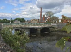
London Bridge in Dublin is a triple-arch cut-stone bridge crossing the River Dodder. It is an old and narrow structure, with only a single, alternating line of traffic able to use it at one time.
The bridge carries the R111, which is named Londonbridge (no space). This formed an important route between Dublin Port and the routes to the south-west, but its narrow width and the low bridge further down the road meant it wasn't particularly suited to this task. Since the opening of Samuel Beckett Bridge in 2009, London Bridge has been relieved of its status of being on the Dublin Outer Orbital Route.
The height of the bridge barriers was raised considerably in 2010, as part of flood alleviation works.
| London Bridge (Dublin) | ||
| ||
|


