Star.pngStar.pngStar grey.pngStar grey.pngStar grey.png

Chalton Interchange

From Roader's Digest: The SABRE Wiki
(Redirected from M1 J11A)
Jump to navigation Jump to search
Chalton Interchange
Location Map ( geo)
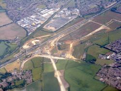
Roadworks for a link to the M1 from the west - Geograph - 4547167.jpg
Cameraicon.png View gallery (2)
Location
Chalton
County
Bedfordshire
Highway Authority
National Highways
Junction Type
dumbbell
Roads Joined
M1, A5, A5505

Chalton Interchange is Junction 11A on the M1 north of Luton. It opened on the 10th of May 2017, to serve the Dunstable Northern Bypass and Woodside Link. A link to the A6 is proposed.

Routes

Route To Notes

M1

The NORTH, Bedford (A421)

M1

London, Luton

A5

Milton Keynes, Aylesbury (A505)

A5505

Dunstable, Houghton Regis Woodside Link

A6

Bedford, Luton (N), Barton-le-Clay provision created for a link to the A6[1]

B579

Chalton, Leagrave proposed direct link to the B579 rejected by National Highways during planning

References

Links

legislation.gov.uk


Chalton Interchange
Related Pictures
View gallery (2)
M1 Junction 11a - Coppermine - 11062.jpgRoadworks for a link to the M1 from the west - Geograph - 4547167.jpg
Other nearby junctions
Luton
Dunstable
Junctions on the M1
Marble Arch • Hampstead • 1 Staples Corner • 2 Fiveways • Scratchwood • 4 Brockley • Bushey • 5 Berrygrove • 6 Waterdale • 6A Chiswell • 7 Beechtrees • 8 Breakspears • 9 Friars Wash • 10 Pepperstock; (10A Kidney Wood) • 11 Junction 11 • 11A Chalton • 12 Toddington • 13 Ridgemont • 14 Broughton • 15 Collingtree • 15A Rothersthorpe • 16 Kislingbury • 17 Kilsby • 18 Crick • 19 Catthorpe • 20 Misterton • 21 Whetstone • 21A Kirby Muxloe • 22 Markfield • 23 Shepshed • Long Whatton • 23A Finger Farm • 24 Kegworth • 24A Warren Lane • 25 Sandiacre • M42 • 26 Nuthall • 27 Junction 27 • 28 Pinxton • 29 Heath • 29A Duckmanton • 30 Barlborough • 31 Aston • 32 Thurcroft • 33 Catcliffe • 34 Tinsley • 35 Thorpe Hesley • 35A Tankersley • 36 Birdwell • 37 Dodworth • 38 Haigh • 39 Durkar • 40 Flushdyke • Kirkhamgate • 41 Carrgate • 42 Lofthouse • 43 Belle Isle • 44 Rothwell Haigh • 45 East Leeds Link • 46 Austhorpe • 47 Parlington • 48 Hook Moor
Former Leeds city section: 43 Stourton • 44 Belle Isle • 45 Tunstall • 46 Hunslet • 47 Holbeck
Junctions on the A5
London - CrickMarble Arch • Marylebone Flyover • Staples Corner • Canons Corner • Brockley • Elstree Crossroads • Park Street • King Harry • Peahen Crossroads • Friars Wash • Dunstable Crossroads • Chalk Hill Rdbt • M1 Junction 11A • Thorn Rdbt • Hockliffe Crossroads • Sheeps Lane Rdbt • Little Brickhill • Caldecotte • Redmoor • Portway • Abbey Hill • Old Stratford Rdbt • Tove Rdbt • Weedon Crossroads • Watford Crossroads • Kilsby • Halfway House Rdbt • DIRFT Rugby North Rdbt
Crick - TamworthCrick • DIRFT Rugby East Rdbt • DIRFT Rugby North Rdbt • Gibbet Rdbt • Cross in Hand • High Cross • Smockington Hollow • Stretton Baskerville • Sketchley Rdbt • Dodwells Rdbt • Longshoot • Higham Rdbt • Red Gate • Mancetter Rdbt • Holly Lane Rdbt • Grendon Rdbt • Dordon Rdbt • M42 Junction 10
Tamworth-TelfordM42 Junction 10 • Centurion • Glascote • Ventura Park • Mile Oak • Weeford • Wall Island • Muckley Corner • Rising Sun • The Turf • Churchbridge • Wynn's Corner • Longford Island • Gailey Interchange • Gailey Island • Pickmere Roundabout • Limekiln Bank Rdbt • Priorslee Rdbt • Priorslee Interchange • Hollinswood
Telford-OswestryHollinswood • Forge • Cluddley • Preston Island • Emstrey Island • Bayston Hill Rdbt • Edgebold Rdbt • Woodcote Rdbt • Churncote Rdbt • Felton Butler Rdbt • Wolfshead Rdbt • Queens Head Junction
Oswestry-HolyheadQueens Head Junction • Mile End Rdbt • Whittington Rdbt • Five Crosses • Gledrid Rdbt • Halton Rdbt • Whitehurst Rdbt • Llys y Gwynt • Antelope Rdbt • Anglesey Arms • Carreg Bran • Glan Menai • Nant Turnpike • Dalar Hir • Caergeiliog

SABRE - The Society for All British and Irish Road Enthusiasts
Discuss - Digest - Discover - Help