M25/Technical

This page outlines other technical information of note, such as chainage and street lighting.
Distance and markers
The M25 is widely accepted to be 117 miles (188.3 kilometres) long.[1][2]
The lowest and highest numbered distance markers are on the A282, at the clockwise entrance to the Dartford Crossing Control on the north side of the Thames. They are km 2.1 and km 187.4 respectively,[3][4] although some equipment are marked up to km 187.7.[5] This gives a total signed chainage of 185.3 kilometres, which would technically place km 0.0 (signed as km 185.3)[6] just under the northern bridge of the Mar Dyke Interchange.
Emergency access connections
Most of the connections are gated to deter misuse.
| Location | km | |
|---|---|---|
| A | B | |
| London Road, near Fort Halstead | 24.2 | — |
| Hogtrough Hill and Station Road, near Brasted | 29.2 | 29.4 |
| Palmer’s Moor Lane, near Iver | 98.5 | |
| Fulmer Lane and Pinstone Way, north of Denham Interchange | 103.5 | 103.6 |
| Coldharbour Farm | 106.0 | |
| West of Theydon Bois Interchange | 158.2 | |
| Mount Road, East of Theydon Bois Interchange | 162.3 | |
Emergency access connectors also exist on the slip roads of the Theydon Bois Interchange, which can also be improvised as a diversion if the main carriageway is blocked.
Signage
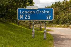
A number of entrances to the M25 use a variant of the Chopsticks sign (drawing P2901) with the “London Orbital” header, most of which date from the completion of the M25 in 1986. No version of the Traffic Signs Regulations and General Directions have supported this variant, and it is unclear if a special authorisation existed at the time: newer signs simply use the route number.
As of 2022, you can still find such signs at the following entrances:
- Junctions 18, 25 and 29 (clockwise only)
- Junctions 17, 24 and 26 (anticlockwise only)
Due to widening works, the “London Orbital” signs at Junctions 20 and 21A were replaced by a standard design in June 2011, followed by those on Junction 22 in May 2012. The clockwise sign on Junction 26 was damaged sometime between 2018 and 2020, and was also replaced by a standard design.
Street lighting
The M25 has many sections with street lighting, although the location of such sections have changed over time. The Philips MA series of low pressure sodium lanterns used to be the dominant model in use, supplemented by catenary lighting around junction 12 (km 82.9–84.6) and junctions 13–15 (km 87.7–km 95.0). They were gradually replaced by various models of high pressure sodium lanterns, such as the Philips Iridium, Philips Trafficvision, Schréder Sapphire and Urbis ZX3.
A short section of LED lighting (using CU Phosco P860) was recently installed as part of a temporary junction for the construction of High Speed 2 (km 108.0 to km 108.4), and have slowly started to replace both low and high pressure sodium lanterns.
In 2001, street lighting (on the main carriageway) covered the following sections (in clockwise direction unless indicated):
| Start | End | Notes | ||
|---|---|---|---|---|
| km | Description | km | Description | |
| 133.3 | Blanche Lane Overbridge, west of junction 23 | 9.5 | Hawley Road underbridge, south of junction 2 | Via the Dartford Crossing. |
| 24.7 | Gantry 4248J, between the Morants Court Road overbridge and junction 5 | 27.8 | Marker between the Chevening Road and Coombe Bank Drive overbridges, west of junction 5 | Carriageways A/B. |
| 26.9 | Footbridge 26 2/3, south of junction 5 | Carriageways J/L towards the A21. | ||
| 42.0 | Footbridge over the western slip roads of junction 6 | 104.2 | Gantry 5041B (anti-clockwise),[7] north of junction 16 (now removed) | Longest section, at the time around 63.2 kilometres. |
| 112.1 | Northern end of a viaduct over the Metropolitan line, south of junction 18 | 124.6 | Marker between the Lye Lane and Park Street Lane overbridges, east of junction 21A | Excludes the spur to Hunton Bridge. |
In September 2020, street lighting covered the following sections:
| Start | End | Notes | ||
|---|---|---|---|---|
| km | Description | km | Description | |
| 156.5 | Traffic camera 156/5B (anti-clockwise), west of Bell Common Tunnel | 13.2 | A marker, north of junction 3 | Via the Dartford Crossing. |
| 24.7 | Gantry 4248J, between the Morants Court Road overbridge and junction 5 | 27.6 | A marker, between the Chevening Road and Coombe Bank Drive overbridges, west of junction 5 | Carriageways A/B. |
| 26.9 | Footbridge 26 2/3, south of junction 5 | Carriageways J/L towards the A21. | ||
| 42.0 | Footbridge over the western slip roads of junction 6 | 135.5 | A marker east of junction 23 | Longest section, now around 98.4 kilometres; excludes the spur to Hunton Bridge. |
| 137.1 | A marker west of junction 24 | 139.5 | Traffic camera 139/5A (clockwise),[8] east of junction 24 | The traffic camera is accessible via Traffic England. |
| 146.0 | A marker west of junction 25 | 148.5 | Western end of a bridge over the West Anglia line, west of the Holmesdale Tunnel | |
| 151.6 | A marker west of junction 26 | 154.0 | A marker (clockwise) or tourist sign (anti-clockwise), east of junction 26 | |
Traffic management
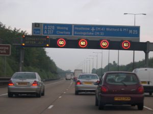
The M25 was one of the first motorways to adopt Variable Speed Limits (VSL), a precursor to the current Smart Motorway system. They are recognisable by the use of red rings for speed limits, in place of flashing amber lamps.
The Highways Agency introduced VSLs between junction 10 and junction 15, in August 1995. The system, known at the time as Controlled Motorways, was originally based on historical traffic data, but driver complaints brought forward plans to use actual traffic flows instead of historical data. VSLs were supplemented by Enhanced Message Signs, introduced in stages from October 1998 to July 1999.[9]
Today, the remaining sections of the London Orbital without VSLs are:
- Between junctions 3 and 5
- The Hunton Bridge spur at junction 19
- The A282 between junctions 30 and 2 (via the Dartford Crossing)
References


