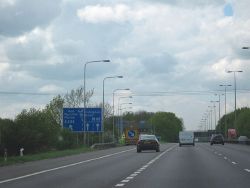
Handy Cross Interchange
| Handy Cross Interchange | |||
| Location Map ( geo) | |||
 | |||
| |||
| Location | |||
| Handy Cross, nr High Wycombe | |||
| County | |||
| Buckinghamshire | |||
| Highway Authority | |||
| National Highways | |||
| Junction Type | |||
| Modified Roundabout Interchange | |||
| Roads Joined | |||
| M40, A404, A4010 | |||
| Junctions related to the A4010 | |||
Handy Cross Interchange is junction 4 of the M40. The junction was upgraded during 2006 (opening 2007) by adding a cut-through, a left turn slip and widening the M40 offslips, to allow easier access to and from the trunk A404 to the south of the junction.
However in 1993 a more ambitious scheme was proposed as part of plans to widen the M40 to dual 4 lanes. Two options were available, online widening with improvements to the existing junction or a new M40 alignment to the south along with a new freeflow junction. The second option was supported by both Buckinghamshire County Council and Wycombe District Council who saw a potential use of the existing M40 alignment for a new link road around the south of High Wycombe. The Department for Transport agreed to this and the scheme went out to consultation but was eventually scrapped.
Routes
| Route | To | Notes |
| London, (M25) | ||
| Birmingham, Stokenchurch, Oxford | ||
| (M4), Marlow (A4155), Maidenhead (A4) Reading, Slough lorry routes. |
on gantries as Reading, Slough, Marlow, (M4). M4 to Reading and Slough via A404(M) | |
| Aylesbury | Cressex Business Park, Sands, Booker, Park and Ride for Town centre and Adams Park | |
| Wycombe, Sports Centre | ||
| Marlow Bottom | ||
| Marlow Road. Goes to Cressex and Business Park, but now unsigned | ||
| Oxford, Stokenchurch | ||
| London, Beaconsfield |
Links
- Roads.org.uk:Bad Junctions
- Legislation - The M40 Motorway Junction 4 (Handy Cross) Connecting Road Scheme 2005 - Orders for the 2006 junction improvement


