Star.pngStar.pngStar.pngStar grey.pngStar grey.png

Gailey Interchange

From Roader's Digest: The SABRE Wiki
(Redirected from M6 J12)
Jump to navigation Jump to search
Gailey Interchange
Location Map ( geo)
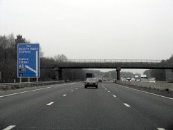
M6 Motorway - Junction 12 Exit, Northbound - Geograph - 1677445.jpg
M6 J12 Exit, Northbound
Cameraicon.png View gallery (7)
Location
Gailey
County
Staffordshire
Highway Authority
National Highways
Junction Type
Roundabout interchange
Roads Joined
M6, A5
This article is about the junction between A5 and M6 to the north of Wolverhampton.
For the often confused junction between A5 and A449 to the west, see Gailey Island
.
The eastern side of the roundabout

Gailey Interchange is a roundabout interchange located to the north of Wolverhampton and west of Cannock, Staffordshire, and is junction 12 of the M6 motorway.

For southbound traffic, it is the northernmost exit for both Wolverhampton and Cannock, whilst for northbound traffic it is signed for Telford, though the majority of traffic from the south will have exited at junction 10A and used M54.

Whilst known as Gailey Interchange, it is named after the hamlet of Gailey a mile or so to the west, and is rather confusingly similar to Gailey Island, which is the junction of A5 and A449 in the hamlet itself.

The junction is unchanged from its original opening in March 1966.

It has the alternative name of Calf Heath Roundabout (used by Staffordshire County Council), despite being some way and not directly accessible from the village of Calf Heath. It is exclusively locally known as Gailey Interchange however.

The junction under construction in 1965
The 1969 OS One Inch map showing the junction's original layout
For a short period in 1966, the junction was a temporary terminus of M6

Routes

Route To Notes

M6

The NORTH WEST, Stafford

M6

The SOUTH, The SOUTH WEST (M5), (M6 Toll), Birmingham

A5

Telford (M54), Telford, Shrewsbury, W'ton (A449)

A5

Cannock, Brownhills


Gailey Interchange
Related Pictures
View gallery (7)
M6 J12 sign.jpgA5 Roundabout at the M6 - Geograph - 3840995.jpgM6 Motorway - Junction 12 Exit, Northbound - Geograph - 1677445.jpgM6 J12 heading northbound - Coppermine - 17483.JPGM6 J12 heading northbound - Coppermine - 17484.JPG
Other nearby junctions
Wolverhampton
Anson Junction • Battlefield Roundabout (Wolverhampton) • Bentley Bridge Island • Bentley Interchange • Bentley Junction • Bilston Street Island • Bowmans Harbour Island • Broad Street Junction • Bull Ring (Sedgley) • Bull Ring (Willenhall) • Bull Stake • Bushbury Island • Chapel Ash Island • Coseley Road Island • Coven Heath Interchange • Coven Roundabouts • Elephant and Castle (Wolverhampton) • Essington Interchange • Featherstone Interchange • Fighting Cocks • Five Ways (Dunstall Park, Wolverhampton) • Five Ways (Merry Hill, Wolverhampton) • Five Ways (Wolverhampton City Centre) • Five Ways (Wolverhampton) • Fordhouses Roundabout • Four Ashes Junction • Fox Crossroads • Gailey Island • Goodyear Island • Horseley Fields Junction • Keyway Junction • Laney Green Interchange • Leicester Square (Wolverhampton) • Lloyd Hill Roundabout • Merrills Hall Island • Midland Counties Dairy • Moxley Junction • Neachells Lane Island • New Cross Junction • New Invention Island • Oxford Street Island • Penn Road Island • Pickmere Roundabout • Portobello Island • Princes Square • Queen Square (Wolverhampton) • Saredon Interchange • Short Heath Interchange • Snow Hill Junction (Wolverhampton) • Spring Vale Island • St Peters Square • Stafford Place • Stafford Street Junction • Standeford Crossroads • The Dale • The Lunt Junction • Scotlands Island • Three Tuns Junction • Tong Interchange • Victoria Square • Vine Island Junction • Vulcan Road Island • Waterloo Road Junction • Western Way Interchange • Wood End Island
Cannock
Junctions on the M6
PresentM1 J19 Catthorpe • 1 Junction 1 • 2 Ansty • 3 Exhall • 3A/4 Coleshill • 4A Water Orton • 5 Castle Bromwich • 6 Gravelly Hill • 7 Great Barr • 8 Ray Hall • 9 Wednesbury • 10 Bentley • 10A Essington • 11 Laney Green • 11A Saredon • 12 Gailey • 13 Dunston • 14 Creswell • 15 Hanchurch • 16 Barthomley • 17 Sandbach • 18 Middlewich • 19 Tabley • 20 Lymm • 21 Woolston • 21A Croft • 22 Winwick • 23 Haydock Island • 24 Junction 24 • 25 Bryn • 26 Orrell • 27 Junction 27 • 28 Leyland • 29 Bamber Bridge • 30 Blacow Bridge • 31 Samlesbury • 31A Haighton • 32 Broughton • 33 Hampson Green • 34 Lune Valley • 35 Carnforth • 36 Crooklands • 37 Killington • 38 Tebay • 39 Shap • 40 Skirsgill • 41 Catterlen • 42 Golden Fleece • 43 Rosehill • 44 Kingstown • 45 Guards Mill
Former32A Broughton Roundabout • 35A Keer Level Roundabout
Unbuilt"6A" Perry Barr • "10A" Short Heath • "14A" M6 "Expressway" • "14A" M64 • "15A" M6 "Expressway" • "16A" M6 "Expressway" • "27A" Euxton • "33A" "Junction 33A"
Unenacted Extension to Glasgow"46" Gretna • "47" Kirkpatrick Fleming • "48" Eaglesfield • "49" Ecclefechan • "50" Lockerbie South • "51" Lockerbie North • "52" Johnstonebridge • "53" Beattock • "54" Elvanfoot & Crawford • "55" Abington • "56" Millbank • "57" Poniel • "58" Wellburn • "59" M74 Junction 9 • "60" Canderside Toll • "61" Larkhall • "62" Hamilton • "63" Raith • "64" Maryville • "65" Daldowie • "66" Carmyle Avenue • "67" Fullarton Road • "68" Cambuslang Road • "69" Polmadie Road • "70" Kingston
M6 TollColeshill • T1 Dunton • T2 Junction T2 • T3 Langley Mill • T4 Weeford • T5 Wall Island • T6 Brownhills  • T7 Churchbridge • T8 Wedges Mills • 11A Saredon
Junctions on the A5
London - CrickMarble Arch • Marylebone Flyover • Staples Corner • Canons Corner • Brockley • Elstree Crossroads • Park Street • King Harry • Peahen Crossroads • Friars Wash • Dunstable Crossroads • Chalk Hill Rdbt • M1 Junction 11A • Thorn Rdbt • Hockliffe Crossroads • Sheeps Lane Rdbt • Little Brickhill • Caldecotte • Redmoor • Portway • Abbey Hill • Old Stratford Rdbt • Tove Rdbt • Weedon Crossroads • Watford Crossroads • Kilsby • Halfway House Rdbt • DIRFT Rugby North Rdbt
Crick - TamworthCrick • DIRFT Rugby East Rdbt • DIRFT Rugby North Rdbt • Gibbet Rdbt • Cross in Hand • High Cross • Smockington Hollow • Stretton Baskerville • Sketchley Rdbt • Dodwells Rdbt • Longshoot • Higham Rdbt • Red Gate • Mancetter Rdbt • Holly Lane Rdbt • Grendon Rdbt • Dordon Rdbt • M42 Junction 10
Tamworth-TelfordM42 Junction 10 • Centurion • Glascote • Ventura Park • Mile Oak • Weeford • Wall Island • Muckley Corner • Rising Sun • The Turf • Churchbridge • Wynn's Corner • Longford Island • Gailey Interchange • Gailey Island • Pickmere Roundabout • Limekiln Bank Rdbt • Priorslee Rdbt • Priorslee Interchange • Hollinswood
Telford-OswestryHollinswood • Forge • Cluddley • Preston Island • Emstrey Island • Bayston Hill Rdbt • Edgebold Rdbt • Woodcote Rdbt • Churncote Rdbt • Felton Butler Rdbt • Wolfshead Rdbt • Queens Head Junction
Oswestry-HolyheadQueens Head Junction • Mile End Rdbt • Whittington Rdbt • Five Crosses • Gledrid Rdbt • Halton Rdbt • Whitehurst Rdbt • Llys y Gwynt • Antelope Rdbt • Anglesey Arms • Carreg Bran • Glan Menai • Nant Turnpike • Dalar Hir • Caergeiliog


SABRE - The Society for All British and Irish Road Enthusiasts
Discuss - Digest - Discover - Help