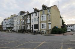
Mitcham's Corner
Jump to navigation
Jump to search
| Mitcham's Corner | |||
| Location Map ( geo) | |||
 | |||
| The East End of Mitcham's Corner | |||
| |||
| Location | |||
| Cambridge | |||
| County | |||
| Cambridgeshire | |||
| Highway Authority | |||
| Cambridgeshire | |||
| Junction Type | |||
| Gyratory | |||
| Roads Joined | |||
| A1303, A1134, C292 | |||
| Junctions related to the A1303 | |||
| Junctions related to the A1134 | |||
| Junctions related to the C292 (Cambridgeshire) | |||
Mitcham's Corner is gyratory system in Cambridge. The junction is named after Charles Mitcham, who owned a draper’s shop on the corner of Chesterton Road and Victoria Avenue from the early-to-mid 20th century. In 1967, the layout of the roads was altered to allow traffic to flow as a gyratory system - which, along with the surrounding shops and houses is known as Mitcham's Corner.
The link below to the development framework, published in January 2017, contains a more extensive history of the junction featuring photographs and other material of historical interest.
Routes
| Route | To | Notes |
| Ring Road: London, Royston, Sandy, Bedford, Newnham, Trumpington | Chesterton Road | |
| Ring Road: Haverhill, Grafton (Parking), Chesterton Abbey, Romsey, Cherry Hinton | Chesterton Road | |
| Newmarket, Ely, Milton, Waterbeach | Milton Road | |
| Huntingdon, Histon, Cottenham, Shire Hall | Victoria Road | |
| Park Street (Parking) | Victoria Avenue |
Links
Cambridge News
Cambridge.gov.uk
- Mitcham's Corner Development Framework (26.01.2017)
