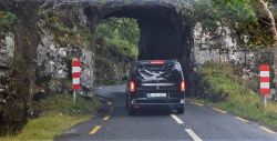
Moll's Gap Tunnel
Jump to navigation
Jump to search
| Moll's Gap Tunnel | |||||
| Location Map ( geo) | |||||
 | |||||
| The tunnel in 2018 | |||||
| |||||
| County | |||||
| Kerry | |||||
| Highway Authority | |||||
| Transport Infrastructure Ireland | |||||
| Additional Information | |||||
| |||||
| On road(s) | |||||
| N71 | |||||
| Crossings related to the N71 | |||||
The Moll's Gap Tunnel is a carved-out rock tunnel in Kerry.
The tunnel is an uncontrolled single lane, and subject to a 4.0m height restriction.
The name of the tunnel is disputed - it appears unnamed on OSI maps, and is north of the Moll's Gap pass. A council notice gave it the name Newfoundland Bay Tunnel, but this was called an error by a local historian[1], who stated that evidence is that when being constructed the tunnel was described simply as being through Cromaglaun and that historically it has been locally known as The Heading.
References
| Moll's Gap Tunnel | ||
|
