Montford Bridge
Jump to navigation
Jump to search
| Montford Bridge | |||||||||
| Location Map ( geo) | |||||||||
 | |||||||||
| Location | |||||||||
| West of Shrewsbury | |||||||||
| County | |||||||||
| Shropshire | |||||||||
| Highway Authority | |||||||||
| Shropshire | |||||||||
| Opening Date | |||||||||
| 1792 | |||||||||
| Cost | |||||||||
| £5,800 | |||||||||
| Additional Information | |||||||||
| |||||||||
| On road(s) | |||||||||
| B4380 | |||||||||
| Crossings related to the B4380 | |||||||||
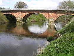
Montford Bridge is a crossing of the River Severn to the west of Shrewsbury. The bridge was designed by Thomas Telford and constructed in 1792. Before Shrewsbury was bypassed for a second time in the 1990s, the A5 formerly travelled over the bridge.
| Montford Bridge | ||
| ||
|


