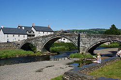
Pont Fawr (Llanwrst)
Jump to navigation
Jump to search
| Pont Fawr | |||||||
| Location Map ( geo) | |||||||
 | |||||||
| Location | |||||||
| Llanwrst | |||||||
| County | |||||||
| Caernarfonshire | |||||||
| Highway Authority | |||||||
| Conwy | |||||||
| Opening Date | |||||||
| 1636 | |||||||
| Additional Information | |||||||
| |||||||
| On road(s) | |||||||
| B5106 | |||||||
This article is about the bridge near Betws-y-coed.
For other bridges with the same name, see Pont Fawr.
For other bridges with the same name, see Pont Fawr.
The Pont Fawr ("big bridge") in Caernarfonshire carries a short branch of the B5106 Conwy to Betws-y-coed road across the River Conwy at Llanwrst. Completed in 1636 (although the central arch had to be reconstructed after it collapsed on opening day), the bridge is today subject to an 18-tonne weight limit. Being too narrow to allow two vehicles to pass, and having a hump-back construction which limits forward visibility, it is equipped with warning lights facing traffic approaching from the south-west side.
| Pont Fawr (Llanwrst) | ||
|