Pont Mwnwgl-y-llyn
| Pont Mwnwgl-y-llyn | |||
| Location Map ( geo) | |||
 | |||
| |||
| Location | |||
| South of Bala | |||
| County | |||
| Merionethshire | |||
| Highway Authority | |||
| Gwynedd | |||
| Opening Date | |||
| 1955 | |||
| On road(s) | |||
| B4391 | |||
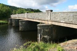
Pont Mwnwgl-y-llyn crosses the River Dee at the outflow from Llyn Tegid (Bala Lake). It is a 5 span concrete bridge dating from 1955 when a major scheme was completed on the Rivers Dee and Clwyd to both control water levels and manage the water that was abstracted for the towns and villages along its length. Each of the spans is a simple concrete slab spanning between substantial stone clad piers, with a stone parapet rising above. The road is a wide S2 with pavements on both sides.
However, the predecessor to this bridge still survives to the south, no longer in use by traffic, nor indeed spanning water, it nevertheless remains, carrying the pedestrian footway to the entrance to the Bala Lake Railway just across the B4403. It is a 3 span stone arch bridge, partially hidden in trees and undergrowth now that it no longer crosses a river. Thought to date from the late 18th century, the bridge seems to crest over the northern arch, with a wobbly parapet line making it difficult to get a true idea of the shape of the bridge.
Junction
The B4391 used to meet the B4403 immediately to the south of the old bridge, however with the new bridge came a realigned road and a new junction, meaning that the two routes now meet a little to the east of the old junction, with the B4391 sweeping round a wide bend.
| Pont Mwnwgl-y-llyn | ||||
| ||||
| ||||
|


