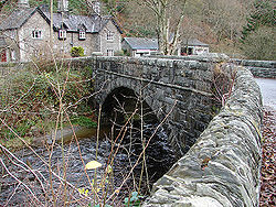
Pont Rhyd-y-groes
Jump to navigation
Jump to search
| Pont Rhyd-y-groes | |||
| Location Map ( geo) | |||
 | |||
| |||
| From: | Pontrhydfendigaid | ||
| To: | Cwmystwyth | ||
| Location | |||
| Pont Rhyd-y-groes | |||
| County | |||
| Cardiganshire | |||
| Highway Authority | |||
| Ceredigion | |||
| On road(s) | |||
| B4343 | |||
This single stone arch across the River Ystwyth is the highest crossing point of a classified road on the river, and indeed there is only one highway bridge across the river closer to its source, and that on the minor road from Cwmystwyth over the hills to the Elan Valley.
Pont Rhyd-y-groes carries the B4343 across the river in the heart of the small village which has taken its name from the bridge. Whilst the bridges date has not yet been ascertained, the style suggests late 19th or early 20th century, although it surely stands on a historic bridge site.
| Pont Rhyd-y-groes | ||||||
|