Star.pngStar.pngStar grey.pngStar grey.pngStar grey.png

Preston Park South Junction

From Roader's Digest: The SABRE Wiki
Jump to navigation Jump to search
Preston Park South Junction
Location Map ( geo)
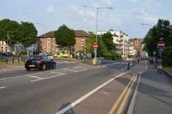
Preston Rd - Geograph - 4687733.jpg
Looking south along the A23
Cameraicon.png No pictures uploaded (Upload?)
Location
Preston, Brighton
County
Sussex
Highway Authority
Brighton and Hove
Junction Type
T Junction
Roads Joined
A23

Preston Park South Junction is the north end of the Gyratory system that stretches between Preston Park and Preston Circus. It was originally a simple T-junction, however it became a roundabout in the 1930s, and shortly after the one way system was introduced it became a kinda of T junction where northbound heading right giveway to traffic southbound turning left.

Routes

Route To Notes

A23

London, Gatwick, (A27) Preston Road

A23

Preston Road (In Only)

A23

Stanford Avenue (Out Only)


Preston Park South Junction
Junctions on the M23 and A23
A23 LondonKennington Oval • Streatham One-Way System • Thornton Heath Pond • Lombard Roundabout • Fiveways Corner • Purley Cross • Brighton Road Roundabout • Hooley
non primary A23Hooley • Lombard Roundabout • The Stations Roundabout • Belfry Roundabout • Longbridge Roundabout • Airport Way Roundabout West • Beehive Ring Road Junction • Gatwick Road Roundabout • Lowfield Heath Roundabout • Fleming Way Roundabout • Manor Royal Junction • Tushmore Gyratory • Ifield Roundabout • Ewhurst Roundabout • Gossops Green Junction • Cheals Roundabout • Southgate Roundabout • Pease Pottage Interchange
M23Unbuilt: 1 Tooting Bec/Streatham •  2 Streatham Vale • 3 Mitcham • 4 Beddington • 5 Wallington • 6 Woodmansterne   Built: 7 Hooley • 8 Merstham • 9 Gatwick • 10 Crawley • 10A Balcombe Road • 11 Pease Pottage
Airport WayAirport Way Roundabout West • 9a Airport Way Roundabout East • 9 Gatwick Interchange
A23 Sussex11 Pease Pottage • Handcross • Slaugham • Warninglid • Bolney Park Farm • Bolney • Hickstead • Sayers Common • Albourne Junctions • Hurstpierpoint • Newtimber • Quarry Junction • Dale Hill • Pyecombe • Patcham • Mill Road Roundabout
A23 BrightonMill Road Roundabout • Carden Avenue Roundabout • Crown and Anchor Junction • Preston Park South Junction • Beaconsfield Crossroads • Preston Circus • Ditchling Road Crossroad • Open Market • St Peters Church • Richmond Parade • North Road • Pavilion Parade • Old Steine • Grand Junction (Aquarium Junction)
Junctions on A roads in Brighton and Hove
A23 (In Brighton)Mill Road Roundabout • Carden Avenue Roundabout • Crown and Anchor Junction • Preston Park South Junction • Beaconsfield Crossroads • Preston Circus • Ditchling Road Crossroad • Open Market • St Peters Church • Richmond Parade • North Road • Pavilion Parade • Old Steine • Grand Junction (Aquarium Junction)
A27 (In Brighton)Coldean Interchange • Hollingbury Interchange • Patcham Interchange • Devils Dyke Interchange • Hangleton Interchange
A259 (In Brighton)[[]] • [[]] • [[]] • [[]] • [[]] • [[]] • [[]] • [[]]
A270Coldean Interchange • Coldean Lane Junction • Moulsecoomb Way Junction • Bevendean Junction • Vogue Gyratory • St Peters Church • Preston Circus • Old Shoreham Road Junction • BHASVIC Crossroads • The Drive Junction • Nevill Crossroads • Hangleton Road Crossroads • Benfield Valley Junction • Southern Cross • Windmill Parade • Kingston Lane Junction • Holmbush Interchange
A293[[]] • [[]] • [[]] • [[]] • [[]] • [[]] • [[]] • [[]]
A2010BHASVIC Crossroads • Seven Dials • Surrey Street Gyratory • Clock Tower • West Street Junction
A2023[[]] • [[]] • [[]] • [[]] • [[]] • [[]] • [[]] • [[]]
A2038[[]] • [[]] • [[]] • [[]] • [[]] • [[]] • [[]] • [[]]


SABRE - The Society for All British and Irish Road Enthusiasts
Discuss - Digest - Discover - Help