Star.pngStar grey.pngStar grey.pngStar grey.pngStar grey.png

R232

From Roader's Digest: The SABRE Wiki
Jump to navigation Jump to search
R232
Location Map ( geo)
Cameraicon.png View gallery (6)
From:  Laghy (G942741)
To:  Pettigo Bridge (border) (H110668)
Distance:  20.9 km (13 miles)
Meets:  N15, R234, R233, A35
Former Number(s):  T35
Highway Authorities

Donegal County

Traditional Counties

Donegal

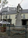
Entering Pettigo along Main Street, the R232

The R232 in County Donegal runs from the N15 at Laghy to the Northern Ireland border and an end-on junction with the A35 in Pettigo.


R232
Roads
Places
Related Pictures
View gallery (6)
1922 Memorial, Pettigo - Geograph - 2072449.jpgRoad at Aghafoy - Geograph - 449688.jpgRoad at Aghafoy - Geograph - 449690.jpgRoad at Camtessy - Geograph - 699930.jpgEntering Main Street, Pettigo, on the R232 - Geograph - 3217555.jpg
Other nearby roads
Donegal
EuroVelo 1 • N15 • N56 • R267 • R925 • T18 • T35 • T72 • Wild Atlantic Way
Pettigo
R200-R299
R200 • R201 • R202 • R203 • R204 • R205 • R206 • R207 • R208 • R209 • R210 • R211 • R212 • R213 • R214 • R215 • R216 • R217 • R218 • R219
R220 • R221 • R222 • R223 • R224 • R225 • R226 • R227 • R228 • R229 • R230 • R231 • R232 • R233 • R234 • R235 • R236 • R237 • R238 • R239
R240 • R241 • R242 • R243 • R244 • R245 • R246 • R247 • R248 • R249 • R250 • R251 • R252 • R253 • R254 • R255 • R256 • R257 • R258 • R259
R260 • R261 • R262 • R263 • R264 • R265 • R266 • R267 • R268 • R269 • R270 • R271 • R272 • R273 • R274 • R275 • R276 • R277 • R278 • R279
R280 • R281 • R282 • R283 • R284 • R285 • R286 • R287 • R288 • R289 • R290 • R291 • R292 • R293 • R294 • R295 • R296 • R297 • R298 • R299
Earlier incarnations : R230

SABRE - The Society for All British and Irish Road Enthusiasts
Discuss - Digest - Discover - Help