Star.pngStar.pngStar grey.pngStar grey.pngStar grey.png

Rayleigh Weir Interchange

From Roader's Digest: The SABRE Wiki
Jump to navigation Jump to search
Rayleigh Weir
Location Map ( geo)
Southend Arterial Road - Geograph - 2138337.jpg
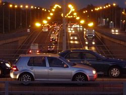
Traffic on the Southend Arterial Road at night, viewed from the Rayleigh Weir roundabout
Cameraicon.png View gallery (4)
Location
near Rayleigh
County
Essex
Highway Authority
Essex
Junction Type
Roundabout Interchange
Roads Joined
A127 Southend Arterial Road, A129

Rayleigh Weir is a grade separated roundabout interchange on the Southend Arterial Road in Essex.

It was named after the village of Weir which was subsumed into the larger urban area of Rayleigh, and the Weir pub on the roundabout.


Aerial view of the roundabout in 1987 prior to grade separation

Opened as a ca crossroads in 1925, the junction was upgraded to a roundabout in 1967 at a cost of £98,000 (source: Hansard 26 January 1967 ), before being grade separated the A127 passing underneath in early 1992, work beginning on 4th December 1989.

Routes

Route To Notes

A127

London, Basildon, Chelmsford (A130)

A127

Southend, Airport, Station, Brook Road Ind. Estate

A129

Rayleigh 1/2

A129

Hadleigh 2, Stadium Trading Est., Little Haven, Thundersley


Links

Other links


Rayleigh Weir Interchange
Related Pictures
View gallery (4)
Heritage Plaque - Geograph - 2185415.jpgHeritage Plaque on the Rayleigh Weir Public House - Geograph - 2185420.jpgSouthend Arterial Road - Geograph - 2138337.jpgAerial view of south-west of the Rayleigh Weir - Geograph - 1665867.jpg
Junctions on the A12, A102 and A127
A102Sun in the Sands • Woolwich Road • Blackwall Lane • South Bromley
A12South Bromley • Bow • Hackney Wick • Lea • Green Man • Redbridge • Gants Hill • Little Heath • Moby Dick • Gallows Corner • 11 Brook Street • 12 Marylands • 13 Trueloves • 14 Furze Hill • 15 Webbs Farm • 16 Howe Green • 17 Stock Road • 18 Sandon • 19 Boreham • 20A Hatfield Peverel South • 20B Hatfield Peverel North • 21 Lynfield Motors • 22 Colemans • 23 Kelvedon South • 24 Kelvedon North • 25 Marks Tey • 26 Eight Ash Green • 27 Spring Lane • 28 Severalls • 29 Ardleigh Crown • 30 Stratford St Mary • Hughes Corner • 31 Four Sisters • 32A Capel St Mary South • 32B Bentley Longwood • 33 Copdock • Barrack Corner • A14 (56) Wherstead • A14 (57) Nacton • A14 (58) Seven Hills • Foxhall Roundabout • Station Square • Gordon Road Roundabout • St Peters Street Roundabout • Jubilee Way Roundabout • Tesco Roundabout • Rackhams Corner • Station Road Roundabout • Links Road Roundabout • Middleton Road Roundabout • Victoria Road Roundabout • Beccles Road Junction • Harfreys Roundabout • Pasteur Road Roundabout • Vauxhall Roundabout
A127Gallows Corner • Cranham • Warley • Halfway House • Dunton • Fortune of War • Upper Mayne • Nevendon • Fairglen • Rayleigh Weir • Kent Elms • Tesco Roundabout • Bell Junction • Cuckoo Corner • Victoria Circus


SABRE - The Society for All British and Irish Road Enthusiasts
Discuss - Digest - Discover - Help