Star.pngStar grey.pngStar grey.pngStar grey.pngStar grey.png

Reedham Ferry

From Roader's Digest: The SABRE Wiki
Jump to navigation Jump to search
Reedham Chain Ferry
Location Map ( geo)
Under way with the Reedham Chain Ferry, Norfolk - Geograph - 498127.jpg
Cameraicon.png View gallery (8)
County
Norfolk
Highway Authority
Norfolk

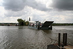
Reedham Ferry is a chain ferry crossing between Great Yarmouth and Norwich. It is the only crossing of any type between these points.


Videos

Reedham Ferry

This little chain ferry is the only way to cross the River Yare between Norwich and Yarmouth, it's a 20 mile trip to get from one side to the other here without the ferry.

Watch video > >


Reedham Ferry
Related Pictures
View gallery (8)
IMG 1518.JPGIMG 1519.JPGIMG 1525.JPGCurrent sign at Reedham Ferry.JPGOld B1140 sign at Reedham Ferry.JPG
Crossings of the River Yare, Waveney and tributaries
River YareLow Street Bridge • Bawburgh Bypass Bridge • Earlham Bridge • Cringleford Bypass Bridge • Harford Bridge • Trowse Newton Bypass Bridge • Postwick Viaduct • Reedham Ferry • Breydon Bridge • Haven Bridge • Herring Bridge
River WaveneyRedgrave Common Bridge • Stuston Bridge • Scole Eastern Bypass Bridge • Scole Southern Bypass Bridge • Shotford Bridge • Homersfield Bridge • Bungay Bypass Bridge 2 • Bungay Bypass Bridge 1 • Beccles New Bridge • St Olaves Bridge
River BureSaxthorpe Bridge • Aylsham Bypass Bridge • Coltishall Bridge • Wroxham Bridge • Acle Bridge • Bure Bridge


SABRE - The Society for All British and Irish Road Enthusiasts
Discuss - Digest - Discover - Help