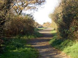
Road to Nowhere
| Road to Nowhere | |||
| Location Map ( geo) | |||
 | |||
| Road to Nowhere in 2016 | |||
| |||
| Road to Nowhere | |||
| From: | Rochford Way (ST699814) | ||
| To: | Yate Common (ST698819) | ||
| Distance: | 0.4 km (0.2 miles) | ||
| Highway Authorities | |||
| Traditional Counties | |||
Yate's Road to Nowhere is a 1974 rural dual carriageway, which was meant to form a relief road around the centre of Yate.
It is about 400m long and runs from a roundabout with Rochford Way, across Yate Common, before coming to an end at the railway line. The absence of a bridge being the reason why the road was not open. It is said that the road was not completed as the cost of the bridge had increased, making the route unaffordable.
The road is accessible to the public from the common, but is also available from South Gloucestershire Council for hire to allow filming to take place. Additional services such as white lining and vegetation clearance are also available[1].
Videos
Tom Scott - Amazing Places - The Never-Used Road where the BBC Crash their Cars
There are lots of disused and never-used roads and bridges in the world. But the Road to Nowhere in Yate, in south-west England, does still sometimes have traffic driving on it. And crashing on it.
References
| Road to Nowhere | ||
| ||
|


