SABRE Maps/Tracing
As well as viewing maps, SABRE Maps provides route traces of most British and Irish roads. These come from contemporary OpenStreetMap mapping, but only for current roads. For historical or defunct roads, we need to roll up our sleeves and create them ourselves. This where the ability to trace an existing map comes in.
Please note the trace functionality is fairly new, and further usability enhancements are planned.
It should also be noted that as tracing from OpenStreetMap is a derivative of works from OpenStreetMap, then all traces with OSM components must be released in accordance with OpenStreetMap copyright requirements. This is the case even if you only use the OSM layer for testing and checking purposes.
Overview
To start a trace, click on the "Trace" button, to the right of the group of buttons at the top of the map. This changes the text to "Trace OFF" and provides a number of toolbar options. We'll cover these in a minute.
Clicking on the Trace OFF link disables tracing and changes the link to Trace ON. Anything you have currently traced is still viewable and will not be lost unless you navigate to another part of the website. Click the link again to turn tracing back on - the "ON" and "OFF" acts as a reminder so you know whether you're actively tracing at the moment.
Creating traces
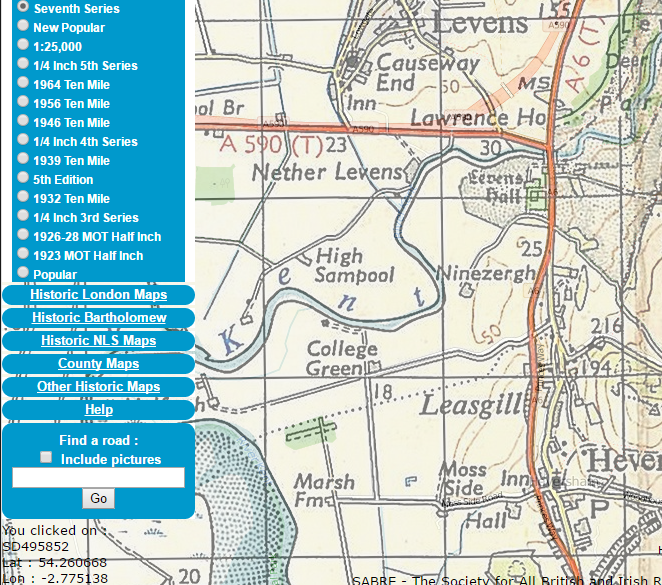
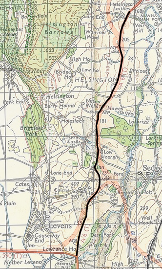
Let's have a look at how you can make a trace. For the example here, we're viewing the "Historic OS Maps" / "Seventh Series" coverage, with the "Create Overlay" feature turned on. This allows us to compare historic and modern mapping side-by-side. We're going to be tracing the former route of the A6 between Levens and Kendal, that today is buried under modern upgrades of the A590 and A591.
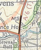
- 1. To begin tracing, simply click on a point on the map. Because you have only clicked on one point, nothing may appear to happen at this point, though will see a confirmation that you have clicked somewhere in the map.
- 2. Click on a second point somewhere else on the map, and a line will be drawn between the two points.
- 3. The more points you click on, the longer the trace becomes. If you follow the line of a road on a map, clicking at each point there's a bend or change in direction, you can build up a complete trace. You can still drag the map around to view different parts, switch to different zoom levels, and even switch to another map (provided the map is in the same group as the one you are currently viewing).
Tips
Some maps are more accurate than others. The best is the modern OpenStreetMap layer, which has been extensively peer reviewed using modern GPS technologies to give a geographically accurate map. The 1:25,000 and Six Inch Ordnance Survey maps also have a detailed scale, that allows a close and accurate trace to be drawn. Maps produced before 1936 pre-date the Retriangulation of Great Britain and are not as reliable as newer maps.
Don't forget that you can overlay the modern OpenStreetMap mapping on top of an historical map, using the former for basic route information and the latter for pinpoint accuracy. However, be careful as numerous single carriageway roads that may superficially appear to have identical routes have had many kinks and bends straightened out in the past 50 years, so a discrepancy in the two maps might be intentional.
Working with the toolbar
The toolbar provides a number of useful options to help work with traces.
Undo
The undo button removes the last clicked on point and back-pedals the trace. Clicking the button a second time removes the next subsequent point after that, and so on; repeatedly clicking "Undo" will ultimately remove the entire trace. This option is useful if you make a mistake and need to wind back data; if you happen to have accidentally traced the wrong part of a route, you can undo up until the point you went the wrong way without having to re-input all the points from scratch.
Clear
This button removes the entire trace. Warning - if you have not saved your trace your entire work will be lost, so click with care!
Save
Clicking on this button brings up a dialog box that allows you to save your trace to a file. You can carry on working on the trace later, or export it to the Wiki. You don't need to give the trace a file extension or path name, just a straightforward name such as old_A6 should suffice in our example.
If you have already saved a trace with the same name, the older trace will be overwritten. If you have previously saved the trace in this session, the default name will be the one you previously entered. This allows you to save your work at regular intervals without losing it.
Note : The trace is saved as standard OpenStreetMap XML, so it is possible to import it into external map applications that recognise it, such as Potlatch.
Load
This button bring up a list of traces you have previously saved. If you click on one of them, it will be loaded into the map. You can then continue tracing from the last point that was loaded in. This means you can save your work, come back to it another day, and pick up where you left off.
If you decide you don't want to load a trace, click on the "Close" button to dismiss the dialog. This has an additional feature that it means you can use the "load" button simply to list what traces you have previously created, if you can't remember the name of one.
Reusing traces in the Wiki
You can reuse traces you create in the Wiki. The Routebox template (see Help:Routeboxes#SABRE Maps extract) and Mapbox template allows you to specify the name of a trace file. For a trace you have created and saved using the steps above (ie: you can see it when you click on the "load" button), this must be of the format user/<your username>/<your trace name>.osm. You can specify multiple traces, separated by semicolon (;) character.
Some examples of pages that use user-created traces are:
- A14 (Royston - Alconbury) -
trace=user/Ritchie333/old_A14.osm- the user trace is the entire (defunct) route. - A38 -
trace=A3/A38.osm;user/Jeni/A38old.osm- the map displays the modern route, and the downgraded section through Somerset and Devon. - T10 -
trace=user/Ritchie333/T15a.osm;user/Ritchie333/T15b.osm;user/Ritchie333/T15c.osm- the map combines a number of disjoint traces that straddle the border between Northern Ireland and the Republic.
Links
