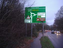
Scilly Isles Junction
| Scilly Isles | |||
| Location Map ( geo) | |||
 | |||
| The approach to the 'Scilly Isles' from Hampton Court | |||
| |||
| Location | |||
| Esher | |||
| County | |||
| Surrey | |||
| Highway Authority | |||
| Surrey | |||
| Junction Type | |||
| Modified Roundabout | |||
| Roads Joined | |||
| A307, A309 | |||
| Junctions related to the A307 | |||
| Junctions related to the A309 | |||
Scilly Isles is the southwestern terminus of the Kingston bypass (formerly A3). Today it forms the junction between the A307 and A309. Its design merges the A307 and A309 traffic from the north and west so that they form one entry and one exit onto the old A3 route.
History
There was originally just a minor junction with a side road leading to Thames Ditton. The opening of the Kingston Bypass in 1927 transformed it into Siamese roundabout that exists today. It is believed the A307 to Hampton Court was built around the same time.
Big changes to the junction were to occur in the 1960s when the Esher Bypass was being planned. Two routes for the bypass were studied in detail. One route was to follow the River Mole and would have been a westward continuation of the Kingston Bypass from the Scilly Isles. The other was the Commons Route which runs to the south of Esher. Either route would have had a big impact on the Scilly Isles as we will discover.
River Mole Route
As mentioned, this route would have extended the Kingston Bypass westwards to pass over the Scilly Isles on its way to rejoin the A3 near Cobham via the River Mole. Slip roads would connect the A3 either side of the roundabout. Two alternative layouts were produced with extra flyovers to remove additional traffic from the roundabout. The layout shown on the final plans features just the flyover carrying the A3 over the roundabout.
Alternative designs to remove additional traffic from the roundabout. Neither was pursued.
Commons Route
This route leaves the A3 at Hook Junction and passes south of Esher to rejoin the A3 at Cobham and is what was built. Therefore it goes nowhere near the Scilly Isles. However, this isn't the end of the story. The county council was planning a link road because a bypass to the south of Esher would mean a large amount of traffic would still be travelling through the town. The link road would join the Scilly Isles to the A3 at Esher Common. The Scilly Isles would be considerably enlarged to become a five arm roundabout. An alternative layout shows the link road continuing over the roundabout to merge onto the A307 from Kingston. This was expected to be the link road's main traffic flow but the basic roundabout without the flyovers was accepted as the final design. The link road was never built due to environmental concerns and community opposition. The result is the Scilly Isles remains unchanged since it was first built in 1927.
Routes
| Route | To | Notes |
| Staines, Hampton Court | There is a height restriction of 15'6" just west of the Scilly Isles. | |
| London, Sutton, (A3) | ||
| Esher, Guildford | In brown; Sandown Park | |
| Kingston | There is a height restriction of 13'3" just north of the Scilly Isles. | |
| London, Sutton | now A309 | |
| Esher, Guildford | now A307 | |
| London, Sutton | provisional number for the bypass | |
| Kingston | Former A3 through Kingston until bypass opened | |
| Guildford, (A3) |
| Scilly Isles Junction | |||||||
| |||||||
|


