Silvertown Bypass
| Silvertown Bypass | ||||
| Location Map ( geo) | ||||
| Modern map with overlay of original bypass | ||||
 | ||||
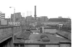
| The viaduct in 1974 | ||||
| ||||
| From: | North Woolwich Road (TQ415802) | |||
| To: | Connaught Road (TQ419802) | |||
| Distance: | 0.5 km (0.3 miles) | |||
| Former Number(s): | A1011 | |||
| Traditional Counties | ||||
| Route outline (key) | ||||
| ||||
The Silvertown Bypass was a concrete viaduct, built as part of a wider scheme of work to relieve congestion in the docklands area around Silvertown. This part of the scheme provided a bridge over the railway line and also over Connaught Road. The A1011 number was given to the bypass.
The viaduct was 580 feet long, and 42 feet wide and was completed in May 1935 and opened on 25th July 1935. The viaduct comprised four concrete reinforced bridge sections, with steps on the south side allow pedestrian access from Oriental Road and Connaught Road. The viaduct was closed in 1991 as part of the redevelopment of the area following the decline of the docks, closure of some of the heavy rail routes, and construction of a more modern road network. The viaduct was demolished in 1995[1]. The Docklands Light Railway now follows the route of the western part of the viaduct, while the Eastern part was redeveloped to provide offices, car parking and hotel accommodation associated with the City Airport.
References
| Silvertown Bypass | ||||
| ||||
|
