Star.pngStar grey.pngStar grey.pngStar grey.pngStar grey.png

St Neots Bridge

From Roader's Digest: The SABRE Wiki
Jump to navigation Jump to search
St Neots Bridge
Location Map ( geo)
St Neots Bridge - Geograph - 97559.jpg
Cameraicon.png No pictures uploaded (Upload?)
Location
St Neots
County
Huntingdonshire
Highway Authority
Cambridgeshire
On road(s)
B1428

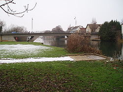
St Neots Bridge crosses the River Great Ouse on the B1428 in St Neots . This is the original major road through St Neots, now replaced with the bypass.


St Neots Bridge
Crossings of the River Great Ouse
Syresham Bypass • Brackley Bypass 2 • Brackley Bypass 1 • Bourton (Buckingham) Bridge  • Stony Stratford Bypass • M1 Viaduct, Newport Pagnell • North West Bridge • Olney Bridge • Turvey Bridge • Paula Radcliffe Way Bridge 2 • Paula Radcliffe Way Bridge 1 • Bromham Bypass Bridge • County Bridge (Bedford) • Town Bridge (Bedford) • Longholme Bridge • Bedford Bypass Viaduct • Tempsford Bridge • St Neots Bypass Bridge • St Neots Bridge • Mill Lane Bridge • A14 Expressway Viaduct • Huntingdon Bypass Bridge • Huntingdon Bridge • St Ives Bridge • St Ives Bypass Bridge • Earith Bridge • Twenty Pence Bridge • Chittering Bridge • Stretham Bridge • Ely High Bridge • Queen Adelaide Bridge • Littleport Bridge • Downham Bridge • Kings Lynn Bypass Bridge


SABRE - The Society for All British and Irish Road Enthusiasts
Discuss - Digest - Discover - Help