Strensham Interchange
| Strensham Interchange | |||
| Location Map ( geo) | |||
 | |||
| |||
| Location | |||
| Strensham | |||
| County | |||
| Worcestershire | |||
| Highway Authority | |||
| National Highways | |||
| Junction Type | |||
| Roundabout Interchange | |||
| Roads Joined | |||
| M5 (J8), M50 | |||
The Strensham Interchange is junction 8 of the M5, linking to the M50. For the M5, it is a standard roundabout interchange, whilst it is a flat roundabout for the M50, of which it is also the terminus. The southbound exit for Strensham services also feeds into this roundabout, merging with the off-slip from the M5.
History

_Ben_Brooksbank_-_Geograph_-_3193189.jpg)
The end of the M50 was originally a trumpet interchange, but when the M5 was widened in the area during the 1980s, the junction was changed into a flat roundabout, eliminating the tightness of the trumpet. Aerial photography shows a field immediately to the east of the roundabout that has the shape of the original trumpet interchange.
There were also plans to redesign the junction in the 1970s to allow for the Strensham - Solihull Motorway.
The first proposals in 1970 had three possible designs. The main flows would be the M5 through route and Solihull to M5 south so these movements were given the smoothest lines. The existing bridge carrying the M5 over the trumpet would be retained in all the designs.


The second proposals in 1972 had two designs. Like the earlier proposals the existing bridge would be retained and the main flows would have high speed connections. The main difference between the two is the preferred layout favours the M5 whereas the alternative has Solihull to M5 south as the main movement.


Routes
| Route | To | Notes |
| The Midlands, Worcester, Birmingham | ||
| The South West, Tewkesbury, Bristol | ||
| South Wales, Ross | ||
| The Midlands (M42), Birmingham (E & C), Evesham | earlier plans for Strensham - Solihull Motorway | |
| The Midlands (M42), Birmingham (E & C), Redditch, Pershore | later plans for Strensham - Solihull Motorway |
Strip Maps
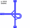
Strensham Interchange as it was upon opening in 1962.
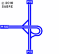
Strensham Interchange as it was upon in 1964.
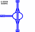
The current layout of the interchange.


Links
legislation.gov.uk
- The M5 Birmingham-Exeter Motorway (Strensham Junction 8) Connecting Roads Scheme 1990 - Scheme to replace the trumpet junction with a roundabout


