The Cock Pitt
| The Cock Pitt | |||
| Location Map ( geo) | |||
| |||
| County | |||
| Derbyshire | |||
| Highway Authority | |||
| Derby | |||
| Junction Type | |||
| Signal Controlled | |||
| Roads Joined | |||
| A6, A601 | |||
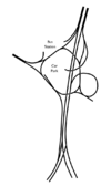
The Cock Pitt is a large junction in Derby, junction 3 of the inner ring road, composed of what could be thought of as a number of separate signal-controlled junctions.
It was built as a large roundabout, which ran under the car park and around what's now part of the bus station. This was converted to the present layout in 2007.
Routes
| Route | To | Notes |
| Loughborough, Pride Park, Station, Park & Ride Car Park | Uses 'becomes primary soon' green patch | |
| Mansfield (A38), Chesterfield (A61), Matlock (A6), Nottingham (A52), Ashbourne (A52) | ||
| Melbourne (A514), Burton (A38), Liversage Street Car Park, Westfield Centre & Basement Car Parks | ||
| Westfield Riverside Car Park | The Cock Pitt | |
| Shopmobility, Assembly Rooms Car Park | Morledge |
The Cock Pitt also has exits to the Morledge, Derby Bus Station, The Cock Pitt multi-story car park and a bus only exit to Siddals Road.
History
In 'Traffic in Derby 1964-2010', the Cock Pitt was planned as a grade separated roundabout with a large car park in the centre (not built until 1998). The plans for grade separation are given away by the flared carriageways which can be seen on aerial photographs.
The Cock Pitt was constructed with Phase II of St Alkmund's Way, and opened to traffic on the 30th July 1972 as a roundabout junction. It was subsequently altered to become a series of smaller, signal controlled junctions. This was done between 2006 and 2009 to allow access to the new bus station and Riverlights development.
The Cock Pitt is named after the road it was built on top of, Cock Pitt Hill.
