Star.pngStar grey.pngStar grey.pngStar grey.pngStar grey.png

Tolworth Junction

From Roader's Digest: The SABRE Wiki
Jump to navigation Jump to search
Tolworth Junction
Location Map ( geo)
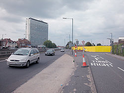
Tolworth junction - Geograph - 134858.jpg
Cameraicon.png View gallery (1)
Location
Tolworth
County
Surrey
Highway Authority
Transport for London
Junction Type
Roundabout Interchange
Roads Joined
A3, A240
Junctions related to the A240

Tolworth Junction is a junction that was created on the Hook Rise section of the Kingston By-pass.

It was built as a staggered crossroads, serving the original through-route: Ewell Road and Kingston Road. With Broadway being built in the 1940s, it became a diamond-shaped flat roundabout. An underpass was later provided.

Routes

Route To Notes

A3

(M25) Portsmouth, Guildford, Esher, Hinchley Wood (A309)

A3

Central London

A240

Reigate, Epsom, Sutton (A232), Ewell, Gatwick Airport (M25), Lorries - Chessington Industrial Estate. Low Bridge 4.6m 15'3"

A240

Kingston


Tolworth Junction
Related Pictures
View gallery (1)
Tolworth junction - Geograph - 134858.jpg
Junctions on the A3
Bank • Monument • Borough • Elephant & Castle • Kennington Oval • Clapham Common • Wandsworth Gyratory • Tibbets Corner • Roehampton Lane • Stag Lane • Robin Hood • Coombe Lane • Shannon Corner • Malden Corner • Tolworth • Hook • Esher Common • Painshill • Wisley • Ockham Park • Send • Burpham • Stoke • Wooden Bridge • University • Hogs Back • Compton • Shackleford • Milford • Thursley • Hazel Grove • Liphook • Griggs Green • Longmoor • Ham Barn Roundabout • Flexcombe • Sheet • Berelands • Weston • QE Country Park • Clanfield • 1 London Road • 2 Hazelton • 3 Hulbert Road • 4 Purbrook Way • 5 Bedhampton Roundabout • Broad Marsh • Spur Road Roundabout • Paulsgrove • Portsbridge Roundabout • Rudmore • Church Street Roundabout • Cambridge Junction


SABRE - The Society for All British and Irish Road Enthusiasts
Discuss - Digest - Discover - Help