Unemployment Relief Road Schemes
Following the Wall Street Crash of the late 1920s, and the subsequent Great Depression, unemployment increased dramatically across the UK. Conversely, car ownership and so road travel continued to grow as more and more people could afford the freedom of owning a car. This was helped enormously by the low prices of cars such as the Austin Seven Morris Minor / Eight and Ford Eight, prices which were driven down as each company tried to outdo the other.
However, despite the rapid increase in road travel, many roads had been little changed since the Turnpike Trusts had been wound up about 50 years earlier. Some important routes had seen massive improvements, other more local routes were little better than potholed, narrow lanes which were incompatible with the modern traffic levels.
Of course, across Europe, other nations were already starting to plan major new road networks and Britain, with its massive Empire still more or less intact, didn't want to lag behind. There was one obvious solution to solve all the problems - a massive road building program would provide modern highways and eliminate a hige chunk of the unemployment 'problem'. The only possible stumbling block was money, but in the event it didn't stop many of the new roads.
New Roads
Whilst many of the roads built were basic upgrades, widenings and full reconstructions along existing alignments, there were many roads which were essentially built from scatch. The most obvious of these is the stretch of the A82 across Rannoch Moor in Scotland. From Bridge of Orchy to the Kingshouse Hotel, a run of 10–12 miles, the road was all brand new. Ok, so the A82 was a pretty exceptional route, but there were others that underwent the same treatment.
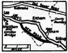
In Somerset, the A370 from East Brent to Weston Super Mare is approximately 8 miles, of which less than a mile existed before 1928. Along with the neighbouring stretch of the A38, which also received several new stretches, the bridges all bear datestones to show the progress of construction.
Both the A38 and the A82 also carry milestones. Those on the A82 appear to have been installed when the new road was built, varying only very slightly from the odomoter in the car. However, those along the A38 between Highbridge and Churchill suggest that they have simply been resited from the original route, as several of the 'miles' are a little short. This occurs where the new road has been straightened such as at East Brent, or at Cross.
These are just a couple of very local snapshots to illustrate the kind of projects undertaken in the late 1920s and on through the 1930s. Trying to compile a complete list would probably see over half the routes described on the Sabre Wiki listed in part at least, so why not check the old maps, for your local roads, or better still go and look at the bridges. Small ones will probably bear a datestone somewhere, more important ones will have a plaque detailing the engineers, contractors, date of opening and the official who opened the bridge.
| Unemployment Relief Road Schemes | ||
|