Waterdale Interchange
| Waterdale | |||
| Location Map ( geo) | |||
 | |||
| The Mr Floppy sign in the rain. | |||
| |||
| Location | |||
| Bricket Wood | |||
| County | |||
| Hertfordshire | |||
| Highway Authority | |||
| National Highways | |||
| Junction Type | |||
| Parclo | |||
| Roads Joined | |||
| M1, A405 | |||
| Junctions related to the A405 | |||
Waterdale Interchange is junction 6 of the M1. It is the home of the original 'Mr Floppy' sign. It connects to the A405 North Orbital Road, which is trunk to the northeast of the junction, forming the link between the M1 to/from London and the M25.
The basic form of the interchange has gone unchanged since it opening in 1959, however, at that time the M1 through these parts was dual 2 lane (D2M) and remained this way until the junctions 5 to 8 were widened in the early 1980s to D3M. Originally, both carriageways of the motorway crossed the A405 using the western bridge. The motorway was widened by building a new bridge just to the east which carries the southbound carriageway, with the western bridge now carrying the widened northbound carriageway.
The Google Streetview images show the over-wide northbound bridge from above and below and the new bridge from the east.
The M1 through this interchange was the last section of low pressure sodium Catenary Street Lighting in the country, however this was removed in 2021.
Routes
| Route | To | Notes |
| The NORTH, Luton & Airport | ||
| C. London, Brent Cross, Harrow, Watford | ||
| (M25), St Albans | ||
| North Watford | ||
| Bricket Wood | Old Watford Road | |
| Bricket Wood | Mount Pleasant Lane. 7.5 Ton weight limit except for loading, 14'6" height limit in 1 mile |
Strip Maps
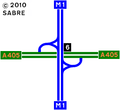
The current layout of the interchange.

Links