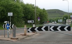
Whistlefield Roundabout
| Whistlefield Roundabout | |||
| Location Map ( geo) | |||
 | |||
| |||
| Location | |||
| Garelochhead | |||
| County | |||
| Dunbartonshire | |||
| Highway Authority | |||
| Argyll and Bute | |||
| Junction Type | |||
| Roundabout | |||
| Roads Joined | |||
| A814, B872 | |||
| Junctions related to the B872 | |||
The Whistlefield Roundabout lies at the northern end of the Garelochhead Bypass on the A814. The bypass was built as part of the military roads providing access to Faslane and Coulport Naval bases. Heading west from here, an unclassified military road (open to the public) takes traffic across the hills to Coulport, while to the east the bypass links up with the A817. As with the other roundabouts on the bypass, a roadway cuts through the middle of the island to allow larger vehicles to pass between the bypass and Coulport Roads without having to negotiate the roundabout itself.
The old A814 through Garelochhead is now the B872, running south from here to the Faslane Roundabout at the other end of the bypass, while to the north the A814 continues to Arrochar. However, the route north along Loch Long is of extremely poor quality compared to the rest of the A814 route. It is narrow and twisty, indeed little better than the notorious stretch of A82 along Loch Lomondside, a far cry from its start on the Clydeside Expressway.
Routes
| Route | To | Notes |
| Arrochar | Signed as "Clyde Sea Lochs Trail (north)" on approach from Coulport | |
| Helensburgh, CSB Faslane | "HMNB Clyde 2" within red border. Signed as "Clyde Sea Lochs Trail (south)" on approaches from Coulport and Arrochar | |
| Garelochhead, Kilcreggan (B833) | Only signed as B872 on roundabout: also signed as A814 on approaches and roundabout. Signed as Clyde Sea Lochs Trail on roundabout | |
| RNAD Coulport 6 | red border sign |
| Whistlefield Roundabout | ||
| ||

