Wightwick Bridge
Jump to navigation
Jump to search
| Wightwick Bridge | |||||
| Location Map ( geo) | |||||
 | |||||
| Location | |||||
| Wightwick, Wolverhampton | |||||
| County | |||||
| Staffordshire | |||||
| Highway Authority | |||||
| Wolverhampton | |||||
| Additional Information | |||||
| |||||
| On road(s) | |||||
| U114 | |||||
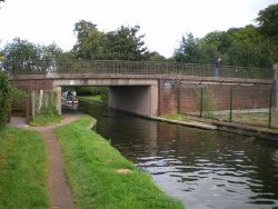
Wightwick Bridge on the west side of Wolverhampton carries the U114 Windmill Lane across the Staffordshire and Worcestershire Canal.
The original narrow arch bridge was provided across the canal in this location and opened in 1771. The present bridge is a twentieth century creation, and is a girder bridge with footways on either side separated by pedestrian barriers.
| Wightwick Bridge | ||
|


