A19
Moderator: Site Management Team
-
Chris Bertram

- Member
- Posts: 15836
- Joined: Tue Nov 13, 2001 12:30
- Location: Birmingham, England
Re: A19
Ditto. But then again I'm old enough to remember when A19 actually ran through Stockton, Billingham, Castle Eden, Easington village, Cold Hesledon, New Seaham, Ryhope et al. And along Fawcett Street in the centre of Sunderland.
Did you know there's more to SABRE than just the Forums?
Add your roads knowledge to the SABRE Wiki today!
Have you browsed SABRE Maps recently? Try getting involved!

Re: A19
Me too, I recall driving along it while they were building the bypasses, at that time my usual route heading north to Scotland was over the Newport Bridge to Billingham and Norton before driving the Wolviston road to the A689 then west to the A1(M). The current A19 from Crathorne to Billingham only opened in 1975, before that the A19 went along Stockton High Street.Chris Bertram wrote: ↑Fri Feb 16, 2024 21:48 Ditto. But then again I'm old enough to remember when A19 actually ran through Stockton, Billingham, Castle Eden, Easington village, Cold Hesledon, New Seaham, Ryhope et al. And along Fawcett Street in the centre of Sunderland.
South of Crathorne the A19/A168 went through the market place at Thirsk crossing the bridge at Asenby here.
https://www.google.com/maps/@54.1779386 ... &entry=ttu
I cant quite remember when the old flat junction at Dishforth was replaced as before that most traffic, including the coaches, followed the A19 to York and then took the A64 to the A1 at Bramham.
I know I have posted this link before but its worth a look.
https://www.gazettelive.co.uk/news/tees ... r-26123105
They demolished half the town centre including the old Royal Exchange to build it.

Re: A19
The first GSJ at Dishforth was about 1988-9 if I remember correctly. At that time the expectation was that the A1 would later be upgraded to D3 AP with marginal strips. The layout only lasted for about 7 years because it was changed when the A1 was upgraded to D3M plus local access road, opened 1995.
I have never seen an OS map, at any scale, showing the first GSJ. In response to a query from me, Bryn posted a clip from a 1994 A-Z map. See the three consecutive posts (me, Bryn, me) beginning at this link:
viewtopic.php?p=1299393#p1299393

Re: A19
https://i.ebayimg.com/images/g/SyoAAOSw ... -l1600.jpg
Big and complex.
-
GillsPeter
- Member
- Posts: 31
- Joined: Sat Apr 01, 2023 18:50
Re: A19
There's a GSJ for sale on eBay? I hate to think the postage and packaging on that!Truvelo wrote: ↑Sun Feb 18, 2024 19:07 There's a 1989 Landranger showing the first GSJ for sale on ebay. Thankfully the seller took a photo of the right section of the map.
https://i.ebayimg.com/images/g/SyoAAOSw ... -l1600.jpg
Re: A19
I can remember the A19 going through the eastern suburbs of Stockton until 1977, when the new by pass was built and the Tees Bridge opened. Also until 1981, remember the A66 trudging through the south of the town and the western suburbs of Middlesbrough until a nice D2 by pass was built to relieve both towns.Chris Bertram wrote: ↑Fri Feb 16, 2024 21:48Ditto. But then again I'm old enough to remember when A19 actually ran through Stockton, Billingham, Castle Eden, Easington village, Cold Hesledon, New Seaham, Ryhope et al. And along Fawcett Street in the centre of Sunderland.
-
Chris Bertram
- Member
- Posts: 15836
- Joined: Tue Nov 13, 2001 12:30
- Location: Birmingham, England
Re: A19
A19 always went through the centre of Stockton, but through traffic was directed along A1027 which is the road that passes through the *western* suburbs. It's still there, albeit not as important now. The route of the old A19 is now A135 from Yarm to Stockton and A139 from Stockton to BilliinghamGlenn A wrote: ↑Sun Feb 18, 2024 19:56I can remember the A19 going through the eastern suburbs of Stockton until 1977, when the new by pass was built and the Tees Bridge opened. Also until 1981, remember the A66 trudging through the south of the town and the western suburbs of Middlesbrough until a nice D2 by pass was built to relieve both towns.Chris Bertram wrote: ↑Fri Feb 16, 2024 21:48Ditto. But then again I'm old enough to remember when A19 actually ran through Stockton, Billingham, Castle Eden, Easington village, Cold Hesledon, New Seaham, Ryhope et al. And along Fawcett Street in the centre of Sunderland.
Did you know there's more to SABRE than just the Forums?
Add your roads knowledge to the SABRE Wiki today!
Have you browsed SABRE Maps recently? Try getting involved!
From the SABRE Wiki: A1027 :
The A1027 forms the Stockton-on-Tees western bypass, a road now less important than when originally built as the A19 now runs to the east of the town.
The road starts at a roundabout in the Preston Farm Industrial Estate. The A135, which has come in from the south along the old A19 now turns east and the A1027 continues north along that line. It is dual past the next roundabout, a GSJ with the A66, then narrows just after crossing the York to Middlesbrough
-
DeptForLameExcuses

- Member
- Posts: 271
- Joined: Fri Jul 08, 2005 13:41
- Location: Bristol, UK
- Contact:
Re: A19
I have found out, some time ago, when all of this section was built. It was not really declared as a strategic through-route, as you could expect, but it was built in a minimal-publicity manner. No Watership Down rabbits having nightmares, or protesters. I don't think that it was built as a national scheme, merely just a local scheme, not a B road, an un-numbered road or something. But a good un-numbered road? A lot of new settlements were being built at the time. The bulldozer-friendly Cramlington. Think East Germany. Milton Keynes with Tyneside accents.
And it was built earlier than you might expect. Although the A1 was diverted around the Tyne Tunnel from the mid-1970s or something, you tell me, the section north of the Tyne Tunnel was built from 1970-72, or earlier than that. Most was built by 1972 or something. I think, from memory, it was built in 1969? It was ahead of its time. And the private-school-educated protesters.
-
Ritchie333

- SABRE Developer
- Posts: 12045
- Joined: Tue May 20, 2003 20:40
- Location: Ashford, Kent
- Contact:
Re: A19
You don't need to rely on memory, we have mapping evidence directly on SABRE. The 1968 one inch shows the A108 (as was) from the Tyne Tunnel to the A1058, the 1970 quarter inch shows it complete to the A191 and under construction to the A189, while the whole road is complete as of the 1972 one inch.DeptForLameExcuses wrote: ↑Sun Mar 24, 2024 17:32 Although the A1 was diverted around the Tyne Tunnel from the mid-1970s or something, you tell me, the section north of the Tyne Tunnel was built from 1970-72, or earlier than that. Most was built by 1972 or something. I think, from memory, it was built in 1969? It was ahead of its time. And the private-school-educated protesters.
Meanwhile, the 1974 route planner shows the road as primary to the A1058, but non-primary beyond this.
SABRE Maps - all the best maps in one place....
-
DeptForLameExcuses
- Member
- Posts: 271
- Joined: Fri Jul 08, 2005 13:41
- Location: Bristol, UK
- Contact:
Re: A19
I know it wasn't the early 1970s, because it was going over the Tyne Bridge, and the Central Newcastle Motorway. I think it was diverted before the 1980s, so I think 1977-78? Maybe 1976, but I think later.

Re: A19
Again, it's in the SABRE Wiki :DeptForLameExcuses wrote: ↑Sun Mar 24, 2024 17:59 Now to guess when the A1 was diverted through the (one-lane) Tyne Tunnel. Why put the A1 through a one-lane tunnel?
I know it wasn't the early 1970s, because it was going over the Tyne Bridge, and the Central Newcastle Motorway. I think it was diverted before the 1980s, so I think 1977-78? Maybe 1976, but I think later.
"History
In 1977, Newcastle upon Tyne and Gateshead had had a de facto eastern bypass for a few years, but the A1 still ran through the centre. Though part of that route had been upgraded with a swish new urban motorway avoiding the city centre, the rest of the motorway plans that would provide a decent bypass for through traffic that still served the city centre had been scuppered. As such, various routes were renumbered so as to give a bypass for A1 traffic via the relatively new Tyne Tunnel. The route took over the A194(M) between Birtley and White Mare Pool, the A184 between White Mare Pool and Testos Roundabout and the A108 between Testos and Seaton Burn. Many other roads were renumbered at this time due to the moving of the zone-boundary.
In 1990, the Newcastle Western bypass opened and A1 traffic was diverted that way, undoing most of the renumberings caused by the move eastwards, though what was the A108 became A19."
https://www.sabre-roads.org.uk/wiki/ind ... yne_Tunnel
From the SABRE Wiki: A1/via Tyne Tunnel :
From 1977 to 1990 the A1 ran around the east of Newcastle upon Tyne, via the Tyne Tunnel (for the current routing in this area see A1/Birtley - Morpeth).
In 1977, Newcastle upon Tyne and Gateshead had had a de facto eastern bypass for a few years, but the A1 still ran through the centre. Though part of that route had been upgraded with a swish new urban motorway avoiding the city centre,
Re: A19
I'm unsure on the date, but it's better having one lane through a tunnel vs one lane through the centre of Low Fell and Gosforth which the A1 also used at the time.DeptForLameExcuses wrote: ↑Sun Mar 24, 2024 17:59 Now to guess when the A1 was diverted through the (one-lane) Tyne Tunnel. Why put the A1 through a one-lane tunnel?
Re: A19
Big and complex.
Re: A19
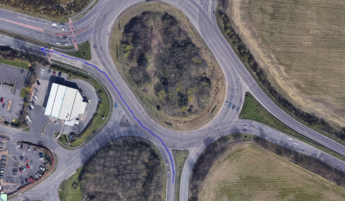
Must admit, one thing that baffles me about Moor Farm is the fact that the A1171 is totally ignored on the roundabout markings and is completely a mismatch of deciding whether that's the way to Cramlington or not the way to Cramlington.
-
JammyDodge

- Member
- Posts: 494
- Joined: Sat Oct 13, 2018 13:17
Re: A19
It would be a pretty dangerous move.
Using general rules of use on a roundabout, I'd be perfectly in my rights to be in the left lane to exit onto the A1171. You'd be crazy to cut across to exit. Unless marked on the road, I would argue that in a right hand lane, you're best off heading straight on (if the exit is two lanes) or turning right.
Sooner or later, if you take the above approach, you are going to have a serious accident.
Re: A19
Re: A19
growing up in Durham, A1 and A59 was the usual route for York... I knew A19 was all dual north of Boro and south of the Tyne, so what I assumed was that the whole lot of that road was dual! so getting driven onto that road south of thirsk for the first time was... interestingGlenn A wrote: ↑Sat Apr 13, 2024 13:41 Then there is the A19 south of Thirsk which is S2 and still goes through York as a non primary route. It's like a completely different road to the section from Thirsk to Seaton Burn, but has a much lower volume of traffic. Easingwold being by passed was a big improvement, though.
its what I imagine the whole route looked like pre the 1960s