Bridge Foot (Belper)
| Bridge Foot | |||||
| Location Map ( geo) | |||||
 | |||||
| The bridge in 2017 | |||||
| |||||
| Location | |||||
| Belper | |||||
| County | |||||
| Derbyshire | |||||
| Highway Authority | |||||
| Derbyshire | |||||
| Opening Date | |||||
| Late C18/Early C19 | |||||
| Additional Information | |||||
| |||||
| On road(s) | |||||
| A517 | |||||
| Crossings related to the A517 | |||||
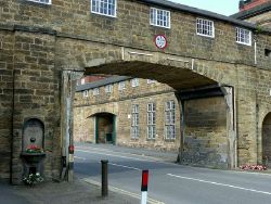
Bridge Foot is a road that forms part of the A517 at the north end of Belper. Above the road is an enclosed arched stone footbridge which links two former textile mills (the North Mill to the now-demolished West Mill).
The bridge was listed at grade 2* in 1966, but by 2020 appeared on English Heritage's Heritage at Risk Register as roof maintenance on the structure is urgently required. The entry also notes historical damage from repeated vehicle impacts which has mainly been alleviated by the introduction of modern signage[1].
The bridge is also interesting as it has ports from where muskets can be fired (the English Heritage link presumes that this is a precaution against Luddite attacks), making this perhaps the most recent fortified bridge built in the country.
The bridge is located just to the south of Belper Bridge.
References
| Bridge Foot (Belper) | ||
|
