The start of the A50
Original post-Warboys sign signaling the beginning of the cross-country route in Warrington. There used to be a similar looking sign signaling the large A57 roundabouts at both sides of the town, however both were removed when the Midland Way fly-over were completed.
Originally uploaded to Coppermine on Jan 17, 2007 by snowdon Pre-Warboys sign on the A50 in Warrington
Pre-Warboys sign on the A50 in (east) Warrington. The indicated turn is no longer the A574, and you can't realy get to Leigh that way ether. (sign now removed)
Originally uploaded to Coppermine on Apr 03, 2005 by Mediaman_12 Warrington Bridge
Warrington Bridge played an important part in the defence of Warrington during the Civil War. In 1648, the remnants of the Duke of Hamilton's army surrendered to Cromwell here.
Kingsway crosses the Mersey
New part time signals - A57/A49 Cockhedge roundabout, Warrington.
These new (halogen) Helios heads are part time, however I've not seen them off yet! The approaches appear to have MOVA loops, however this particular column is holding a Video Detection AGD.
Originally uploaded to Coppermine on Dec 30, 2009 by traffic-light-man July 1963
More M6 was opened and, a speed limit was proposed.
Originally uploaded to Coppermine on Jul 16, 2008 by SteveA30 Looking towards Grappenhall
This would have been a major junction in the pre-motorway era.
The A57 and A50 meet at traffic lights at Paddington, Warrington.
Horsemarket Street, Warrington A view down the former A49, Horsemarket Street in Warrington town centre, Cheshire, England.
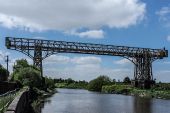
Warrington Transporter Bridge The Warrington Transporter Bridge (or Bank Quay Transporter Bridge) across the River Mersey is a structural steel transporter bridge. The bridge has a span of 200 ft (61 m), is 30 ft (9.1 m) wide, 76 ft (23 m) feet above high water level, with an overall length of 339 ft (103 m) feet. It was constructed in 1915 and fell into disuse in approximately 1964. It was designed by William Henry Hunter and built by Sir William Arrol & Co.
It was the second of two transporter bridges across the Mersey at Warrington. The first was erected in 1905 slightly to the north of the existing bridge, and was described in The Engineer in 1908. A third transporter bridge over the Mersey was the Widnes-Runcorn Transporter Bridge, built in 1905 and dismantled in 1961.
The Warrington Transporter Bridge was constructed to connect the two parts of the large chemical and soap works of Joseph Crosfield and Sons. It was originally designed to carry rail vehicles up to 18 long tons (18 tonnes) in weight, and was converted for road vehicles in 1940. In 1953 it was further modified to carry loads of up to 30 long tons (30 tonnes).
The bridge is recorded in the National Heritage List for England as a designated Grade II listed building, and because of its poor condition it is on the Heritage at Risk Register. The bridge is protected as a Scheduled Ancient Monument.
A local group called 'Friends of Warrington Transporter Bridge' (FoWTB) was formed in April 2015 to act as the independent voice of the bridge. The group is liaising with other interest groups to safeguard the future of the bridge and its industrial heritage status. FoWTB have been featured on the local BBC News programme North West Tonight and have set up a website for the bridge along with Facebook and Twitter pages. In 2016, the bridge was nominated for the Institution of Civil Engineers North West Heritage Award.
Derelict Warrington Transporter Bridge
A sign for Cromwell Avenue where Westbrook Way meets (note the 40mph sign in the background).
Approaching a roundabout on Cromwell Avenue (A574) from Westbrook Way.
Whittle Avenue Roundabout junction sign at end of Westbrook Way. The grimy sign is due soon for replacement, after new area at third exit is built.
Red figure-x bridge over Eastern terminus roundabout of Westbrook Way on A574 Cromwell Ave. 30mph speed limit sign for Cromwell Ave visible. There were originally black panels in the bridge below the railings, but as this picture is more recent, they have been painted over so that the bridge is completely red. The red/black colour scheme is still visible on the other red bridge however, whose pillars are painted black.
The end of the tertiary section of Lingley Green Ave, away from the A5280, about to join the A5281.
Route sign along the A57 for the Warburton Toll bridge and A6144 (via B5159)
Warburton Bridge toll charges (as of Spring 2021)
Penketh area sign, heading Westbound away from Warrington town centre
Route sign Southbound between the two five-way roundabouts on the A5281.
Southbound exit from Thatched Cottage Roundabout on A5281 towards A57 Sankey Way
Northbound on A5281 approaching Thatched Cottage Roundabout, towards Burtonwood Interchange and M62
Northbound on A5281 approaching Thatched Cottage Roundabout. Roundabout sign and left turning lane seen
Roundabout on A5281 for Southern Chapelford (Moran Drive), showing exit sign for Warrington West train station, and 20mph zone (the ENTIRETY of the Chapelford area)
Sign for roundabout Northbound serving Southern Chapelford (Moran Drive). Routes North to Wigan, A49, Gemini, Burtonwood, M62/M6. Warrington West train station sign visible in distance.
Sign approaching A57 junction on A5281. Left for Warrington via Sankey Way A57 and Penketh/Widnes round the corner via A562, the turn for which has the most traffic, yet the right turn is prioritised (causing congestion at peak times). Dual carriageway ahead in blue; routes in green, with white background, shows a sharp shift into a primary route.
Roundabout for Northern Chapelford and Whittle Hall, North exit, showing routes for motorways and Wigan A49.
30mph speed limit drop downhill towards bottom of A5281, before final roundabout.
Final roundabout on A5281 before A57. Sign left for Hood Manor residential area.
Southbound sign for Penketh and Hood Manor approaching final roundabout on A5281
The roundabout where the A5280 TOTSOs onto Lingley Green Ave, taken from the Barrow Hall Lane exit. Currently under construction as of July 2021.
Sankey Green junction sign from A5061. A5061's Western terminus
First junction sign for Sankey Green, approaching Eastbound from Sankey Way (A57), showing road routes.
Second junction sign approaching Sankey Green Eastbound from Sankey Way (A57), showing more specific local destinations. Includes the 'Pink Eye Building' visible in the background, and a speed limit change from 40 to 30mph.
Sankey Green exit for A57 Eastbound (Priestley Street), showing toucan crossing and route sign. A57 is no longer a dual carriageway from this point.
Sankey Green from Sankey Way (A57) Eastbound, showing three-lane entrance to junction, its overhead signals, and recent roadworks (which were resurfacing Lovely Lane, the tertiary first exit).
Route sign for Bridgefoot entering from the A5061 Northbound.
Route sign for Bridgefoot entering from the A5061 Eastbound.
Route sign approaching Bank Quay crossroads at which the A5061 TOTSOs.
Route sign approaching the Bank Quay Crossroads Northbound.
Route sign on the A5061 pointing to the (unsigned) A5196 link road.


_-_Flickr_-_10622905676.jpg)


