Ah thanks, I wasn't aware I'd assumed that the tunnel was the Ferrytoll junction tunnel to Rosyth. It looks like it is probably underneath the M90/sliproads, very little on the ground even hints at this branch ever existing!jnty wrote: ↑Wed Dec 13, 2023 12:39You may be aware of this but the tunnel that was filled did not carry the Rosyth branch. As far as I'm aware, the Rosyth branch runs under the Ferrytoll roundabout in at least two tunnels which are more or less intact, though it's possible the Queensferry Crossing works there obliterated them. As you say though the branch was theoretically active very recently, so it's possible they were required to keep the right of way physically intact.wallmeerkat wrote: ↑Wed Dec 13, 2023 11:58I ended up down a bit of rabbithole looking this one up. I was surprised for example, why the low bridge wasn't removed. There is some discussion here - https://www.railforums.co.uk/threads/ro ... ic.239689/Summers-lad wrote: ↑Wed Dec 13, 2023 10:58
Interestingly, that line isn't shown on any of Sabre's historic maps as far as I've found. (It's on the 1:250k open data.) Maybe it was classed as a military secret?
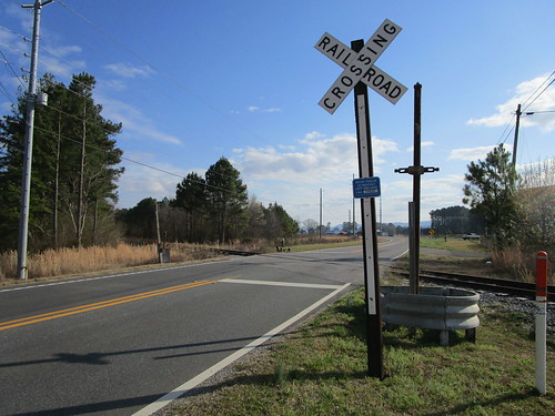
It seems it was active at least in the 80s, with possibly the last picture taken of a train on the line in 2010 https://www.railscot.co.uk/img/29/753/
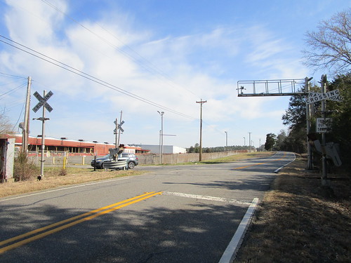
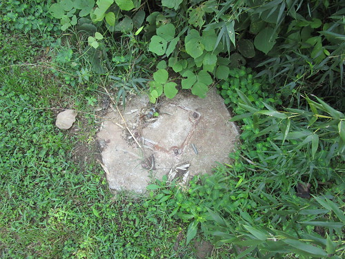
The tunnel under the M90 Ferrytoll was made safe packed with polystyrene boxes - https://www.theforthbridges.org/news-an ... made-safe/ - but interestingly done in such a way as it was reversible, should the line be reopened...
This link shows the old line crossing over the Rosyth branch. I don't think it survived much longer as it appears to have been lost during FRB construction (it was already shown as dismantled on this map.)
https://maps.nls.uk/geo/explore/#zoom=1 ... s=170&b=10
Abandoned Level Crossings
Moderator: Site Management Team
-
wallmeerkat
- Member
- Posts: 1334
- Joined: Fri Apr 20, 2018 16:49
- Location: County Down
Re: Abandoned Level Crossings
-
Ritchie333

- SABRE Developer
- Posts: 11913
- Joined: Tue May 20, 2003 20:40
- Location: Ashford, Kent
- Contact:
Re: Abandoned Level Crossings
I recall driving over the level crossing at Canley some time in the late 1990s. I was going to have lunch with some friends at what is now the Farmhouse pub just north of the station and had to stop for a train. Even back then, the old industrial works had been swept aside for business parks, and there were obviously plans to upgrade the line between Coventry and Birmingham and do away with these sorts of things, so the road leading up and over the level crossing looked like a complete anachronism in stark contrast to everything around it. I could probably describe it as a "dead road driving" as it closed a few years later.
--
SABRE Maps - all the best maps in one place....
SABRE Maps - all the best maps in one place....
-
wallmeerkat
- Member
- Posts: 1334
- Joined: Fri Apr 20, 2018 16:49
- Location: County Down
Re: Abandoned Level Crossings
Nearby Tile Hill also looks stopped off where it was once a level crossing.Ritchie333 wrote: ↑Wed Dec 13, 2023 14:49 I recall driving over the level crossing at Canley some time in the late 1990s. I was going to have lunch with some friends at what is now the Farmhouse pub just north of the station and had to stop for a train. Even back then, the old industrial works had been swept aside for business parks, and there were obviously plans to upgrade the line between Coventry and Birmingham and do away with these sorts of things, so the road leading up and over the level crossing looked like a complete anachronism in stark contrast to everything around it. I could probably describe it as a "dead road driving" as it closed a few years later.
-
Octaviadriver
- Member
- Posts: 1738
- Joined: Fri Dec 17, 2004 20:20
- Location: Powys
Re: Abandoned Level Crossings
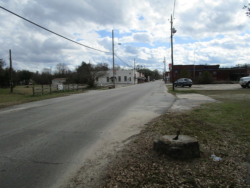
This one is on Burryport Road on the southern edge of Northampton that was part of the line from Northampton to Peterborough. The last date the crossing existed on Streetview was October 2012. It seems odd that there is a short stretch of line intact complete with a siding that still seems to be in use, though the line has been severed, that can be seen from the satellite view. There were a number of level crossings on this line where it ran along the Nene Valley.
https://maps.app.goo.gl/cwqdT7YGHWN5CDYHA
https://maps.app.goo.gl/cwqdT7YGHWN5CDYHA
-
wallmeerkat
- Member
- Posts: 1334
- Joined: Fri Apr 20, 2018 16:49
- Location: County Down
Re: Abandoned Level Crossings
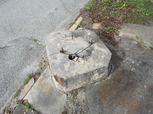
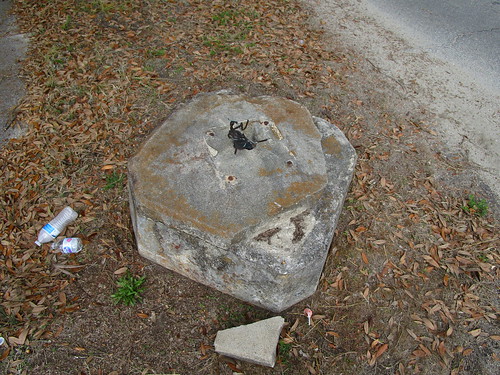
2009 and 2012 GSV seems to show it crossing. What are the zigzags on the rails for?Octaviadriver wrote: ↑Wed Dec 13, 2023 16:57 This one is on Burryport Road on the southern edge of Northampton that was part of the line from Northampton to Peterborough. The last date the crossing existed on Streetview was October 2012. It seems odd that there is a short stretch of line intact complete with a siding that still seems to be in use, though the line has been severed, that can be seen from the satellite view. There were a number of level crossings on this line where it ran along the Nene Valley.
https://maps.app.goo.gl/cwqdT7YGHWN5CDYHA
https://www.google.co.uk/maps/@52.22292 ... ?entry=ttu

Re: Abandoned Level Crossings
It's stainless steel welded on. It usually has two functions - mostly it is to ensure the track circuit registers the presence of the train and it also makes a right racket in the cab. They had it at Manchester Piccadilly when the London trains were loco hauled. They had to run round the coaches, which needed a set of points near the buffers. The loco needed to pull up to the buffers to clear the points but that track would be greasy and not very polished so the welding ensured good contact to show the signalman he could switch the points.wallmeerkat wrote: ↑Thu Dec 14, 2023 10:292009 and 2012 GSV seems to show it crossing. What are the zigzags on the rails for?Octaviadriver wrote: ↑Wed Dec 13, 2023 16:57 This one is on Burryport Road on the southern edge of Northampton that was part of the line from Northampton to Peterborough. The last date the crossing existed on Streetview was October 2012. It seems odd that there is a short stretch of line intact complete with a siding that still seems to be in use, though the line has been severed, that can be seen from the satellite view. There were a number of level crossings on this line where it ran along the Nene Valley.
https://maps.app.goo.gl/cwqdT7YGHWN5CDYHA
https://www.google.co.uk/maps/@52.22292 ... ?entry=ttu
-
freebrickproductions

- Member
- Posts: 196
- Joined: Fri Mar 10, 2023 00:11
- Location: Huntsville, AL
- Contact:
Re: Abandoned Level Crossings
Apologies for the long post, but there's been a good few abandoned lines (and, by extension, crossings) that I've wanted to share for a bit, but couldn't entirely figure out how to get around to doing it. Given how many abandoned crossings around here these days are just the empty ROW with maybe a section of different pavement/tarmac and/or some rails poking out of the road, like this crossing just north of New Market, AL, and this crossing on Oakwood Avenue here in Huntsville, AL, both of which were located on the L&N's Huntsville Branch. Similarly, I'm gonna skip over most abandoned industrial spur crossings like this one in Gadsden, AL, and this one in Decatur, AL, where only the rails in the road mark that trains once crossed there. Similarly, I'm gonna skip over most abandoned crossbuck-only crossings like this one in Sheffield, AL, this one in Birmingham, AL, and these ones in Richland, GA, as many crossings across the US are only protected by them, including many abandoned/out of service ones. While I'll include any photos I've personally taken of the crossings I discuss though, I will also be including street view links to them along with, so that if you want to look at others along the line you can do so.
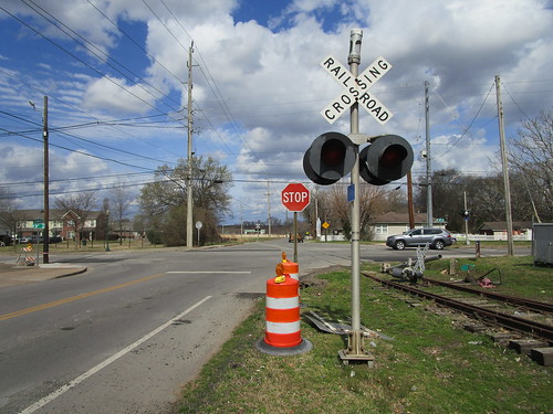
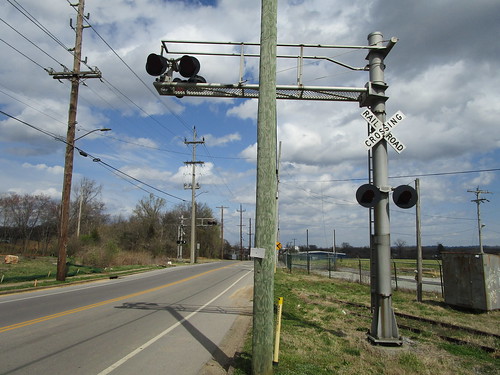
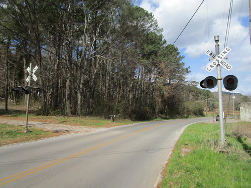
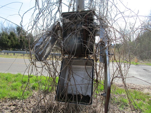
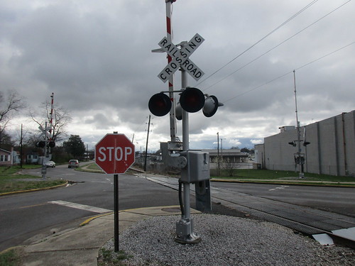
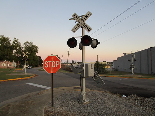
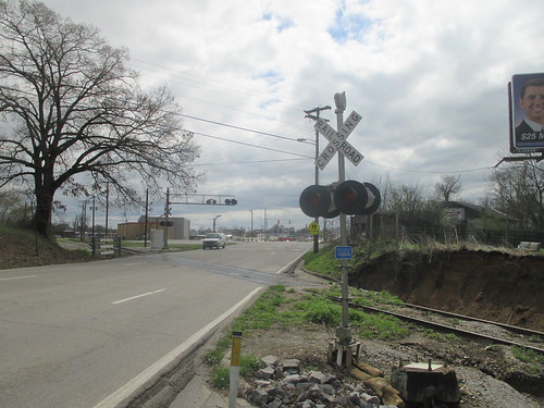
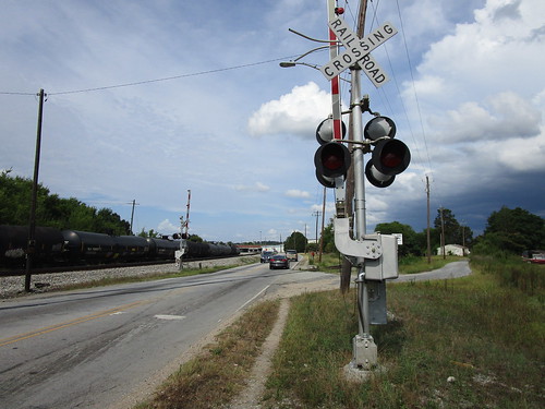
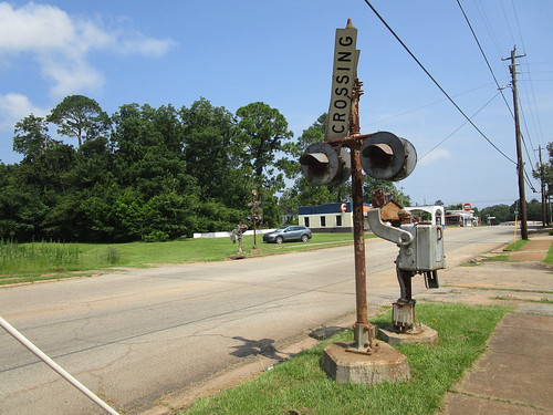
To start-off with though, I'm gonna start with two industrial branch crossings in Chattanooga, TN. The first one of these would be this crossing at the intersection of 38th Street & Central Avenue, on a former NC&StL (later L&N, SBD, and eventually CSX) industrial branch. If you turn the street view camera towards the south, you can see the ties laid across the tracks to mark the end of the active portion of the line. Street view did manage to catch a train on this line back in 2014 with an NS end-cab switcher on it, if you're curious as to how recently it saw use. When I visited the crossing in 2022, one of the signals had been recently struck by a car and left lying between the pair of rusting rails in one corner of it.
IMG_7648 by freebrickproductions, on Flickr
IMG_7649 by freebrickproductions, on Flickr
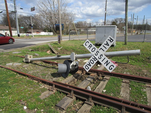
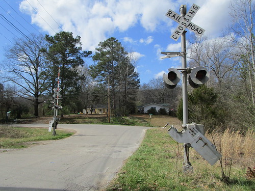
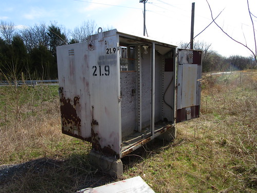
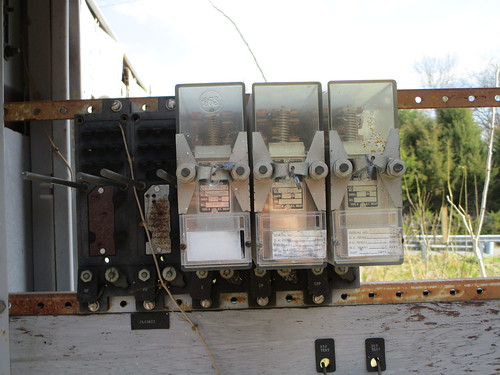
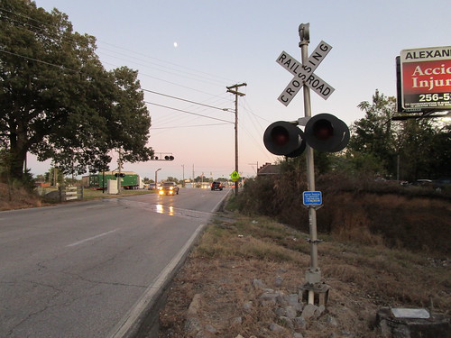
Going to another nearby industrial branch, a former Southern Railway branch this time, you can find this crossing over on 34th Street with a 1970s Southern Railway install guarding it. I'd previously visited it back in 2016, at the time the signals still had their lights facing forwards and the relay case was still powered on, though, sometime after 2019, the lights were turned inwards and I strongly suspect NS turned-off the relay case at the same time.
IMG_7637 by freebrickproductions, on Flickr
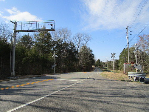
Going south out of Chattanooga and into northwest Georgia, you can find the Chattanooga & Chickamauga Railway (CCKY), which operates over the remaining northern end of the Central of Georgia Railway's mainline to Chattanooga, and runs from Chattanooga to Lyerly. Although most of their line is still in use, the southern end of their line in Lyerly appears to be out of service again, having been brought-back a bit in the 2010s for car storage, but it seems to be out of service again. Regardless, along GA 114 just north of Lyerly you can find this downgraded crossing which still retains a decaying gateless signal from the Central of Georgia. One of the crossbucks here had been wiped-out by a car it seems when I visited in 2022, I have no idea if it has been put back-up or not.
IMG_7307 by freebrickproductions, on Flickr
Going northwest, you can find another out of service & abandoned line running south out of Chattanooga, the former mainline of the Tennessee, Alabama, and Georgia Railway's mainline between Gadsden, AL, and Chattanooga, TN, running through all three states of its namesake. American-Rails.com has a pretty decent article on the history of this line, if you're curious. The section of the main that the CCKY operated up until 2008, which has since had the lease end and reverted to Norfolk Southern's ownership, is still largely in place.
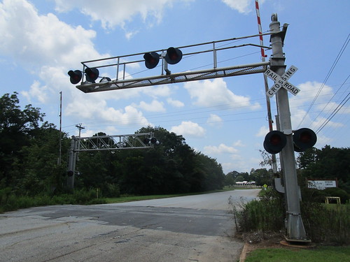
Going south along the line, you first come to this crossing on Central Avenue in Chattanooga, which features a pair of cantilevers installed in the 1980s by the Southern Railway. Sometime between 2016 and 2019, the bells that were at this crossing were removed from this crossing, not sure if they were stolen or intentionally removed by NS. The point at which the line becomes officially out of service is, or at least was, just south of this crossing and is still marked by a pair of ties placed on the track. Of course, given the condition of the rails and the fact that the crossing has been paved over, I think it's safe to say that a train is far from likely of even making it as far as this crossing, at least not intentionally.
IMG_7576 by freebrickproductions, on Flickr
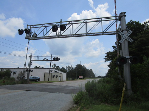
Continuing south across the Georgia state line, you'll come to the first of several crossings along GA 193. This crossing had a pair of gated signals at it, but they were rather quickly removed after the line went dead it seems, leaving just the relay bungalow and signal foundations behind. Strangely, in 2019, NS put-up a crossbuck on one side of the crossing, but the crossbuck itself disappeared later that year, just leaving behind the post and blank ENS sign.
IMG_7564 by freebrickproductions, on Flickr
IMG_7569 by freebrickproductions, on Flickr
IMG_7572 by freebrickproductions, on Flickr
Going south, you'll quickly come across the first of two crossings on Chattanooga Valley Road, which features a pair of gateless signals at, still in overall decent shape. The bell-less signal here is an old TAG install, likely the last crossing signal left from that railroad.
IMG_7552 by freebrickproductions, on Flickr
Continuing further south, you can find this decaying late-70s Southern Railway install at South Avenue.
IMG_7520 by freebrickproductions, on Flickr
Even further south, you can find the other crossing on Chattanooga Valley Road, which used to have a pair of 1970s gated Southern Railway signals but have long since been removed. The remains of the signal foundations and the relay case can still be found here though.
IMG_7508 by freebrickproductions, on Flickr
IMG_7509 by freebrickproductions, on Flickr
The sixth crossing you'll come to on the southbound journey is the second crossing on GA 193, which still features a pair of late-SOU signals with a bit of newer equipment from the CCKY.

IMG_7493 by freebrickproductions, on Flickr
IMG_7480 by freebrickproductions, on Flickr
The next pair of signals you'll come to are at Garretts Chapel Road in High Point, GA. The gated Southern Railway signals here are in pretty decent shape, all things considered.
IMG_7452 by freebrickproductions, on Flickr
Continuing on down towards Kensington, you can still find a quartet of gateless signals guarding the intersection of GA 136 and GA 193, which were installed by the SOU in the 1980s. Some of the plastic GRS light-heads here have gotten pretty beat-up in the 15 years since this part of the TAG died.
IMG_7415 by freebrickproductions, on Flickr
IMG_7435 by freebrickproductions, on Flickr
Going further south on GA 193, you reach the fourth and final crossing along this road. This crossing features a trio of signals installed by the CCKY in the late-90s, and features the newest signals left along this line. The extra gateless signal is provided for visibility around the curve on one side of the crossing.
IMG_7402 by freebrickproductions, on Flickr
IMG_7384 by freebrickproductions, on Flickr
Continuing to the southeast at this point, you reach the next crossing, located over at Kensington Road, with the most recent street-view imagery being from about a year before the last customer on the line closed. This crossing features another pair of Southern Railway signals, with a few replacement pieces from the CCKY in the mid-2000s. A photo from 2004 shows this crossing in action, and, at the time the crossing still retained its original wooden "wishbone"-style gate arms, mechanical bell, and lights. However, as can be seen in the 2004 photo, one of the cantilever mast lights was damaged, which has since been replaced with a newer one. These days, one of the gate mechanisms has been broken into and the signal its on has been swallowed by kudzu. The relay case here has also been broken into and stripped of its copper, though a few GRS relays still remain mounted inside of it.
IMG_7351 by freebrickproductions, on Flickr
IMG_7367 by freebrickproductions, on Flickr
IMG_7357 by freebrickproductions, on Flickr
IMG_7381 by freebrickproductions, on Flickr
IMG_7383 by freebrickproductions, on Flickr
Next, continuing on over to GA 341, you come across another quartet of signals installed by the SOU back in the 1970s. The signals here are a pair of gated masts with a gateless mast and a gateless cantilever installed in the off-side corners to provide extra visibility for the crossing. This one's definitely been dead for along while, all of the lights and both gate arms were already gone back in 2007, with Tracks Out Of Service signs having been installed on the gated signals, one of which has since disappeared. This one also still retains the mounts for the wooden gate arms it would've originally had.
IMG_7338 by freebrickproductions, on Flickr
IMG_7323 by freebrickproductions, on Flickr
Hopping down to the other end of the TAG in Gadsden, you can still find where the NS AG Branch used to extend further than it currently does. Although a small stretch is used to access NS's Siskin Yard in Gadsden and interchange with the Alabama & Tennessee River Railway and a car storage operation in Gadsden, a fair amount of the eastern end of the line, including the southern end of the TAG, hadn't seen a train in many years, and was finally abandoned and torn-out by NS in 2019, with the four signalized crossings on that part being removed at about the same time. Up until that point, however, they were all still hooked-up to power and presumably tested once every month by the local signal maintainer.
Going from east to west, the first signalized crossing you reached was Henry Street, which used to feature a gateless 1980s NS install. When street view went through, the line had just been ripped but the signals were still standing. By the time I made a return visit in October of 2019, however, the signals had come down and were already placed in the small signal dump at the yard in the neighboring city of Attalla.
2018:

IMG_2100 by freebrickproductions, on Flickr
2019:
IMG_1982 by freebrickproductions, on Flickr
Next-up you had 9th Street, which featured a gateless NS install from the mid-90s. Upon my visit in October of 2019, the signal with the bell had been knocked-down and I have no idea what happened to it.
2018:
IMG_2039 by freebrickproductions, on Flickr
2019:
IMG_1993 by freebrickproductions, on Flickr
Then you had this three-way crossing on Tuscaloosa Avenue, which featured a gated NS install from the late-90s or early-2000s, and both the newest and only gated signals along the entire line. When Street View came through, the gate arms were still on the signals, but when I made a visit in October of 2019, the arms had already been removed. This signal would later be reused in Attalla to replace a signal at this crossing over on the still-active NS AGS North District. Amusingly, NS had also replaced two of the gate arms with newer vertically-striped ones at some point. Seems like that was a bit of a waste of money to me.
2018:
IMG_2015 by freebrickproductions, on Flickr
2019:
IMG_2018 by freebrickproductions, on Flickr
Finally, over at 12th Street (AL 211), you had this crossing, which featured a gateless cantilever signal and a gateless mast signal. It seems there may have once been a pair of gateless cantilevers here, almost certainly Southern Railway installs, but one got replaced by a mast signal at some point. This crossing retained the grade across the road a bit longer than the other crossings that were ripped-out on this branch, it seems, likely due to it being an arterial and a state highway. The local freight that works the AG Branch would sometimes pull-up to this crossing for head-room while pulling past the switch to Siskin Yard, but I have no idea if the signals would activate or not during those moves, as I never saw them.
2015, northbound:
IMG_9070 by freebrickproductions, on Flickr
2019, northbound:
IMG_2027 by freebrickproductions, on Flickr
2015, southbound:
IMG_9057 by freebrickproductions, on Flickr
2019, southbound:
IMG_2035 by freebrickproductions, on Flickr
The current end of the AG Branch can be found here, just past Cabot Avenue in Gadsden. Looking at the condition of the tracks there, it doesn't seem a train has reached even that far in years.
Another line that ran through Gadsden was the L&N's Mineral Loop, which ran from CSX's Boyles Yard in Birmingham to Calera, AL, at where the Heart of Dixie Railroad Museum is currently located, via Gadsden, Anniston, Talladega, and Sylacauga. While portions of this line are still in use, such as the section the ATN operates between Ivalee and Wellington, other portions were abandoned and ripped-out. Not too much of the removed sections remain beyond the empty and still-graded ROW other than a few bridges, but Tapawingo Road in Pinson still retains an old rubber grade with the rails where the line once crossed it. I ain't been here yet so sadly no photos of this former crossing.
Going down into southwest Georgia, we've got a trio of lines that the Georgia Southwestern Railroad (GSWR) operated, at least partially. The first of these is the Richland Subdivision, which once ran from Bainbridge to Columbus, GA. This line was previously operated by the Georgia, Florida, & Alabama Railway (GF&A), later the Seaboard Air Line (SAL), Seaboard Cost Line (SCL), Seaboard System (SBD), and CSX, before CSX sold-off the line to the GSWR in 1989. In 1995, when they began to lease the O-Line from NS (more on that later), the Richland Sub between Cuthbert and Cusseta was largely ripped-out and abandoned.
Going from south to north, you quickly find the first abandoned signalized crossing where the line crosses US 27 just north of Cuthbert. This one features a set of fairly modern signals the GSWR would've installed in the 2000s, and are in various states of disrepair. Continuing north to Richland, everything's been ripped-out, but, once you reach downtown Richland, a couple of things of note. Here, you can find where the SAL's Richland Subdivision crossed the SAL's Americus Subdivision once upon a time (more on that later as well), still marked by a diamond left in place long after the Richland Sub was ripped-up. No idea why this was never removed.
PXL_20220313_205010173 by freebrickproductions, on Flickr
Around the diamond you can also find a few other things, like what appears to be the old depot for both lines, which is now Richland's city hall, and an old stripped-out Seaboard radio house, seemingly used now as a storage shed by one of the businesses or the city hall there. Particularly of note, however, is just west of the diamond on the Americus Sub, where you can still find an old railroad post office rotting away. It appears in later years this got used as a storage shed by the railroads, at least for things like locomotive sand. The building will probably collapse at some point though, it's already got a good lean to it.
Abandoned Railroad Post Office by freebrickproductions, on Flickr
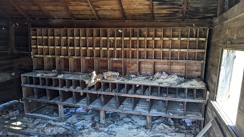
Abandoned Railroad Post Office by freebrickproductions, on Flickr
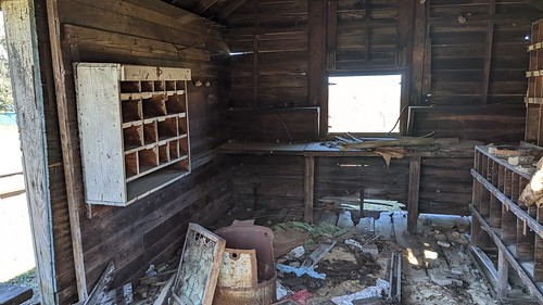
Abandoned Railroad Post Office by freebrickproductions, on Flickr
Continuing north, you won't find much else left until you get to Cusseta and the rails reappear. You won't find any signals until you reach this crossing within the US Military's Fort Moore, though it isn't one you can really go and visit, only getting a passing glance from US 27/US 280/GA 1/GA 520. At this point, the line runs closely parallel to the similarly-dead NS O Line, of which it shared a few crossings with the rest of the way into Columbus. Going into Columbus itself, you first reach this crossing on both the Richland Sub and NS O Line at Conner Road. Next-up is Old Cusseta Road, which still has a lone late-70s SCL signal remaining at it.
Continuing-up to Joy Road, you can find this crossing, which no longer retains anything but used to have another late-70s SCL install. One of the signals was replaced with a reused 90s NS install, however, most likely reused from the neighboring O Line by the GSWR in the early-2010s. The next signalized crossing up, Brennan Road, you can find the remains of another pair of gated signals, another of which seems to be a reused NS signal. At Andrews Road, you can find this crossing that used to be shared with the O Line. While the gateless signal for the Richland Sub is from the 2000s, the gated signal is a classic SAL install, even retaining a cats-eyed crossbuck and 2 Tracks sign! When this part of the Richland Sub died, NS replaced their gateless signal with a gated one, most likely to avoid having to rely on the GSWR signal that had its gate-arm tied-up into the raised position.
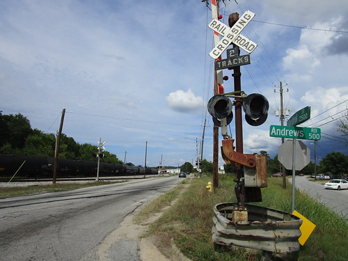
IMG_9924 by freebrickproductions, on Flickr
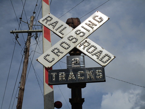
IMG_9926 by freebrickproductions, on Flickr
Going a bit further up, you can find what appears to have been an industrial branch that had a long street-running section along 6th Street. It appears the GSWR still uses it for car storage right up to the eastern end of the street-running though.
Cycling back over to the NS O Line, which ran from Columbus to Americus, GA, we start-out at Andrews Road once again, where you can find a pair of gated signals, one installed by NS in the 90s and one installed by NS in the 2010s. This part of the O Line saw some use as an industrial branch for a while longer than the north end of the neighboring Richland Sub, but according to the FRA's inventory report for this crossing the O Line no longer sees any traffic on the Columbus part of it.
IMG_9944 by freebrickproductions, on Flickr
You can find more signals at all of the other roads mentioned on the Richland Sub in Columbus mentioned above.
Going to the part of the O Line that's very much dead, you first find this 90s NS install at 6th Avenue (GA 26) in Buena Vista. Going into Ellaville, you can find a pair of older gated signals at Broad Street, which was also once US 19. Going over to Oglethorpe Street (GA 26), you can find a pair of gateless 90s NS signals standing guard. Apparently these were reinstalled here, as there used to be a pair of gateless signals from the Central of Georgia up through at least 2008. Continuing down to Andersonville Road (formerly GA 228), you can find more decaying gated signals from the Southern Railway. Strangely, it seems the GSWR chose to repaint the bells here black to match the Safetran mechanical bells the GSWR inherited from the SCL. Going down to GA 271, you can find this crossbuck crossing that still retains a pair of cats-eyed crossbucks on it.
The next signalized crossing on the O Line is this crossing on Bumphead Road just north of Americus, GA, which features a pair of old gated SOU signals at it, which are still in pretty decent shape.
IMG_7953 by freebrickproductions, on Flickr
Going further south, you reach Industrial Boulevard in Americus, where you can find this pair older gated cantilevers installed by NS in the early-90s. The bell-less one is getting fairly overgrown, but the signals here are also in pretty decent shape. This is also the southernmost crossing on the O Line that's dead, the southernmost one on the line at Southerfield Road was also dead, albeit only unused/out of service, but it appears NS got the customer next to it back and now it's in use again.
IMG_8040 by freebrickproductions, on Flickr
IMG_8055 by freebrickproductions, on Flickr
While we're at Americus, we can get to our last of the three dead lines in SW Georgia, the Americus Subdivision. This line was originally built by the Savannah, Americus, & Montgomery Railway, known as the "Savannah Short Line" due to being the shortest route between Savannah, GA, and Montgomery, AL, before becoming part of the SAL in the early-1900s. The western part of the old SAM main between Americus and Montgomery became the Americus Subdivision. When the SAL merged with the Atlantic Coast Line in the late-60s to form the SCL, the line became part of it. As the story goes, in the 1970s, the SCL looked at running double-stack intermodals between Montgomery and Savannah, likely due to being shorter than the ACL's parallel "Bow Line" to the south. However, in Americus, there are (or at least were) a few old overpasses that were too low to run double-stacks, so the SCL approached the city of Americus to replace these with higher overpasses. Unfortunately, the local historical society successfully lobbied to prevent the replacement of the old overpasses, killing the SCL's plans to better utilize the former SAL main to Montgomery. It seems the historical society realized that running one of the railroads out of town was probably a bad idea, and, as I understand it, approached the now-Seaboard System to allow the replacement of the overpasses. Unfortunately for them, from what I've heard, the SBD essentially told them "to stick it where the sun don't shine", and, in 1986, abandoned the Americus Sub between Montgomery and Marht (Cottonton), AL, with the early CSX ripping-out the abandoned stretch in 1987 and 1988. In 1989, the remainder of the line, along with the western portion of the Vidalia Sub, was sold by CSX to the GSWR along with the aforementioned Richland Sub. By the end of the 20th Century, unfortunately, the line from Preston to Marht went dead as well, though, when the GSWR sold the parts of the Americus and Vidalia Subs they owned off to the State of Georgia for them to form the Heart of Georgia Railroad over the trackage, the OOS part also became part of the HOG. It still remains under their ownership to this day, despite them having never used it, as it is also officially out of service.
Going from east to west along the line, we start out in Preston, GA, where we find this formally-signalized crossing at Washington Street (GA 41). According to the FRA, this crossing used to have a pair of gateless signals, most likely installed by the SAL. However, all that's left are the empty signal foundations (with the wiring poking out), relay case, and crossbucks and exempt signage.
IMG_8596 by freebrickproductions, on Flickr
IMG_8599 by freebrickproductions, on Flickr
IMG_8605 by freebrickproductions, on Flickr
IMG_8600 by freebrickproductions, on Flickr
Going west back to Richland, one can still find a pair of gated signals from the SAL rusting away at Wall Street, which I suspect was once part of US 280 and/or GA 520. These rather classic signals are still in pretty decent shape, aside from the one crossbuck, and also still retains the remains of the wooden gate arms still mounted to the WRRS gate mechs there. It seems when the line died, they just sawed off the arms and disconnected the power, leaving everything else to rot.
IMG_8655 by freebrickproductions, on Flickr
To the west, the line also crossed the Richland Bypass (present-day alignment of US 280/GA 520) at-grade. I have no idea what this crossing had originally, as I could not find the DOT number for the crossing, likely due to being added to the line much later, though it seems to have once had cantilevers based on what I suspect is a remaining signal foundation. The crossing's relay case does still survive in the southwest corner though.
IMG_8666 by freebrickproductions, on Flickr
IMG_8664 by freebrickproductions, on Flickr
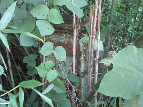
Continuing into Lumpkin, you can find the remains of this crossing at Cotton Street. It was originally a gateless SAL install, though one of the signals was replaced by the SCL at some point in the 1970s, it appears, with the relay case now being buried in the bamboo overgrowth on the east side of the crossing. The remaining SAL signal fell-over at some point in the 2010s and was hauled-off, presumably by scrappers, though the SCL signal still stands, though with a missing crossbuck.
IMG_8669 by freebrickproductions, on Flickr
IMG_8670 by freebrickproductions, on Flickr
IMG_8680 by freebrickproductions, on Flickr
IMG_8685 by freebrickproductions, on Flickr
Further west, you can find the next signalized crossing at GA 39 just outside of Louvale, where all that's left is the decaying remains of a GSWR-installed gated signal, with all that's left of the relay case being the foundations and the signal's partner completely missing in action.
IMG_8704 by freebrickproductions, on Flickr
IMG_8701 by freebrickproductions, on Flickr
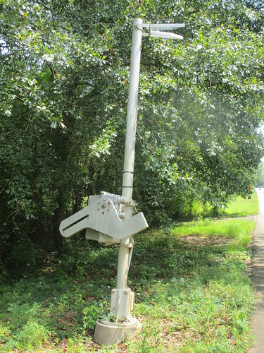
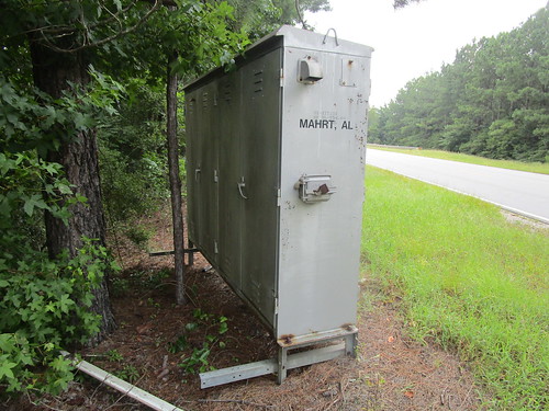
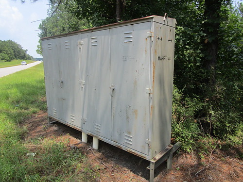
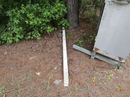
Hopping across the Alabama state line, you reach this crossing on AL 208 in Marht/Cottonton, where all that's left is the relay case and some concrete ties hiding in the trees around the road. The relay case does still retain a few old US&S relays in it though, which is rather neat. When I first visited the former crossing here in 2021, there was also part of an old fiberglass gate arm from the crossing laying in the trees next to the relay case, which may or may not have found its way up here to Huntsville. I have no idea what equipment this crossing had, as this is another crossing I couldn't located a DOT number for.

IMG_8708 by freebrickproductions, on Flickr
IMG_8709 by freebrickproductions, on Flickr
IMG_8724 by freebrickproductions, on Flickr
IMG_8710 by freebrickproductions, on Flickr
IMG_1667 by freebrickproductions, on Flickr
IMG_1669 by freebrickproductions, on Flickr
After this, we get to the part of the line that CSX ripped-out in the 1980s, though some traces of the line can still be found if you know what to look for. The next place of note you reach is Hurtsboro, AL, where, at this nondescript location, the SCL Americus Subdivision once crossed a Central of Georgia line, and do put a pin in this as I intend on cycling back to it briefly a bit further down. An aerial photo from 1995 at this location shows the ex-CofG line still in place, though you can make-out the old rail bed from the Americus Sub cutting across the photo as well.
Going northwest from the former diamond, you reach this former crossing on Goolsby Street, located next to the old Hurtsboro Depot. According to the FRA's inventory report for this crossing, this one was protected by crossbucks, though a power connection and the foundation for a relay case stand close to it. I'm not sure if there were actually some crossing signals here, if there had been a wayside signal on approach to the diamond, or if it was just related to the railroad's radio tower that also stands near this crossing. Strangely, the remains of a wooden crossing gate can be found laying underneath the Hurtsboro depot, no idea where it came from.

IMG_0032 by freebrickproductions, on Flickr
IMG_0035 by freebrickproductions, on Flickr
The next crossing west was the one on Marshall Street. Not much left here other than the slightly newer section of pavement/tarmac where the tracks were ripped-out in the 1980s. According to the FRA, this crossing was also just protected by crossbucks.
IMG_0042 by freebrickproductions, on Flickr
The third former crossing in Hurtsboro along this line that I will share is this one on Main Street. This one had a pair of gateless signals at it, per the FRA, the foundations of which still exist. The power connection for the relay case also still exists, though the foundation of it is nowhere to be seen.
IMG_0016 by freebrickproductions, on Flickr
IMG_0013 by freebrickproductions, on Flickr
IMG_0017 by freebrickproductions, on Flickr
Continuing over to Fort Davis, you can find where the tracks once crossed US Route 29, which was right about here. Nothing is left of the signals themselves here, though, according to the FRA, there used to be a pair of gateless ones protecting the highway. An old telegraph pole from the railroad can also be found here, which has the power connection for the crossing signals left mounted to it. The Fort Davis depot also stands here, one of the few surviving SAM depots along this line, and is in the process of being restored as a museum by a local family. The two doors on the end of the depot are an old Jim Crow-era feature, the one on the right (closer to the tracks) was the whites-only waiting room; the door on the left (further from the tracks) was the non-whites-only waiting room.
Over at Hardaway, just east of the community you'll find where the Americus Sub once crossed CR 23. Nothing is left of this crossing either, other than a power connection for the gateless signals that once stood here, per the FRA, and one of the old signal foundations left discarded in the briar just east of the crossing. Just east of the crossing, you can also find the small concrete block structure that once housed the Hardaway defect detector, located at milepost SL802.9 along the line, and is one of three defect detectors that the SAL installed along the line in the 1960s (all three of which still stand, in varying states of vandalism). Nothing is left of the old defect detector itself inside, unfortunately, all that you'll find are some lightning arrestors mounted on the wall in a corner of it and one of the screen doors laying underneath a pile of the decaying insulation from the roof, which I'm fairly certain is asbestos. The old power connection to the detector also still stands next to it. Strangely, the old ROW next to the detector was getting cleared-out earlier this year, though I'm not entirely sure why. I'm guessing the owner of the land just south of the line wanted a new driveway, as not much of the ROW elsewhere, even on the other side of CR 23, hasn't been getting the same treatment. Admittedly, I have no idea if the old detector house still stands, but I hope to confirm soon-ish if it does or not.
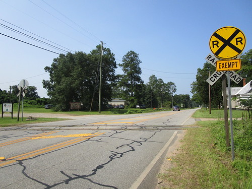
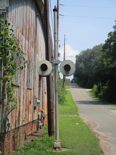
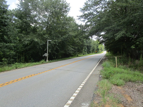
Once you reach Montgomery, the rails reappear just past AL 110, though for the next few miles all that you'll find are crossbucks with exempt signs posted underneath them, such as at this crossing. It appears that, after this part of the Americus Sub was severed in the 80s, CSX turned it into the Americus Branch. The eastern end of the branch had gone dead though, and was sold off to a local railfan who at least intended on starting an excursion railroad over this part of the line, causing the decaying Seaboard and CSX signals along the section in question to be removed. I have no idea if those plans for an excursion railroad will ever go through at this point though, I seem to recall seeing where someone shared an obituary with the person who intended to do it in either the Alabama Rails or Alabama Railroad History group on Facebook a while back, with the obituary being from a few years ago. The eastern end of the Americus Branch does still see a bit of use though, for occasionally accessing the Progress Rail facility on the east side of Montgomery, with a police escort across the crossings when done so. From about here west to the CSX S&N Yard, CSX still owns this section Americus Sub, the only section they retain, and has a local that trundles out to the industrial park there and back about twice a week, as I understand it.
Circling back to the CofG line crossed at Hurtsboro, that line was once the Central of Georgia's line from Columbus, GA, to Troy, AL, and eventually Andalusia, AL. The line was partially dismantled in the 80s it appears, with the isolated section in Troy becoming the Conecuh Valley Railroad, while NS retained the northern end of the line to Hurtsboro. In 1995, the line was sold to the Pine Belt Southern, a short-lived shortline that operated two separate lines in this area (the other being the Roanoke Line from Opelika, AL, to Roanoke, AL). Sadly, it would not last, as the customers on the line either shut down or switched to shipping via road by the end of 2000, with the line being officially abandoned June 1st, 2003 and ripped-up after. On the west side of Hurtsboro, however, you can still find where the line once crossed AL 51, which is still marked with the abandoned power connection standing along the highway. An aerial photo from 1995, likely about the time of the sale by NS, also shows the gated signals that once stood at this crossing, which appear to be an 80s or early-90s Safetran install by NS.
I'm probably wrap-up my post here, even though there are plenty more lines I could discuss, such as the Norfolk Southern Dublin District (Tennille, GA to Dublin, GA) and the remains of the Norfolk & Western's Durham Belt in Durham, NC, as it's already long enough as it is and it's also already just about 3 AM here in Huntsville and I kinda want to get some sleep at this point. At the very least, I hope y'all found this rather long post useful, entertaining, and/or informative in some regard.
To start-off with though, I'm gonna start with two industrial branch crossings in Chattanooga, TN. The first one of these would be this crossing at the intersection of 38th Street & Central Avenue, on a former NC&StL (later L&N, SBD, and eventually CSX) industrial branch. If you turn the street view camera towards the south, you can see the ties laid across the tracks to mark the end of the active portion of the line. Street view did manage to catch a train on this line back in 2014 with an NS end-cab switcher on it, if you're curious as to how recently it saw use. When I visited the crossing in 2022, one of the signals had been recently struck by a car and left lying between the pair of rusting rails in one corner of it.
IMG_7648 by freebrickproductions, on Flickr
IMG_7649 by freebrickproductions, on Flickr
Going to another nearby industrial branch, a former Southern Railway branch this time, you can find this crossing over on 34th Street with a 1970s Southern Railway install guarding it. I'd previously visited it back in 2016, at the time the signals still had their lights facing forwards and the relay case was still powered on, though, sometime after 2019, the lights were turned inwards and I strongly suspect NS turned-off the relay case at the same time.
IMG_7637 by freebrickproductions, on Flickr
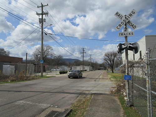
Going south out of Chattanooga and into northwest Georgia, you can find the Chattanooga & Chickamauga Railway (CCKY), which operates over the remaining northern end of the Central of Georgia Railway's mainline to Chattanooga, and runs from Chattanooga to Lyerly. Although most of their line is still in use, the southern end of their line in Lyerly appears to be out of service again, having been brought-back a bit in the 2010s for car storage, but it seems to be out of service again. Regardless, along GA 114 just north of Lyerly you can find this downgraded crossing which still retains a decaying gateless signal from the Central of Georgia. One of the crossbucks here had been wiped-out by a car it seems when I visited in 2022, I have no idea if it has been put back-up or not.
IMG_7307 by freebrickproductions, on Flickr
Going northwest, you can find another out of service & abandoned line running south out of Chattanooga, the former mainline of the Tennessee, Alabama, and Georgia Railway's mainline between Gadsden, AL, and Chattanooga, TN, running through all three states of its namesake. American-Rails.com has a pretty decent article on the history of this line, if you're curious. The section of the main that the CCKY operated up until 2008, which has since had the lease end and reverted to Norfolk Southern's ownership, is still largely in place.
Going south along the line, you first come to this crossing on Central Avenue in Chattanooga, which features a pair of cantilevers installed in the 1980s by the Southern Railway. Sometime between 2016 and 2019, the bells that were at this crossing were removed from this crossing, not sure if they were stolen or intentionally removed by NS. The point at which the line becomes officially out of service is, or at least was, just south of this crossing and is still marked by a pair of ties placed on the track. Of course, given the condition of the rails and the fact that the crossing has been paved over, I think it's safe to say that a train is far from likely of even making it as far as this crossing, at least not intentionally.
IMG_7576 by freebrickproductions, on Flickr
Continuing south across the Georgia state line, you'll come to the first of several crossings along GA 193. This crossing had a pair of gated signals at it, but they were rather quickly removed after the line went dead it seems, leaving just the relay bungalow and signal foundations behind. Strangely, in 2019, NS put-up a crossbuck on one side of the crossing, but the crossbuck itself disappeared later that year, just leaving behind the post and blank ENS sign.
IMG_7564 by freebrickproductions, on Flickr
IMG_7569 by freebrickproductions, on Flickr
IMG_7572 by freebrickproductions, on Flickr
Going south, you'll quickly come across the first of two crossings on Chattanooga Valley Road, which features a pair of gateless signals at, still in overall decent shape. The bell-less signal here is an old TAG install, likely the last crossing signal left from that railroad.
IMG_7552 by freebrickproductions, on Flickr
Continuing further south, you can find this decaying late-70s Southern Railway install at South Avenue.
IMG_7520 by freebrickproductions, on Flickr
Even further south, you can find the other crossing on Chattanooga Valley Road, which used to have a pair of 1970s gated Southern Railway signals but have long since been removed. The remains of the signal foundations and the relay case can still be found here though.
IMG_7508 by freebrickproductions, on Flickr
IMG_7509 by freebrickproductions, on Flickr
The sixth crossing you'll come to on the southbound journey is the second crossing on GA 193, which still features a pair of late-SOU signals with a bit of newer equipment from the CCKY.
IMG_7493 by freebrickproductions, on Flickr
IMG_7480 by freebrickproductions, on Flickr
The next pair of signals you'll come to are at Garretts Chapel Road in High Point, GA. The gated Southern Railway signals here are in pretty decent shape, all things considered.
IMG_7452 by freebrickproductions, on Flickr
Continuing on down towards Kensington, you can still find a quartet of gateless signals guarding the intersection of GA 136 and GA 193, which were installed by the SOU in the 1980s. Some of the plastic GRS light-heads here have gotten pretty beat-up in the 15 years since this part of the TAG died.
IMG_7415 by freebrickproductions, on Flickr
IMG_7435 by freebrickproductions, on Flickr
Going further south on GA 193, you reach the fourth and final crossing along this road. This crossing features a trio of signals installed by the CCKY in the late-90s, and features the newest signals left along this line. The extra gateless signal is provided for visibility around the curve on one side of the crossing.
IMG_7402 by freebrickproductions, on Flickr
IMG_7384 by freebrickproductions, on Flickr
Continuing to the southeast at this point, you reach the next crossing, located over at Kensington Road, with the most recent street-view imagery being from about a year before the last customer on the line closed. This crossing features another pair of Southern Railway signals, with a few replacement pieces from the CCKY in the mid-2000s. A photo from 2004 shows this crossing in action, and, at the time the crossing still retained its original wooden "wishbone"-style gate arms, mechanical bell, and lights. However, as can be seen in the 2004 photo, one of the cantilever mast lights was damaged, which has since been replaced with a newer one. These days, one of the gate mechanisms has been broken into and the signal its on has been swallowed by kudzu. The relay case here has also been broken into and stripped of its copper, though a few GRS relays still remain mounted inside of it.
IMG_7351 by freebrickproductions, on Flickr
IMG_7367 by freebrickproductions, on Flickr
IMG_7357 by freebrickproductions, on Flickr
IMG_7381 by freebrickproductions, on Flickr
IMG_7383 by freebrickproductions, on Flickr
Next, continuing on over to GA 341, you come across another quartet of signals installed by the SOU back in the 1970s. The signals here are a pair of gated masts with a gateless mast and a gateless cantilever installed in the off-side corners to provide extra visibility for the crossing. This one's definitely been dead for along while, all of the lights and both gate arms were already gone back in 2007, with Tracks Out Of Service signs having been installed on the gated signals, one of which has since disappeared. This one also still retains the mounts for the wooden gate arms it would've originally had.
IMG_7338 by freebrickproductions, on Flickr
IMG_7323 by freebrickproductions, on Flickr
Hopping down to the other end of the TAG in Gadsden, you can still find where the NS AG Branch used to extend further than it currently does. Although a small stretch is used to access NS's Siskin Yard in Gadsden and interchange with the Alabama & Tennessee River Railway and a car storage operation in Gadsden, a fair amount of the eastern end of the line, including the southern end of the TAG, hadn't seen a train in many years, and was finally abandoned and torn-out by NS in 2019, with the four signalized crossings on that part being removed at about the same time. Up until that point, however, they were all still hooked-up to power and presumably tested once every month by the local signal maintainer.
Going from east to west, the first signalized crossing you reached was Henry Street, which used to feature a gateless 1980s NS install. When street view went through, the line had just been ripped but the signals were still standing. By the time I made a return visit in October of 2019, however, the signals had come down and were already placed in the small signal dump at the yard in the neighboring city of Attalla.
2018:
IMG_2100 by freebrickproductions, on Flickr
2019:
IMG_1982 by freebrickproductions, on Flickr
Next-up you had 9th Street, which featured a gateless NS install from the mid-90s. Upon my visit in October of 2019, the signal with the bell had been knocked-down and I have no idea what happened to it.
2018:
IMG_2039 by freebrickproductions, on Flickr
2019:
IMG_1993 by freebrickproductions, on Flickr
Then you had this three-way crossing on Tuscaloosa Avenue, which featured a gated NS install from the late-90s or early-2000s, and both the newest and only gated signals along the entire line. When Street View came through, the gate arms were still on the signals, but when I made a visit in October of 2019, the arms had already been removed. This signal would later be reused in Attalla to replace a signal at this crossing over on the still-active NS AGS North District. Amusingly, NS had also replaced two of the gate arms with newer vertically-striped ones at some point. Seems like that was a bit of a waste of money to me.
2018:
IMG_2015 by freebrickproductions, on Flickr
2019:
IMG_2018 by freebrickproductions, on Flickr
Finally, over at 12th Street (AL 211), you had this crossing, which featured a gateless cantilever signal and a gateless mast signal. It seems there may have once been a pair of gateless cantilevers here, almost certainly Southern Railway installs, but one got replaced by a mast signal at some point. This crossing retained the grade across the road a bit longer than the other crossings that were ripped-out on this branch, it seems, likely due to it being an arterial and a state highway. The local freight that works the AG Branch would sometimes pull-up to this crossing for head-room while pulling past the switch to Siskin Yard, but I have no idea if the signals would activate or not during those moves, as I never saw them.
2015, northbound:
IMG_9070 by freebrickproductions, on Flickr
2019, northbound:
IMG_2027 by freebrickproductions, on Flickr
2015, southbound:
IMG_9057 by freebrickproductions, on Flickr
2019, southbound:
IMG_2035 by freebrickproductions, on Flickr
The current end of the AG Branch can be found here, just past Cabot Avenue in Gadsden. Looking at the condition of the tracks there, it doesn't seem a train has reached even that far in years.
Another line that ran through Gadsden was the L&N's Mineral Loop, which ran from CSX's Boyles Yard in Birmingham to Calera, AL, at where the Heart of Dixie Railroad Museum is currently located, via Gadsden, Anniston, Talladega, and Sylacauga. While portions of this line are still in use, such as the section the ATN operates between Ivalee and Wellington, other portions were abandoned and ripped-out. Not too much of the removed sections remain beyond the empty and still-graded ROW other than a few bridges, but Tapawingo Road in Pinson still retains an old rubber grade with the rails where the line once crossed it. I ain't been here yet so sadly no photos of this former crossing.
Going down into southwest Georgia, we've got a trio of lines that the Georgia Southwestern Railroad (GSWR) operated, at least partially. The first of these is the Richland Subdivision, which once ran from Bainbridge to Columbus, GA. This line was previously operated by the Georgia, Florida, & Alabama Railway (GF&A), later the Seaboard Air Line (SAL), Seaboard Cost Line (SCL), Seaboard System (SBD), and CSX, before CSX sold-off the line to the GSWR in 1989. In 1995, when they began to lease the O-Line from NS (more on that later), the Richland Sub between Cuthbert and Cusseta was largely ripped-out and abandoned.
Going from south to north, you quickly find the first abandoned signalized crossing where the line crosses US 27 just north of Cuthbert. This one features a set of fairly modern signals the GSWR would've installed in the 2000s, and are in various states of disrepair. Continuing north to Richland, everything's been ripped-out, but, once you reach downtown Richland, a couple of things of note. Here, you can find where the SAL's Richland Subdivision crossed the SAL's Americus Subdivision once upon a time (more on that later as well), still marked by a diamond left in place long after the Richland Sub was ripped-up. No idea why this was never removed.
PXL_20220313_205010173 by freebrickproductions, on Flickr
Around the diamond you can also find a few other things, like what appears to be the old depot for both lines, which is now Richland's city hall, and an old stripped-out Seaboard radio house, seemingly used now as a storage shed by one of the businesses or the city hall there. Particularly of note, however, is just west of the diamond on the Americus Sub, where you can still find an old railroad post office rotting away. It appears in later years this got used as a storage shed by the railroads, at least for things like locomotive sand. The building will probably collapse at some point though, it's already got a good lean to it.
Abandoned Railroad Post Office by freebrickproductions, on Flickr
Abandoned Railroad Post Office by freebrickproductions, on Flickr
Abandoned Railroad Post Office by freebrickproductions, on Flickr
Continuing north, you won't find much else left until you get to Cusseta and the rails reappear. You won't find any signals until you reach this crossing within the US Military's Fort Moore, though it isn't one you can really go and visit, only getting a passing glance from US 27/US 280/GA 1/GA 520. At this point, the line runs closely parallel to the similarly-dead NS O Line, of which it shared a few crossings with the rest of the way into Columbus. Going into Columbus itself, you first reach this crossing on both the Richland Sub and NS O Line at Conner Road. Next-up is Old Cusseta Road, which still has a lone late-70s SCL signal remaining at it.
Continuing-up to Joy Road, you can find this crossing, which no longer retains anything but used to have another late-70s SCL install. One of the signals was replaced with a reused 90s NS install, however, most likely reused from the neighboring O Line by the GSWR in the early-2010s. The next signalized crossing up, Brennan Road, you can find the remains of another pair of gated signals, another of which seems to be a reused NS signal. At Andrews Road, you can find this crossing that used to be shared with the O Line. While the gateless signal for the Richland Sub is from the 2000s, the gated signal is a classic SAL install, even retaining a cats-eyed crossbuck and 2 Tracks sign! When this part of the Richland Sub died, NS replaced their gateless signal with a gated one, most likely to avoid having to rely on the GSWR signal that had its gate-arm tied-up into the raised position.
IMG_9924 by freebrickproductions, on Flickr
IMG_9926 by freebrickproductions, on Flickr
Going a bit further up, you can find what appears to have been an industrial branch that had a long street-running section along 6th Street. It appears the GSWR still uses it for car storage right up to the eastern end of the street-running though.
Cycling back over to the NS O Line, which ran from Columbus to Americus, GA, we start-out at Andrews Road once again, where you can find a pair of gated signals, one installed by NS in the 90s and one installed by NS in the 2010s. This part of the O Line saw some use as an industrial branch for a while longer than the north end of the neighboring Richland Sub, but according to the FRA's inventory report for this crossing the O Line no longer sees any traffic on the Columbus part of it.
IMG_9944 by freebrickproductions, on Flickr
You can find more signals at all of the other roads mentioned on the Richland Sub in Columbus mentioned above.
Going to the part of the O Line that's very much dead, you first find this 90s NS install at 6th Avenue (GA 26) in Buena Vista. Going into Ellaville, you can find a pair of older gated signals at Broad Street, which was also once US 19. Going over to Oglethorpe Street (GA 26), you can find a pair of gateless 90s NS signals standing guard. Apparently these were reinstalled here, as there used to be a pair of gateless signals from the Central of Georgia up through at least 2008. Continuing down to Andersonville Road (formerly GA 228), you can find more decaying gated signals from the Southern Railway. Strangely, it seems the GSWR chose to repaint the bells here black to match the Safetran mechanical bells the GSWR inherited from the SCL. Going down to GA 271, you can find this crossbuck crossing that still retains a pair of cats-eyed crossbucks on it.
The next signalized crossing on the O Line is this crossing on Bumphead Road just north of Americus, GA, which features a pair of old gated SOU signals at it, which are still in pretty decent shape.
IMG_7953 by freebrickproductions, on Flickr
Going further south, you reach Industrial Boulevard in Americus, where you can find this pair older gated cantilevers installed by NS in the early-90s. The bell-less one is getting fairly overgrown, but the signals here are also in pretty decent shape. This is also the southernmost crossing on the O Line that's dead, the southernmost one on the line at Southerfield Road was also dead, albeit only unused/out of service, but it appears NS got the customer next to it back and now it's in use again.
IMG_8040 by freebrickproductions, on Flickr
IMG_8055 by freebrickproductions, on Flickr
While we're at Americus, we can get to our last of the three dead lines in SW Georgia, the Americus Subdivision. This line was originally built by the Savannah, Americus, & Montgomery Railway, known as the "Savannah Short Line" due to being the shortest route between Savannah, GA, and Montgomery, AL, before becoming part of the SAL in the early-1900s. The western part of the old SAM main between Americus and Montgomery became the Americus Subdivision. When the SAL merged with the Atlantic Coast Line in the late-60s to form the SCL, the line became part of it. As the story goes, in the 1970s, the SCL looked at running double-stack intermodals between Montgomery and Savannah, likely due to being shorter than the ACL's parallel "Bow Line" to the south. However, in Americus, there are (or at least were) a few old overpasses that were too low to run double-stacks, so the SCL approached the city of Americus to replace these with higher overpasses. Unfortunately, the local historical society successfully lobbied to prevent the replacement of the old overpasses, killing the SCL's plans to better utilize the former SAL main to Montgomery. It seems the historical society realized that running one of the railroads out of town was probably a bad idea, and, as I understand it, approached the now-Seaboard System to allow the replacement of the overpasses. Unfortunately for them, from what I've heard, the SBD essentially told them "to stick it where the sun don't shine", and, in 1986, abandoned the Americus Sub between Montgomery and Marht (Cottonton), AL, with the early CSX ripping-out the abandoned stretch in 1987 and 1988. In 1989, the remainder of the line, along with the western portion of the Vidalia Sub, was sold by CSX to the GSWR along with the aforementioned Richland Sub. By the end of the 20th Century, unfortunately, the line from Preston to Marht went dead as well, though, when the GSWR sold the parts of the Americus and Vidalia Subs they owned off to the State of Georgia for them to form the Heart of Georgia Railroad over the trackage, the OOS part also became part of the HOG. It still remains under their ownership to this day, despite them having never used it, as it is also officially out of service.
Going from east to west along the line, we start out in Preston, GA, where we find this formally-signalized crossing at Washington Street (GA 41). According to the FRA, this crossing used to have a pair of gateless signals, most likely installed by the SAL. However, all that's left are the empty signal foundations (with the wiring poking out), relay case, and crossbucks and exempt signage.
IMG_8596 by freebrickproductions, on Flickr
IMG_8599 by freebrickproductions, on Flickr
IMG_8605 by freebrickproductions, on Flickr
IMG_8600 by freebrickproductions, on Flickr
Going west back to Richland, one can still find a pair of gated signals from the SAL rusting away at Wall Street, which I suspect was once part of US 280 and/or GA 520. These rather classic signals are still in pretty decent shape, aside from the one crossbuck, and also still retains the remains of the wooden gate arms still mounted to the WRRS gate mechs there. It seems when the line died, they just sawed off the arms and disconnected the power, leaving everything else to rot.
IMG_8655 by freebrickproductions, on Flickr
To the west, the line also crossed the Richland Bypass (present-day alignment of US 280/GA 520) at-grade. I have no idea what this crossing had originally, as I could not find the DOT number for the crossing, likely due to being added to the line much later, though it seems to have once had cantilevers based on what I suspect is a remaining signal foundation. The crossing's relay case does still survive in the southwest corner though.
IMG_8666 by freebrickproductions, on Flickr
IMG_8664 by freebrickproductions, on Flickr
Continuing into Lumpkin, you can find the remains of this crossing at Cotton Street. It was originally a gateless SAL install, though one of the signals was replaced by the SCL at some point in the 1970s, it appears, with the relay case now being buried in the bamboo overgrowth on the east side of the crossing. The remaining SAL signal fell-over at some point in the 2010s and was hauled-off, presumably by scrappers, though the SCL signal still stands, though with a missing crossbuck.
IMG_8669 by freebrickproductions, on Flickr
IMG_8670 by freebrickproductions, on Flickr
IMG_8680 by freebrickproductions, on Flickr
IMG_8685 by freebrickproductions, on Flickr
Further west, you can find the next signalized crossing at GA 39 just outside of Louvale, where all that's left is the decaying remains of a GSWR-installed gated signal, with all that's left of the relay case being the foundations and the signal's partner completely missing in action.
IMG_8704 by freebrickproductions, on Flickr
IMG_8701 by freebrickproductions, on Flickr
Hopping across the Alabama state line, you reach this crossing on AL 208 in Marht/Cottonton, where all that's left is the relay case and some concrete ties hiding in the trees around the road. The relay case does still retain a few old US&S relays in it though, which is rather neat. When I first visited the former crossing here in 2021, there was also part of an old fiberglass gate arm from the crossing laying in the trees next to the relay case, which may or may not have found its way up here to Huntsville.
IMG_8708 by freebrickproductions, on Flickr
IMG_8709 by freebrickproductions, on Flickr
IMG_8724 by freebrickproductions, on Flickr
IMG_8710 by freebrickproductions, on Flickr
IMG_1667 by freebrickproductions, on Flickr
IMG_1669 by freebrickproductions, on Flickr
After this, we get to the part of the line that CSX ripped-out in the 1980s, though some traces of the line can still be found if you know what to look for. The next place of note you reach is Hurtsboro, AL, where, at this nondescript location, the SCL Americus Subdivision once crossed a Central of Georgia line, and do put a pin in this as I intend on cycling back to it briefly a bit further down. An aerial photo from 1995 at this location shows the ex-CofG line still in place, though you can make-out the old rail bed from the Americus Sub cutting across the photo as well.
Going northwest from the former diamond, you reach this former crossing on Goolsby Street, located next to the old Hurtsboro Depot. According to the FRA's inventory report for this crossing, this one was protected by crossbucks, though a power connection and the foundation for a relay case stand close to it. I'm not sure if there were actually some crossing signals here, if there had been a wayside signal on approach to the diamond, or if it was just related to the railroad's radio tower that also stands near this crossing. Strangely, the remains of a wooden crossing gate can be found laying underneath the Hurtsboro depot, no idea where it came from.
IMG_0032 by freebrickproductions, on Flickr
IMG_0035 by freebrickproductions, on Flickr
The next crossing west was the one on Marshall Street. Not much left here other than the slightly newer section of pavement/tarmac where the tracks were ripped-out in the 1980s. According to the FRA, this crossing was also just protected by crossbucks.
IMG_0042 by freebrickproductions, on Flickr
The third former crossing in Hurtsboro along this line that I will share is this one on Main Street. This one had a pair of gateless signals at it, per the FRA, the foundations of which still exist. The power connection for the relay case also still exists, though the foundation of it is nowhere to be seen.
IMG_0016 by freebrickproductions, on Flickr
IMG_0013 by freebrickproductions, on Flickr
IMG_0017 by freebrickproductions, on Flickr
Continuing over to Fort Davis, you can find where the tracks once crossed US Route 29, which was right about here. Nothing is left of the signals themselves here, though, according to the FRA, there used to be a pair of gateless ones protecting the highway. An old telegraph pole from the railroad can also be found here, which has the power connection for the crossing signals left mounted to it. The Fort Davis depot also stands here, one of the few surviving SAM depots along this line, and is in the process of being restored as a museum by a local family. The two doors on the end of the depot are an old Jim Crow-era feature, the one on the right (closer to the tracks) was the whites-only waiting room; the door on the left (further from the tracks) was the non-whites-only waiting room.
Over at Hardaway, just east of the community you'll find where the Americus Sub once crossed CR 23. Nothing is left of this crossing either, other than a power connection for the gateless signals that once stood here, per the FRA, and one of the old signal foundations left discarded in the briar just east of the crossing. Just east of the crossing, you can also find the small concrete block structure that once housed the Hardaway defect detector, located at milepost SL802.9 along the line, and is one of three defect detectors that the SAL installed along the line in the 1960s (all three of which still stand, in varying states of vandalism). Nothing is left of the old defect detector itself inside, unfortunately, all that you'll find are some lightning arrestors mounted on the wall in a corner of it and one of the screen doors laying underneath a pile of the decaying insulation from the roof, which I'm fairly certain is asbestos. The old power connection to the detector also still stands next to it. Strangely, the old ROW next to the detector was getting cleared-out earlier this year, though I'm not entirely sure why. I'm guessing the owner of the land just south of the line wanted a new driveway, as not much of the ROW elsewhere, even on the other side of CR 23, hasn't been getting the same treatment. Admittedly, I have no idea if the old detector house still stands, but I hope to confirm soon-ish if it does or not.
Once you reach Montgomery, the rails reappear just past AL 110, though for the next few miles all that you'll find are crossbucks with exempt signs posted underneath them, such as at this crossing. It appears that, after this part of the Americus Sub was severed in the 80s, CSX turned it into the Americus Branch. The eastern end of the branch had gone dead though, and was sold off to a local railfan who at least intended on starting an excursion railroad over this part of the line, causing the decaying Seaboard and CSX signals along the section in question to be removed. I have no idea if those plans for an excursion railroad will ever go through at this point though, I seem to recall seeing where someone shared an obituary with the person who intended to do it in either the Alabama Rails or Alabama Railroad History group on Facebook a while back, with the obituary being from a few years ago. The eastern end of the Americus Branch does still see a bit of use though, for occasionally accessing the Progress Rail facility on the east side of Montgomery, with a police escort across the crossings when done so. From about here west to the CSX S&N Yard, CSX still owns this section Americus Sub, the only section they retain, and has a local that trundles out to the industrial park there and back about twice a week, as I understand it.
Circling back to the CofG line crossed at Hurtsboro, that line was once the Central of Georgia's line from Columbus, GA, to Troy, AL, and eventually Andalusia, AL. The line was partially dismantled in the 80s it appears, with the isolated section in Troy becoming the Conecuh Valley Railroad, while NS retained the northern end of the line to Hurtsboro. In 1995, the line was sold to the Pine Belt Southern, a short-lived shortline that operated two separate lines in this area (the other being the Roanoke Line from Opelika, AL, to Roanoke, AL). Sadly, it would not last, as the customers on the line either shut down or switched to shipping via road by the end of 2000, with the line being officially abandoned June 1st, 2003 and ripped-up after. On the west side of Hurtsboro, however, you can still find where the line once crossed AL 51, which is still marked with the abandoned power connection standing along the highway. An aerial photo from 1995, likely about the time of the sale by NS, also shows the gated signals that once stood at this crossing, which appear to be an 80s or early-90s Safetran install by NS.
I'm probably wrap-up my post here, even though there are plenty more lines I could discuss, such as the Norfolk Southern Dublin District (Tennille, GA to Dublin, GA) and the remains of the Norfolk & Western's Durham Belt in Durham, NC, as it's already long enough as it is and it's also already just about 3 AM here in Huntsville and I kinda want to get some sleep at this point. At the very least, I hope y'all found this rather long post useful, entertaining, and/or informative in some regard.
Last edited by freebrickproductions on Mon Dec 25, 2023 01:44, edited 1 time in total.
Probably busy documenting grade crossings in the southeastern United States.
(They/Them)
(They/Them)
-
FleetlinePhil

- Member
- Posts: 2103
- Joined: Fri Sep 08, 2017 11:26
- Location: Calder Valley
Re: Abandoned Level Crossings
I agree about the functions, but it was applied to all terminating tracks at Piccadilly, and indeed elsewhere like Bradford Interchange, not just the ones with run-round facilities. Incidentally, I'm not sure when Piccadilly - London services last operated in the way you describe? From my interest starting in the mid 1970s to when the Pendolinos started, I have only ever seen them operated by coupling a fresh locomotive on the front. The "trapped" loco that had brought them in would follow the departed train out and sit in a siding in the station throat, becoming the loco for the next outbound train an hour later.Barkstar wrote: ↑Thu Dec 14, 2023 11:23It's stainless steel welded on. It usually has two functions - mostly it is to ensure the track circuit registers the presence of the train and it also makes a right racket in the cab. They had it at Manchester Piccadilly when the London trains were loco hauled. They had to run round the coaches, which needed a set of points near the buffers. The loco needed to pull up to the buffers to clear the points but that track would be greasy and not very polished so the welding ensured good contact to show the signalman he could switch the points.wallmeerkat wrote: ↑Thu Dec 14, 2023 10:292009 and 2012 GSV seems to show it crossing. What are the zigzags on the rails for?Octaviadriver wrote: ↑Wed Dec 13, 2023 16:57 This one is on Burryport Road on the southern edge of Northampton that was part of the line from Northampton to Peterborough. The last date the crossing existed on Streetview was October 2012. It seems odd that there is a short stretch of line intact complete with a siding that still seems to be in use, though the line has been severed, that can be seen from the satellite view. There were a number of level crossings on this line where it ran along the Nene Valley.
https://maps.app.goo.gl/cwqdT7YGHWN5CDYHA
https://www.google.co.uk/maps/@52.22292 ... ?entry=ttu
Re: Abandoned Level Crossings
Would it also improve railhead adhesion - or perhaps paradoxically (to people used to rubber tyres) make it worse?Barkstar wrote: ↑Thu Dec 14, 2023 11:23It's stainless steel welded on. It usually has two functions - mostly it is to ensure the track circuit registers the presence of the train and it also makes a right racket in the cab. They had it at Manchester Piccadilly when the London trains were loco hauled. They had to run round the coaches, which needed a set of points near the buffers. The loco needed to pull up to the buffers to clear the points but that track would be greasy and not very polished so the welding ensured good contact to show the signalman he could switch the points.wallmeerkat wrote: ↑Thu Dec 14, 2023 10:292009 and 2012 GSV seems to show it crossing. What are the zigzags on the rails for?Octaviadriver wrote: ↑Wed Dec 13, 2023 16:57 This one is on Burryport Road on the southern edge of Northampton that was part of the line from Northampton to Peterborough. The last date the crossing existed on Streetview was October 2012. It seems odd that there is a short stretch of line intact complete with a siding that still seems to be in use, though the line has been severed, that can be seen from the satellite view. There were a number of level crossings on this line where it ran along the Nene Valley.
https://maps.app.goo.gl/cwqdT7YGHWN5CDYHA
https://www.google.co.uk/maps/@52.22292 ... ?entry=ttu
-
wallmeerkat
- Member
- Posts: 1334
- Joined: Fri Apr 20, 2018 16:49
- Location: County Down
Re: Abandoned Level Crossings
Here's one, it's not only trains...
The Airbus factory in Broughton manufactures wings. The 380 wings were so massive that they needed transported by barge. To get to the barge they needed a platform that briefly used a public road, so they had a barrier controlled crossing
https://www.google.com/maps/@53.1889036 ... ?entry=ttu
And while it doesn't have rails, you can see the strips in the tarmac of the B5129 where a(-n electromagnetic?) guide was installed to help guide it over the relatively narrow bridge https://www.google.com/maps/@53.1891521 ... ?entry=ttu
380 production ended in 2020, though the river could be used again - https://www.deeside.com/airbus-could-be ... mbly-line/
Re: Abandoned Level Crossings
These are my pics of the vehicle going over the bridge at Beeches farm to collect a wing at the river berth and the barge going under the bascule bridge at Queensferry. I managed to photograph the last barge in 2020 but orders for A380s have finished i think. I'm sure the barge and other equipment is in storage in case production starts up again.
- Attachments
-
-

Re: Abandoned Level Crossings
That crossing from the other end
https://maps.app.goo.gl/G3KzXFu49nA3nfhh7
Is it crying because it didn't have a job any more?
https://maps.app.goo.gl/G3KzXFu49nA3nfhh7
Is it crying because it didn't have a job any more?
-
swissferry
- Member
- Posts: 332
- Joined: Tue Aug 22, 2017 20:42
Re: Abandoned Level Crossings
And slippery road for 1500 yards. Presumably because of flood risk and not the electromagnetic guide or transporter vehicle?Lockwood wrote: ↑Fri Dec 22, 2023 12:12 That crossing from the other end
https://maps.app.goo.gl/G3KzXFu49nA3nfhh7
Is it crying because it didn't have a job any more?
-
wallmeerkat
- Member
- Posts: 1334
- Joined: Fri Apr 20, 2018 16:49
- Location: County Down
Re: Abandoned Level Crossings
Thanks for sharing! It looks like it would be very tight crossing the bridge, you can see where there's a little bit of runoff on the approach to allow it to maneuveur https://www.google.com/maps/@53.1891667 ... ?entry=ttuRambo wrote: ↑Fri Dec 22, 2023 11:40 These are my pics of the vehicle going over the bridge at Beeches farm to collect a wing at the river berth and the barge going under the bascule bridge at Queensferry. I managed to photograph the last barge in 2020 but orders for A380s have finished i think. I'm sure the barge and other equipment is in storage in case production starts up again.
I like how it has a numberplate too, how do they get it to the MOT station?
I wonder if this bridge placed a restriction on the A380 wing size? A bit like how the width of a modern parking space is related to the bum size of roman horses
-
Octaviadriver
- Member
- Posts: 1738
- Joined: Fri Dec 17, 2004 20:20
- Location: Powys
Re: Abandoned Level Crossings
Your post took me a long time to read through and absorb all the information, so I can imagine it was a very big task to write it! It kept me entertained on a very wet and windy day.freebrickproductions wrote: ↑Sat Dec 16, 2023 08:53 Apologies for the long post, but there's been a good few abandoned lines (and, by extension, crossings) that I've wanted to share for a bit, but couldn't entirely figure out how to get around to doing it........
I've never been to the US and I'm unlikely to ever go now, but it was still interesting reading. I noticed that if I looked back to the earliest Streetview available around 2008, many of the crossings were still operational or at least appeared to be usable, apart from most of the last batch, so it's easy to see many have been abandoned recently. The dates when the signs and signals were installed or updated are also an indication that some were in use until not long ago. It's also interesting to go through the Streetviews to see how quickly nature takes over once the lines are no longer used.
-
Alderpoint

- Member
- Posts: 1686
- Joined: Wed Aug 19, 2015 14:25
- Location: Leamington Spa
Re: Abandoned Level Crossings
I used to use Canley crossing a lot when at Warwick Uni in the late 80s. It was the shortest route into Coventry centre and the way the buses went. When the crossing was closed, they did put a pedestrian bridge in, but of course all road traffic (including the buses) now had to go via Tile Hill Lane.Ritchie333 wrote: ↑Wed Dec 13, 2023 14:49 I recall driving over the level crossing at Canley some time in the late 1990s. I was going to have lunch with some friends at what is now the Farmhouse pub just north of the station and had to stop for a train. Even back then, the old industrial works had been swept aside for business parks, and there were obviously plans to upgrade the line between Coventry and Birmingham and do away with these sorts of things, so the road leading up and over the level crossing looked like a complete anachronism in stark contrast to everything around it. I could probably describe it as a "dead road driving" as it closed a few years later.
At least when Tile Hill crossing was closed they built a bridge to replace it.wallmeerkat wrote: ↑Wed Dec 13, 2023 15:49 Nearby Tile Hill also looks stopped off where it was once a level crossing.
Let it snow.
Re: Abandoned Level Crossings
I had to pass through a level crossing to get into work at Chapel Bank in Workington until the freight line from the steelworks to the docks was closed in 2007. It used to be quite interesting seeing the orange lights flash on the open crossing, the shunter's very loud horn start going, and then wait as the shunter and its train of steel rails passed through to the docks. Also 100 yards down the road is the remains of another level crossing on Curwen Rd where there are pieces of rail in the road and the warning lights that are now overgrown.
Re: Abandoned Level Crossings
Your post reminded of past trips to Workington Steel works. I have attended two photographic events before the steel works closed whereby visiting steam locomotives were hauling rail trains around the works and over the Tresle bridge over to the docks.I think that bridge has now gone? having been damaged by the storms in 2009. These were 41708 taken on 13th Sept 2002.Glenn A wrote: ↑Tue Dec 26, 2023 19:19 I had to pass through a level crossing to get into work at Chapel Bank in Workington until the freight line from the steelworks to the docks was closed in 2007. It used to be quite interesting seeing the orange lights flash on the open crossing, the shunter's very loud horn start going, and then wait as the shunter and its train of steel rails passed through to the docks. Also 100 yards down the road is the remains of another level crossing on Curwen Rd where there are pieces of rail in the road and the warning lights that are now overgrown.
- Attachments
-
-
Re: Abandoned Level Crossings
Canning Street North signal box and Rendel Street level crossing, Birkenhead taken on 27th Jan 2008.
The wig wags, one set of gates along with the signal box is still there in the bushes - this is the view today https://www.google.com/maps/@53.3983615 ... ?entry=ttu
The wig wags, one set of gates along with the signal box is still there in the bushes - this is the view today https://www.google.com/maps/@53.3983615 ... ?entry=ttu
- Attachments
-
-
wallmeerkat
- Member
- Posts: 1334
- Joined: Fri Apr 20, 2018 16:49
- Location: County Down
Re: Abandoned Level Crossings
Encountered this one recently
https://www.google.com/maps/@54.5561596 ... ?entry=ttu
No gates or wigwags, just the old rails left in the road, a house to the right built on a parcel of land left by the railway. On satellite image you can follow where the line went from the Comber bypass through Newtownards.
https://www.google.com/maps/@54.5561596 ... ?entry=ttu
No gates or wigwags, just the old rails left in the road, a house to the right built on a parcel of land left by the railway. On satellite image you can follow where the line went from the Comber bypass through Newtownards.