The study of British and Irish roads - their construction, numbering, history, mapping, past and future official roads proposals and general roads musings.
There is a separate forum for Street Furniture (traffic lights, street lights, road signs etc).
Registered users get access to other forums including discussions about other forms of transport, driving, fantasy roads and wishlists, and roads quizzes.
varga wrote: ↑Wed Apr 17, 2024 11:12
Kendal,Lincoln, Stafford, York. Obviously
...
counter example would be Lancaster, because in Lancashire its Preston where all the major Highways meet
Actually contrary to popular belief, York is not the county town of Yorkshire!
We are split into 3 Ridings each with its own county town.
North Riding (North Yorkshire) - Northallerton
West Riding (West Yorkshire) - Wakefield
East Riding - Beverley
The abomination that is South Yorkshire is actually not a county at all but an amalgamation of four unitary authorities, Sheffield, Rotherham, Doncaster and Barnsley. There is no such animal as South Yorkshire County Council.
There was once, from 1974-86, and its county hall was in Barnsley.
But anyway, I'd argue that "county town" means, where possible, the town after which a county is named. The administrative centre might be somewhere else entirely. So yes, York is the county town of Yorkshire as a whole, Lancaster is the county town of Lancashire and Wilton is the county town of Wiltshire. And so on.
“The quality of any advice anybody has to offer has to be judged against the quality of life they actually lead.” - Douglas Adams.
Did you know there's more to SABRE than just the Forums? Add your roads knowledge to the SABRE Wiki today!
Have you browsed SABRE Maps recently? Try getting involved!
Chris Bertram wrote: ↑Mon Apr 29, 2024 08:46
But anyway, I'd argue that "county town" means, where possible, the town after which a county is named. The administrative centre might be somewhere else entirely. So yes, York is the county town of Yorkshire as a whole, Lancaster is the county town of Lancashire and Wilton is the county town of Wiltshire. And so on.
By that reckoning, Somerton and Montgomery only have B roads, the remnants of Kincardine lies in fields between B roads and Roxburgh doesn't have any classified roads. Not sure if Old or New Radnor counts, both lie off the A44 and only New Radnor has a B road
Rob. My mission is to travel every road and visit every town, village and hamlet in the British Isles.
I don't like thinking about how badly I am doing.
Chris Bertram wrote: ↑Mon Apr 29, 2024 08:46
But anyway, I'd argue that "county town" means, where possible, the town after which a county is named. The administrative centre might be somewhere else entirely. So yes, York is the county town of Yorkshire as a whole, Lancaster is the county town of Lancashire and Wilton is the county town of Wiltshire. And so on.
By that reckoning, Somerton and Montgomery only have B roads, the remnants of Kincardine lies in fields between B roads and Roxburgh doesn't have any classified roads. Not sure if Old or New Radnor counts, both lie off the A44 and only New Radnor has a B road
I think it's New Radnor. In Welsh it's Maesyfed, and the county is Sir Faesyfed. Old Radnor, which is seriously tiny, is Pencraig in Welsh.
Anyway, this definition of a county town is really only applicable to traditional counties, and breaks down for counties not named for a particular town, such as Cornwall, Devon, Essex, Sussex and so on. In those cases you might as well take the modern administrative centre as the county town.
“The quality of any advice anybody has to offer has to be judged against the quality of life they actually lead.” - Douglas Adams.
Did you know there's more to SABRE than just the Forums? Add your roads knowledge to the SABRE Wiki today!
Have you browsed SABRE Maps recently? Try getting involved!
Chris Bertram wrote: ↑Mon Apr 29, 2024 09:59
Anyway, this definition of a county town is really only applicable to traditional counties, and breaks down for counties not named for a particular town, such as Cornwall, Devon, Essex, Sussex and so on. In those cases you might as well take the modern administrative centre as the county town.
Just so - consider those counties that simply no longer exist for administrative purposes - take Westmorland.
It was a traditional county but now the nearest thing to it is Westmorland and Furness which is a Unitary Authority within Cumbria. As such Westmorland and Furness contains parts of the following traditional counties.
Westmorland , part of Lancashire, of Cumberland and part of Yorkshire. The administrative centre is Kendal as I recall.
Westmorland is a county, not "was a historic county". The closest administrative area is indeed Westmorland and Furness, but it is not at all within Cumbria - which no longer exists for any purpose other than lieutenancy.
The 1888-1974 county council of the same name was based in Appleby IIRC.
Steven
Motorway Historian
Founder Member, SABRE ex-Presidents' Corner
Add your roads knowledge to the SABRE Wiki today!
Have you browsed SABRE Maps recently? Try getting involved!
Steven wrote: ↑Mon Apr 29, 2024 10:50
Westmorland is a county, not "was a historic county". The closest administrative area is indeed Westmorland and Furness, but it is not at all within Cumbria - which no longer exists for any purpose other than lieutenancy.
The 1888-1974 county council of the same name was based in Appleby IIRC.
To be pedantic Westmorland was an administrative entity but now it is not which is why things get so messy. 1974 was the time that Marton-in-Cleveland where I live ceased to be in the North Riding of Yorkshire and was in turn part of the following entities.
County Borough of Teesside
Cleveland (non metropolitan county)
Middlesbrough Borough Council
Having recently received my county tax bill which is £2,895.39 I know this part all too well, seems a bit steep for a 3 bedroom bungalow but there you are. Another downside was that Middlesbrough did its usual trick of encouraging development south of the old boundaries while clearing the old city centre and leaving the area as a wasteland. They left some of the street lights and the old town hall but that was about it.
As for ascribing the notion of a Road Hub to local political entities that is I think a mistake, the most that can be said is new roads encourage more out of town development along them, that used to be called ribbon development and was 'a bad thing'. As they now have reached the boundaries of Middlesbrough they are casting around for a new trick. Pretty much the only undeveloped land left is owned by the National Trust (Ormesby Hall) which is a gem. https://www.google.com/maps/@54.5434292 ... &entry=ttu
Lonewolf wrote: ↑Mon Apr 29, 2024 06:48
The abomination that is South Yorkshire is actually not a county at all but an amalgamation of four unitary authorities, Sheffield, Rotherham, Doncaster and Barnsley. There is no such animal as South Yorkshire County Council.
Yes it is.
Chris Bertram wrote: ↑Mon Apr 29, 2024 08:46
There was once, from 1974-86, and its county hall was in Barnsley.
There is still the Lord Lieutenant of South Yorkshire, the High Sheriff of South Yorkshire, South Yorkshire Integrated Care Board, South Yorkshire Police, South Yorkshire Fire & Rescue Service, South Yorkshire Mayoral Combined Authority, South Yorkshire Pensions Authority ... Like other metropolitan counties and Berkshire, but unlike Cleveland, Humberside and Avon, the county still exists and was not altered when the county council was abolished. Sheffield, Rotherham, Barnsley and Doncaster remain districts, they are not silly administrative counties that noone ever thinks of as counties like Blackburn, Derby etc.
Steven wrote: ↑Mon Apr 29, 2024 10:50
Westmorland is a county, not "was a historic county". The closest administrative area is indeed Westmorland and Furness, but it is not at all within Cumbria - which no longer exists for any purpose other than lieutenancy.
The 1888-1974 county council of the same name was based in Appleby IIRC.
To be pedantic Westmorland was an administrative entity but now it is not which is why things get so messy. 1974 was the time that Marton-in-Cleveland where I live ceased to be in the North Riding of Yorkshire and was in turn part of the following entities.
County Borough of Teesside
Cleveland (non metropolitan county)
Middlesbrough Borough Council
No, the statement is confusing geography with local government units.
Westmorland County Council was an entity created in the Local Government Act 1888 to administer the new Administrative County of Westmorland, which had very similar boundaries to the county itself, but crucially was not the same thing. It was this body that was abolished in 1974, not the county itself - and the lack of understanding of this is what causes people to think it's messy.
Marton-in-Cleveland did not cease to be in the North Riding of Yorkshire in 1974, but it ceased to be administered by the local government body created in the LGA1888 that had a similar name when Teeside County Borough was established in the 1960s.
Think of it like a collage - there's one set of layers of geography - counties, places etc. There's then another set of layers layer of administration - top tier authorities, district authorities, parish ones etc etc.
Steven
Motorway Historian
Founder Member, SABRE ex-Presidents' Corner
Add your roads knowledge to the SABRE Wiki today!
Have you browsed SABRE Maps recently? Try getting involved!
Chris Bertram wrote: ↑Mon Apr 29, 2024 08:46
There was once, from 1974-86, and its county hall was in Barnsley.
There is still the Lord Lieutenant of South Yorkshire, the High Sheriff of South Yorkshire, South Yorkshire Integrated Care Board, South Yorkshire Police, South Yorkshire Fire & Rescue Service, South Yorkshire Mayoral Combined Authority, South Yorkshire Pensions Authority ... Like other metropolitan counties and Berkshire, but unlike Cleveland, Humberside and Avon, the county still exists and was not altered when the county council was abolished. Sheffield, Rotherham, Barnsley and Doncaster remain districts, they are not silly administrative counties that noone ever thinks of as counties like Blackburn, Derby etc.
...none of which are county-level administrative functions, but various joint-boards etc. Things that are named similarly are not the same. Police services for example can easily be shown to not be a county-level function, unless Thames Valley or West Mercia are suddenly county-level bodies; whilst there's a Black Country Integrated Care Board; a Humberside Fire and Rescue Service; an East Midlands Combined Authority etc etc etc
Though whilst Sheffield Council is a district council, so is Rutland and Reading. The whole thing is a ridiculous mess.
Steven
Motorway Historian
Founder Member, SABRE ex-Presidents' Corner
Add your roads knowledge to the SABRE Wiki today!
Have you browsed SABRE Maps recently? Try getting involved!
Vierwielen wrote: ↑Tue Dec 12, 2023 19:05
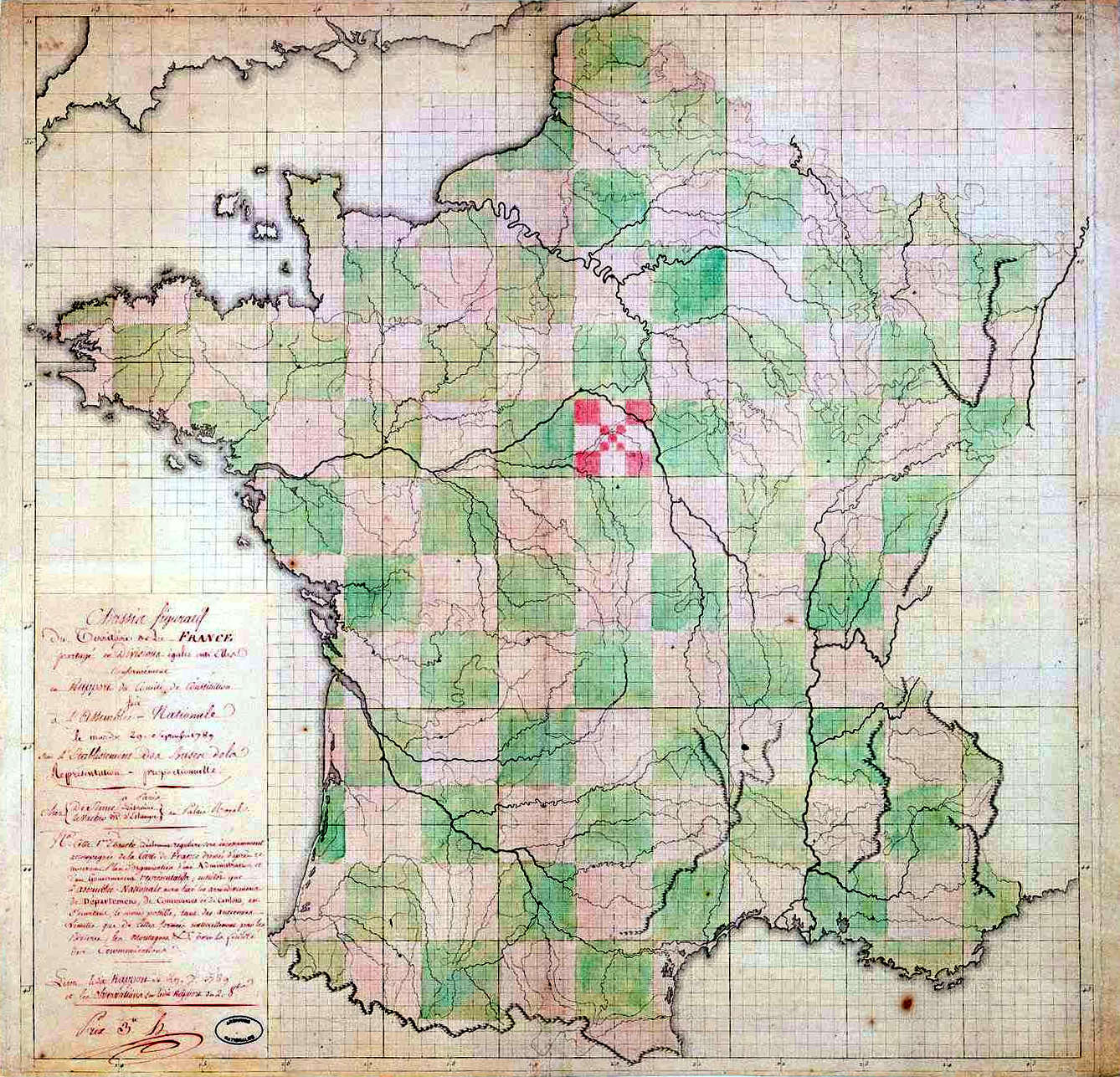
Interestingly, when the French decided to change a few things in 1789, they originally planned that their new departements should each be squares with sides of 66.7 km.
While this may be true, on a point of order, the metre was only defined in 1799, and myriamètre (10,000m) was used until the mid 1800s. As such the kilometre is unlikely to have been the definitive unit used on 1789
To be fair to Vierwielen, the French Revolution began in 1789, but had no specific end point. For instance, France was not declared a republic until 1792, and the king was not executed until 1793. It was only really after those events that the revolutionaries started to implement their radical new ideas.
I'd consider the revolution to have been 'ongoing' until at least 1799, when Napoleon seized power as First Consul, and you could argue that it didn't even end there; the French state's Concordat with the Catholic Church was not signed until 1801, and the Code Napoleon was not established until 1804. In much the same way, I've always considered the introduction of the metric system to be a part of the French revolutionary legacy.
One thing is interesting when you compare a map of France and its depts, Italy, Spain, Belgium, and the NL with their provinces is that the 'roughly the same size' idea is there in all of them. And it is there in the counties of these islands, a useful administrative unit size of geography.
What the issue was in the UK was Birmingham, Manchester, Liverpool grew to a point where the administrative purpose was fractured by the boundaries where as on a blank slate France could build around the main towns, Calvados and Caen, Gironde and Bordeaux, Indre et Loire and Tours. Though you have Manche and St Lo throwing that off and others! Spain and Italy just name the provinces after the seat.
So the 74 counties made sense, new counties for Avon, Humberside, Cleveland. New ones for population size for Wales. The problem for many is the nomenclature of them, what does 'county' mean, when people had a clear idea that Bath was in the County of Somerset, not the County of Avon, when it was in the County of Avon, and that of Somerset at the same time depending on the person and the meaning.
Did you know there's more to SABRE than just the Forums? Add your roads knowledge to the SABRE Wiki today!
Have you browsed SABRE Maps recently? Try getting involved!
exiled wrote: ↑Mon Apr 29, 2024 12:48
So the 74 counties made sense, new counties for Avon, Humberside, Cleveland. New ones for population size for Wales. The problem for many is the nomenclature of them, what does 'county' mean, when people had a clear idea that Bath was in the County of Somerset, not the County of Avon, when it was in the County of Avon, and that of Somerset at the same time depending on the person and the meaning.
Not all of them.
For example, the former West Midlands was (and is) an awful mess - parts of three entirely separate functional areas all jammed together with the smallest bounding possible meaning that no area gets supported properly. It would have made much more sense split into three, but with each of the three actually covering its full area - so "Greater Birmingham" should have included places like Redditch, Tamworth, Bromsgrove etc, "Greater Coventry" including most of the rest of northern Warwickshire, and "Greater Wolverhampton and the Black Country" including Cannock, Kidderminster, Telford, Bridgnorth, maybe even Stafford.
If you think the 1974 authorities made sense, then take a look at the Redcliffe-Maud proposed boundaries (and the Senior Alternative to that), which were pretty much based around functional areas.
Steven
Motorway Historian
Founder Member, SABRE ex-Presidents' Corner
Add your roads knowledge to the SABRE Wiki today!
Have you browsed SABRE Maps recently? Try getting involved!
exiled wrote: ↑Mon Apr 29, 2024 12:48
So the 74 counties made sense, new counties for Avon, Humberside, Cleveland. New ones for population size for Wales. The problem for many is the nomenclature of them, what does 'county' mean, when people had a clear idea that Bath was in the County of Somerset, not the County of Avon, when it was in the County of Avon, and that of Somerset at the same time depending on the person and the meaning.
Not all of them.
For example, the former West Midlands was (and is) an awful mess - parts of three entirely separate functional areas all jammed together with the smallest bounding possible meaning that no area gets supported properly. It would have made much more sense split into three, but with each of the three actually covering its full area - so "Greater Birmingham" should have included places like Redditch, Tamworth, Bromsgrove etc, "Greater Coventry" including most of the rest of northern Warwickshire, and "Greater Wolverhampton and the Black Country" including Cannock, Kidderminster, Telford, Bridgnorth, maybe even Stafford.
If you think the 1974 authorities made sense, then take a look at the Redcliffe-Maud proposed boundaries (and the Senior Alternative to that), which were pretty much based around functional areas.
Yup, and of course politics comes into play. IIRC one of the bits about why unitary councils stalled in Devon is Exeter and East Devon did not want to be in the same authority as poor Mid Devon, North Devon was more than happy to share an authority with rich Mid Devon, but MD wants Exeter as it is the natural area.
Did you know there's more to SABRE than just the Forums? Add your roads knowledge to the SABRE Wiki today!
Have you browsed SABRE Maps recently? Try getting involved!
Vierwielen wrote: ↑Tue Dec 12, 2023 19:05
Interestingly, when the French decided to change a few things in 1789, they originally planned that their new departements should each be squares with sides of 66.7 km.
While this may be true, on a point of order, the metre was only defined in 1799, and myriamètre (10,000m) was used until the mid 1800s. As such the kilometre is unlikely to have been the definitive unit used on 1789
A map of the proposed departements is shown here. I could not find a scale on the map, but latitudes and longitudes are mentioned. The latitudes appear to be degrees (the 50°latititude clipping Cornwall) and from this we can get an estimate of the size of the squares.
exiled wrote: ↑Mon Apr 29, 2024 12:48
So the 74 counties made sense, new counties for Avon, Humberside, Cleveland. New ones for population size for Wales. The problem for many is the nomenclature of them, what does 'county' mean, when people had a clear idea that Bath was in the County of Somerset, not the County of Avon, when it was in the County of Avon, and that of Somerset at the same time depending on the person and the meaning.
Not all of them.
For example, the former West Midlands was (and is) an awful mess - parts of three entirely separate functional areas all jammed together with the smallest bounding possible meaning that no area gets supported properly. It would have made much more sense split into three, but with each of the three actually covering its full area - so "Greater Birmingham" should have included places like Redditch, Tamworth, Bromsgrove etc, "Greater Coventry" including most of the rest of northern Warwickshire, and "Greater Wolverhampton and the Black Country" including Cannock, Kidderminster, Telford, Bridgnorth, maybe even Stafford.
If you think the 1974 authorities made sense, then take a look at the Redcliffe-Maud proposed boundaries (and the Senior Alternative to that), which were pretty much based around functional areas.
Yup, and of course politics comes into play. IIRC one of the bits about why unitary councils stalled in Devon is Exeter and East Devon did not want to be in the same authority as poor Mid Devon, North Devon was more than happy to share an authority with rich Mid Devon, but MD wants Exeter as it is the natural area.
I had the impression that a significant number of people in Barf didn't like the idea of being in Somerset.
Aylesbury seems to fit this criteria as a hub for the county’s road network in Buckinghamshire, perhaps more so before the motorways were built.
However, I’ve always considered the town quite difficult to access from anywhere except London (since the A41 was fully dualled from the M25 to Aylesbury).
Oxfordshire roads also converge at the city of Oxford. Even though the old roads continue into the city centre, the ring road around the outside links pretty much all the radial routes.
In Berkshire, I would not describe the previous county town of Abingdon as a road hub at all. Reading as the modern day county town sort of acted like a road hub in the days prior to motorways, the radial A-roads converged at the town centre. Thankfully, you can largely bypass this if travelling east-west via the M4 now (when it is open!). But north south traffic is restricted to travel through the centre.
exiled wrote: ↑Sun Apr 28, 2024 12:27The Revolution is generally agreed to have ended with the Coup of 18 brumaire year VIII (9th Nov 1799), though the Napoleonic imperial system would embed slowly. The official name of the state remained République Française for a while after Nap declared himself hereditary emperor.
It can also be argued that French history from then on through the 19th C was the Revolution's spin offs.
Got a good one, courtesy of Napoleonic Wars specialist Michael Broers:
"Napoleon was the French Revolution on horseback."
There is so much about the UK that would have benefited from the administrative impact of the French Revolution...


