https://www.sabre-roads.org.uk/maps/ind ... 16&layer=0
I noticed that this minor road in an industrial estate is in fact pretty good quality and extends most of the way from the A64 to Cayton; if around the same length of road were constructed again it would serve as a very natural way for the B1261 to bypass Cayton completely. It doesn't look like any such plans currently exist, but I'm wondering if anyone knows if plans to do so existed in the past?
Was Cayton Approach ever intended to bypass Cayton (Scarborough)?
Moderator: Site Management Team

Re: Was Cayton Approach ever intended to bypass Cayton (Scarborough)?
It looks as though it was just an access road to a much larger tin shed development that never happened. Most of the roads were built 15 years ago yet most of the land around it remains vacant. It's strange to see it recently extended eastwards when the existing area has remained undeveloped.
How would you like your grade separations, Sir?
Big and complex.
Big and complex.

Re: Was Cayton Approach ever intended to bypass Cayton (Scarborough)?
The short answer is yes.
The reality is that there was little affordable accommodation to be found between Whitby and Scarborough and the majority of the traffic to the cost was coming from Leeds/Bradford to the Holiday Parks between Scarborough and Reighton. The original route was a real drag taking you into Scarborough over Olivers Mount and past Cayton Bay where there were a multitude of caravan/holiday parks between Cayton Bay and Bridlington. Cayton is a small village but it was a major bottleneck for road traffic which is why Butlins paid for a spur to their holiday camp at Filey.
The reality is that there was little affordable accommodation to be found between Whitby and Scarborough and the majority of the traffic to the cost was coming from Leeds/Bradford to the Holiday Parks between Scarborough and Reighton. The original route was a real drag taking you into Scarborough over Olivers Mount and past Cayton Bay where there were a multitude of caravan/holiday parks between Cayton Bay and Bridlington. Cayton is a small village but it was a major bottleneck for road traffic which is why Butlins paid for a spur to their holiday camp at Filey.
-
NICK 647063
- Member
- Posts: 1725
- Joined: Sun Nov 28, 2004 17:48
- Location: Leeds
Re: Was Cayton Approach ever intended to bypass Cayton (Scarborough)?
Also Currently a new road being built from Musham Bank Roundabout on the A64 to Filey Road A165 P&R roundabout, it’s mainly a development route for the Deepdale area north of Eastfield but makes a useful link road and would be better taking the B1261 number and removing it from Cayton.
Re: Was Cayton Approach ever intended to bypass Cayton (Scarborough)?
I'm now wondering what the main traffic flow on the B1261 actually is. Having thought about it, I think it might well actually be traffic from the A170 to the Filey/Bridlington area, in which case it makes sense for the B1261 to retain its current route (answering my question in OP). After all, traffic from the Leeds area to Filey would use the A1039.NICK 647063 wrote: ↑Wed Dec 20, 2023 14:27 Also Currently a new road being built from Musham Bank Roundabout on the A64 to Filey Road A165 P&R roundabout, it’s mainly a development route for the Deepdale area north of Eastfield but makes a useful link road and would be better taking the B1261 number and removing it from Cayton.
Re: Was Cayton Approach ever intended to bypass Cayton (Scarborough)?
Typical traffic flows are as follows
A170 from Pickering to Scarborough at Box Hill - 8k
A171 from Whitby to Scarborough - 8k
A64 at Musham Bank - 15k
B1261 - 6k
A165 from Scarborough to Filey - 15k
A165 at Reighton - 10k
A165 entering Bridlington approx 10k
Of course on a sunny bank holiday weekend all bets are off
Before the Seamer Bypass was built the junction of the A64 and B1261 was a simple flat junction in Seamer. It was a major bottleneck which was replaced with the current layout. A particular bottleneck was the level crossing of the railway which was replaced with a flyover.
https://www.google.com/maps/@54.2414348 ... &entry=ttu
Cayton approach seems to have been intended as a southern bypass of Scarborough to take traffic to the holiday parks but instead the roundabout and flyover at Seamer was built. I would assume that the closure of the Butlins at Filey was an influence, it was very large and busy. At its peak it had its own railway station.
https://www.sabre-roads.org.uk/maps/ind ... 14&layer=0
The traces are still there, a short stroll took you straight into the reception.
https://www.google.com/maps/place/54%C2 ... &entry=ttu
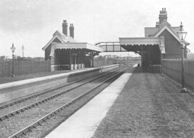
This was a pretty common setup in the 1960's. We went to the western themed holiday park at Hopton-on-sea, the station was here.
https://www.google.com/maps/@52.5393409 ... &entry=ttu
The holiday park is still there and now owned by Haven.
https://www.haven.com/parks/norfolk/hopton
A170 from Pickering to Scarborough at Box Hill - 8k
A171 from Whitby to Scarborough - 8k
A64 at Musham Bank - 15k
B1261 - 6k
A165 from Scarborough to Filey - 15k
A165 at Reighton - 10k
A165 entering Bridlington approx 10k
Of course on a sunny bank holiday weekend all bets are off
Before the Seamer Bypass was built the junction of the A64 and B1261 was a simple flat junction in Seamer. It was a major bottleneck which was replaced with the current layout. A particular bottleneck was the level crossing of the railway which was replaced with a flyover.
https://www.google.com/maps/@54.2414348 ... &entry=ttu
Cayton approach seems to have been intended as a southern bypass of Scarborough to take traffic to the holiday parks but instead the roundabout and flyover at Seamer was built. I would assume that the closure of the Butlins at Filey was an influence, it was very large and busy. At its peak it had its own railway station.
https://www.sabre-roads.org.uk/maps/ind ... 14&layer=0
The traces are still there, a short stroll took you straight into the reception.
https://www.google.com/maps/place/54%C2 ... &entry=ttu
This was a pretty common setup in the 1960's. We went to the western themed holiday park at Hopton-on-sea, the station was here.
https://www.google.com/maps/@52.5393409 ... &entry=ttu
The holiday park is still there and now owned by Haven.
https://www.haven.com/parks/norfolk/hopton
-
wallmeerkat
- Member
- Posts: 1334
- Joined: Fri Apr 20, 2018 16:49
- Location: County Down
Re: Was Cayton Approach ever intended to bypass Cayton (Scarborough)?
Presumably a North/South railway where the McColls shop is now? To the South did it sweep westwards slightly, (behind the rear gardens of the Old Church Road houses?) as what looks like an alignment is present?KeithW wrote: ↑Thu Dec 21, 2023 09:11
This was a pretty common setup in the 1960's. We went to the western themed holiday park at Hopton-on-sea, the station was here.
https://www.google.com/maps/@52.5393409 ... &entry=ttu
Re: Was Cayton Approach ever intended to bypass Cayton (Scarborough)?
It was at the end of Station Road which I believe was here where the Turnstone now is but the whole area has been developed. Back then the station was on the edge of the village with just a road down to the holiday camp.wallmeerkat wrote: ↑Thu Dec 21, 2023 13:29
Presumably a North/South railway where the McColls shop is now? To the South did it sweep westwards slightly, (behind the rear gardens of the Old Church Road houses?) as what looks like an alignment is present?
https://www.sabre-roads.org.uk/maps/ind ... 14&layer=0